

|
|
HydrologyA catchment is an area with a natural boundary (for example ridges, hills or mountains) where all surface water drains to a common channel to form rivers or creeks. Larger catchments are made up of smaller areas, sometimes called subcatchments[2].
Quick facts
Hydrology – Catchment and subcatchmentSelect from the tabs below
The hydrological processes of a catchment or subcatchment are influenced by the physical characteristics of the catchment as well as by the broader region and subregion. Subcatchments are also separated by a raised ridge or natural boundary within a catchment. In general, surface water does not flow from one subcatchment to another, however in relatively flat areas flood waters may cross a subcatchment boundary. In some cases, groundwater may cross subcatchment boundaries due to the underlying geology. 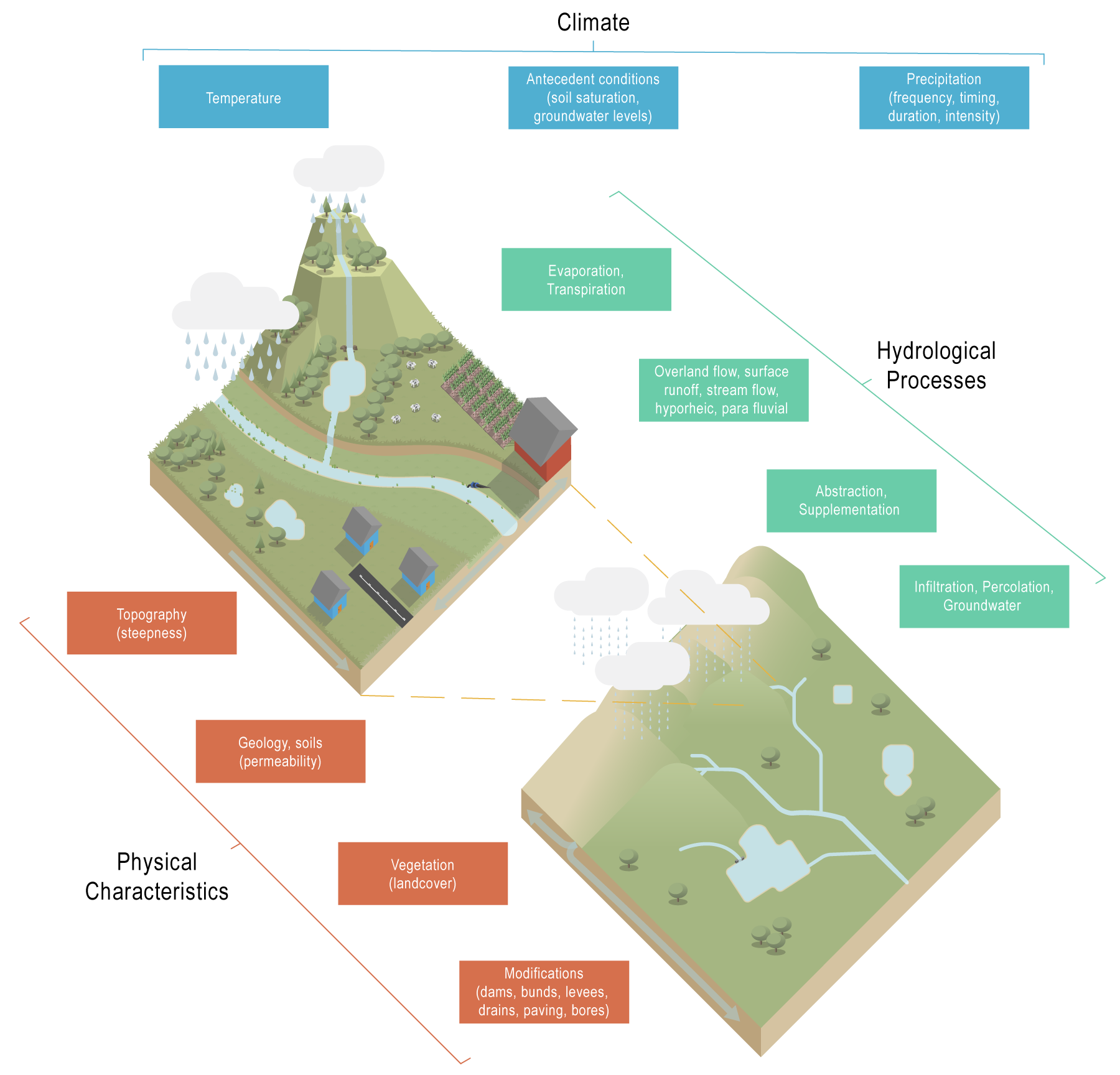
ClimateThe climate at the regional and subregional scales determines the overall water in the system. Rainfall, and other forms of precipitation, provide the source of surface water flows such as waterways and other, non-channelised overland flow, as well as groundwater. The processes of evaporation and transpiration (collectively ‘evapotranspiration’) cause the loss of water from the land to the atmosphere at a more local scale. Solar radiation, temperature, wind and vegetation cover influence these processes. Physical characteristicsGeology and topographyThe underlying geology of catchments in a region strongly influences the hydrology. Some rocks (such as some fine-grained sedimentary rock, metamorphic rock and igneous rock) and some unconsolidated sediments (such as clay deposits) have low/limited permeability and water falling on these surfaces can generate surface water run-off. Permeable rocks, such as basalts and unconsolidated sediments such sands and loams, can contain one or more aquifers, where groundwater is stored and transmitted through intergranular pore space, fractures, vesicles and/or weathered zone of the rock. The topography (shape of an area) has a direct impact on the hydrology. Topographic features such as slope and curvature can serve as indirect measures of many hydrological processes. Topography varies over several orders of magnitude, from centimetres (roughness) to hundreds of kilometres (mountain ranges). SoilsSoil texture affects the movement and retention of water. The ease with which water can move through the soil profile depends on the porosity of the soils or in other words the amount of “free spaces” (voids) through which water can flow. The rate of this movement is expressed as its hydraulic conductivity. The porosity is larger in coarse-textured soils (sands) than in fine-textured soils (clays). As a result, water (and dissolved nutrients) can move faster through coarse-textured soils than fine-textured soils[4], conversely fine textured soils will tend to generate more surface runoff. Soil porosity affects the movement and retention of water through the soil profile[4]. Vegetation (landcover)Vegetation affects water runoff in a number of ways. Some of the water that reaches the ground infiltrates into the soil and may be taken up by plant roots. Rain that is intercepted by, or held on, the vegetation canopy often evaporates to the atmosphere[3]. The roughness of the landscape also influences the speed of water movement across it. Complex habitats such as forested wetlands, with high density of trees and a developed understorey will significantly reduce flow speed. Simple habitats such as bare ground, or open forests with cleared understorey will provide little resistance to flows. ModificationsBuildings and infrastructure such as roads, railways and creek crossings create impermeable surfaces that stop the ingress of water into soils and can create barriers that redirect water through single points or culverts, leading to channelling of water. This increases the rate of flow and the potential for erosion. Modifications to channels, such as straightening and diversions, can also increase flow rates. Increases in the volume and speed of runoff can increase gully and streambank erosion in the landscape and the stream channels, resulting in sediment being transported downstream and adversely affecting water quality. Weirs, dams and rural water storages (farm dams) also modify natural water flow patterns, by holding water that would otherwise flow straight into the stream network. Hydrological processesWater can move through the landscape in many ways, including through surface water runoff and groundwater (groundwater recharge) and can transfer between the two systems[1]. The hydrological response of catchments to rainfall depends on the intensity and duration of rainfall and the amount of infiltration and runoff. Where the rainfall exceeds the infiltration capacity of the soil, the excess rainfall will generate the surface runoff that provides a stream’s flow. Water infiltrating into the soil may not go to stream or is often delayed in its passage to the stream channel. However, in catchments where infiltration rates are high enough to be only very rarely exceeded by storm rainfall intensities (e.g. sand islands), stream flows may either be generated almost entirely by subsurface flows or by surface flows when the soil is saturated. Water abstraction for agricultural and urban uses, and supplementation such as irrigation, also influence the movement of water. References
Last updated: 10 May 2021 This page should be cited as: Department of Environment, Science and Innovation, Queensland (2021) Hydrology – Catchment and subcatchment, WetlandInfo website, accessed 8 May 2025. Available at: https://wetlandinfo.des.qld.gov.au/wetlands/ecology/processes-systems/water/hydrology/landscape.html |
Site footer

 — Department of the Environment, Tourism, Science and Innovation