

|
|
HydrologyThe water regime of a land unit describes where, when and how much water is present, including the timing, frequency, duration, depth and variability of the water and it is influenced by the landscape characteristics, landscape hydrology and hydrological connections.
Quick facts
Hydrology – Land unit and subunitSelect from the tabs below
Catchment and subcatchment hydrology, position in the landscape, modifications and prior conditions combine to determine the inflows and outflows of a habitat or land unit.  Surface and groundwater may flow into and out of land units continually or periodically. This water may originate in the land unit as rainfall or cloud interception, or pass through it from elsewhere in the catchment in streams, drains, irrigation, floodwater or aquifers. At the land unit scale the processes of evaporation and transpiration also occur. 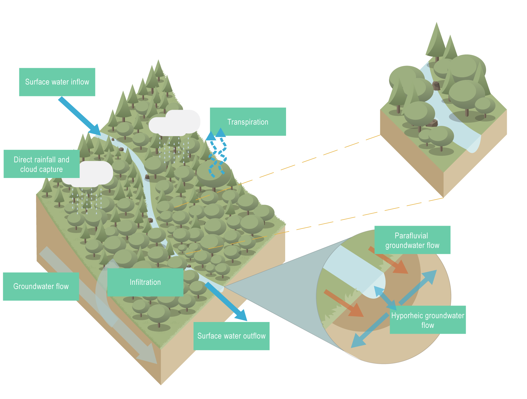 Rainfall reaches a stream via surface runoff or overland flow across the surface of the land toward a surface water body, through shallow groundwater, and via infiltration into the soil and percolation into deeper groundwater which enters the stream and contributes to baseflow. The water then becomes stream flow – also known as channel runoff, the flow of water in natural watercourses such as streams, creeks, and rivers. Water can also seep from deep underground aquifers to the surface when its pressure is great enough. Water flowing through a river can move through the sediments beneath and adjacent to the channel. These are termed hyporheic and parafluvial flows respectively.  Groundwater is water that has infiltrated beyond the unsaturated soil, or root zone (where plant roots generally occur) and percolated down to the saturated zone. The percolation of water depends on the nature of the landscape, including the type of soil and rock layers present, and how permeable they are (i.e. pores between grains and fractures in rock)[2]. Water abstraction is the physical removal of water from a water resource for use. It includes both surface water and groundwater sources. Supplementation, often in the form of releases of stored water (e.g. from dams) for irrigation can increase base flows in streams and extend periods of wetting for wetlands[1]. 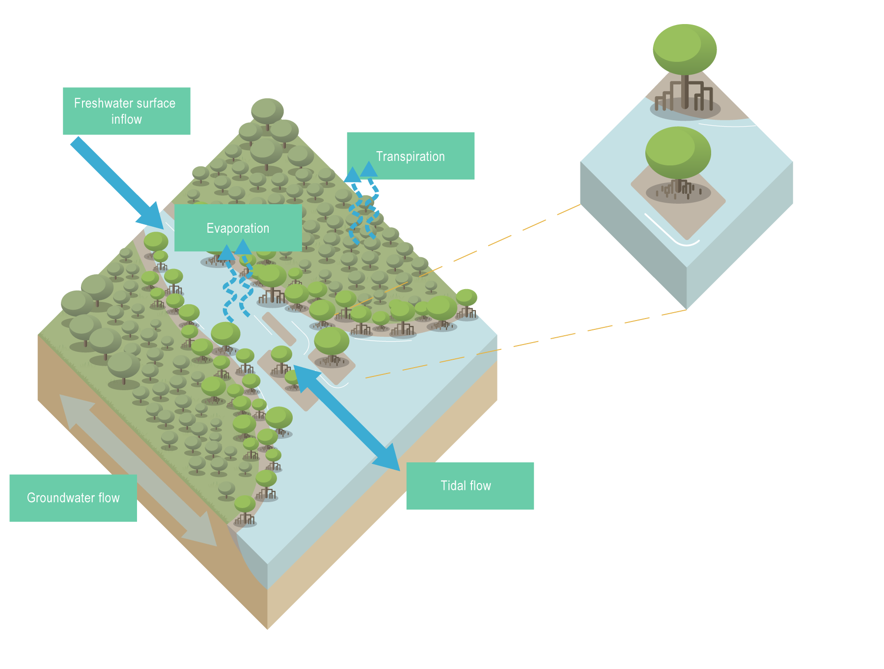 Tidal estuaries and creeks receive water from the ocean via tidal inflows. Larger estuaries can receive significant freshwater runoff from the catchment while small creeks may have very little freshwater. The quantity of freshwater input can vary seasonally, depending on regional climatic conditions. Groundwater input may also be a significant source of freshwater. Tidal creeks typically have well-mixed water circulation conditions, due to the mixing effect of strong tidal currents. The tidal range within tidal creeks may be amplified in comparison to the adjacent coastal ocean (depending on the geometry of the channel), and tides also tend to penetrate further inland with increasing tidal range. References
Last updated: 10 May 2021 This page should be cited as: Department of Environment, Science and Innovation, Queensland (2021) Hydrology – Land unit and subunit, WetlandInfo website, accessed 8 May 2025. Available at: https://wetlandinfo.des.qld.gov.au/wetlands/ecology/processes-systems/water/hydrology/habitat.html |

Site footer

 — Department of the Environment, Tourism, Science and Innovation