

|
|
FloodingFlooding is a natural phenomenon that occurs when water covers land that is normally dry. It may result from coastal of catchment flooding, or a combination of both.[3]. This can happen when it escapes from a natural watercourse, such as a lake, river or creek. It can also happen when water is released from a reservoir, canal or dam. For up to date information about flooding in Queensland, see Flood - Queensland Government, Flood - Get Ready Queensland, and Floodcheck Queensland. 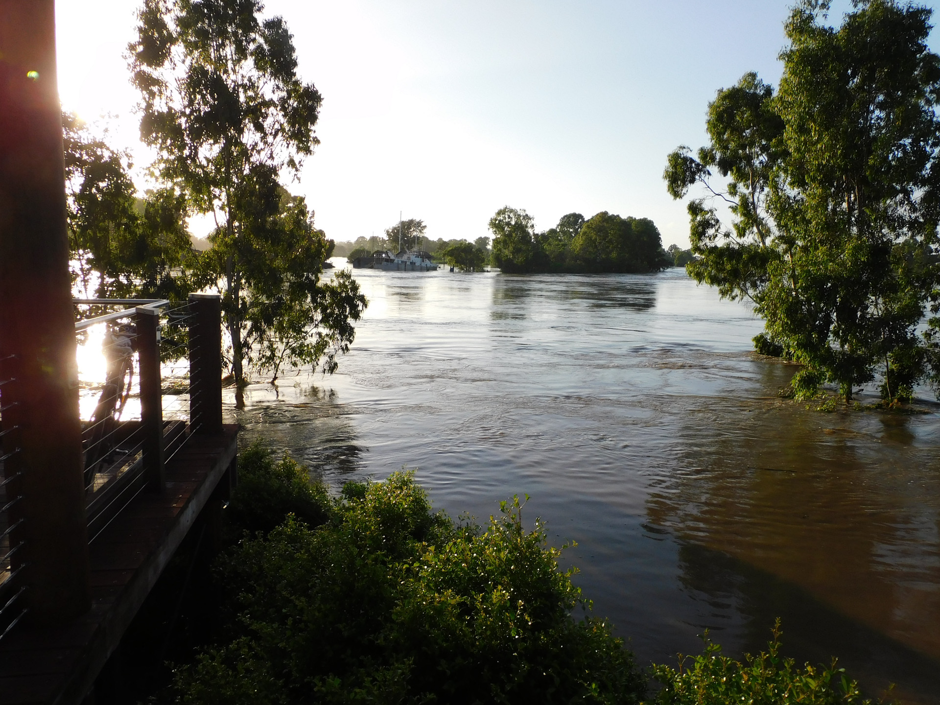
Many ecosystems in Queensland are adapted to floods and the flooding has a beneficial effect on many natural processes, such as[5]:
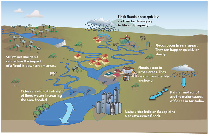
Flooding is also a major driver of the boom and bust cycle, such as in the Lake Eyre Basin. Human use of floodplains, such as through the building of infrastructure and hard surfaces, and clearing of vegetation, means the impact of flooding continues to be a prevalent issue. There are many types of flooding, and they vary greatly in size, frequency and severity. Smaller, local floods may be beneficial or are easy to manage, and some floods can have far reaching impacts on the environment, community and infrastructure and occur less frequently.Catchment flooding is flooding due to prolonged or intense rainfall (e.g. severe thunderstorms, monsoonal rains in the tropics, tropical cyclones). Types of catchment flooding include riverine, local overland and groundwater flooding[3]. Coastal flooding Flooding due to tidal or storm-driven coastal events, including storm surges in lower coastal waterways. This can be exacerbated by wind-wave generation from storm events[3]. Riverine flooding is the inundation of normally dry land occuring when water overflows the natural or artificial banks of a stream, river, estuary, lake or dam. Riverine flooding generally excludes watercourses constructed with pipes or artificial channels (such as stormwater channels)[3]. For example, riverine flooding occurs when rivers break their banks and water covers the surrounding land. The main cause is usually heavy rainfall, but it can also be caused by king tides, storm surge, snowmelt and dam releases. In inland parts of Queensland, New South Wales and Western Australia, episodic rainfall events contribute to riverine flooding that can affect thousands of square kilometres for weeks or even months at a time. Flash flooding is sudden and unexpected and often caused by sudden local or nearby heavy rainfall[3]. Flash floods tend to affect a localised area but can cause serious problems in urban areas if drainage systems can't cope[1]. Other flooding terminology may be used in local areas to describe the unique types of flooding that occurs there, such as the floods experienced due to the variable flow regimes in the Lake Eyre Basin. Floods in this catchment are extremely variable and never the same as previous floods. Despite this, the communities in the catchments term four flooding types that describe the unique flooding patterns:
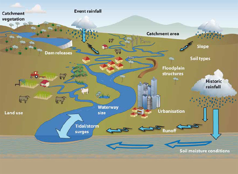
Smaller and more frequent flooding can be just as important as larger floods. Smaller floods prime the catchments for future flooding. As water spreads, temporary vegetation can establish, slowing the next flood pulse, with benefits for graziers. Causes of floodingThe most common cause of riverine and flash flooding is heavy rainfall. Rivers are formed over thousands of years form in response to the usual amount of local rainfall and runoff, and the local topography, vegetation and soil types. These features stay relatively constant through time, apart from variable rainfall. More rainfall than usual in a catchment creates more runoff. Rivers have a maximum capacity to carry water and if this runoff is unable to be carried by the river channel, it spills out onto the surrounding land. Riverine floods can happen shortly after rainfall, in localised areas and river flood peaks are often reached within days of rain falling. However, because many Australian rivers are long, floods can also occur weeks or months after rain, sometimes hundreds of kilometres away. For example, flood water in the upper Murray River, Australia's longest at over 2,500 km, may take months to reach the river mouth in South Australia[1] Coastal flooding can occur when the land is lying lower than the sea level/height, and there are no natural barriers such as dunes. Coastal flooding can also occur as water spills over a barrier (such as dunes or a dam or bund) during storms, storm surges and/or high tides. Contributing factors to coastal flooding are the height of land above sea level, the degree of erosion and state of vegetation. Coastal vegetation intercepts rainfall, slowing down its movement and absorbs water from the soil allowing more significant infiltration into the ground, as a result reducing surface runoff. When vegetation is removed, infiltration and interception are reduced and surface runoff increases. This increases the risk of flooding as more water reaches the river channel. Coastal vegetation stabilises existing sediment and traps new sediment, raising the height of the land above sea level. In addition, it absorbs wave energy, reducing wave impact and erosion, and reduces the distance waves travel onshore before their power is exhausted. For example, mangroves approximately reduce storm surge water levels from 5 to 50 centimetres per kilometre of mangrove width[2]. Wetlands and floodplains play a major role in flood mitigation and disaster management. References
Last updated: 23 October 2023 This page should be cited as: Department of Environment, Science and Innovation, Queensland (2023) Flooding, WetlandInfo website, accessed 8 May 2025. Available at: https://wetlandinfo.des.qld.gov.au/wetlands/ecology/processes-systems/flooding/ |
Site footer

 — Department of the Environment, Tourism, Science and Innovation