

|
|
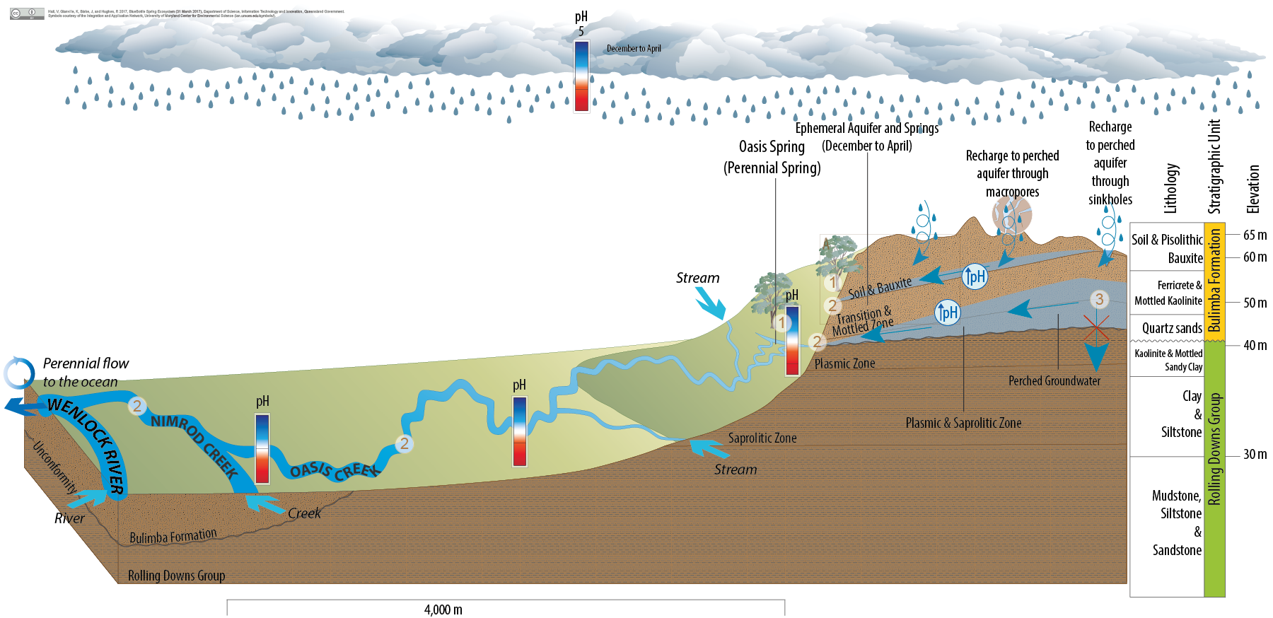
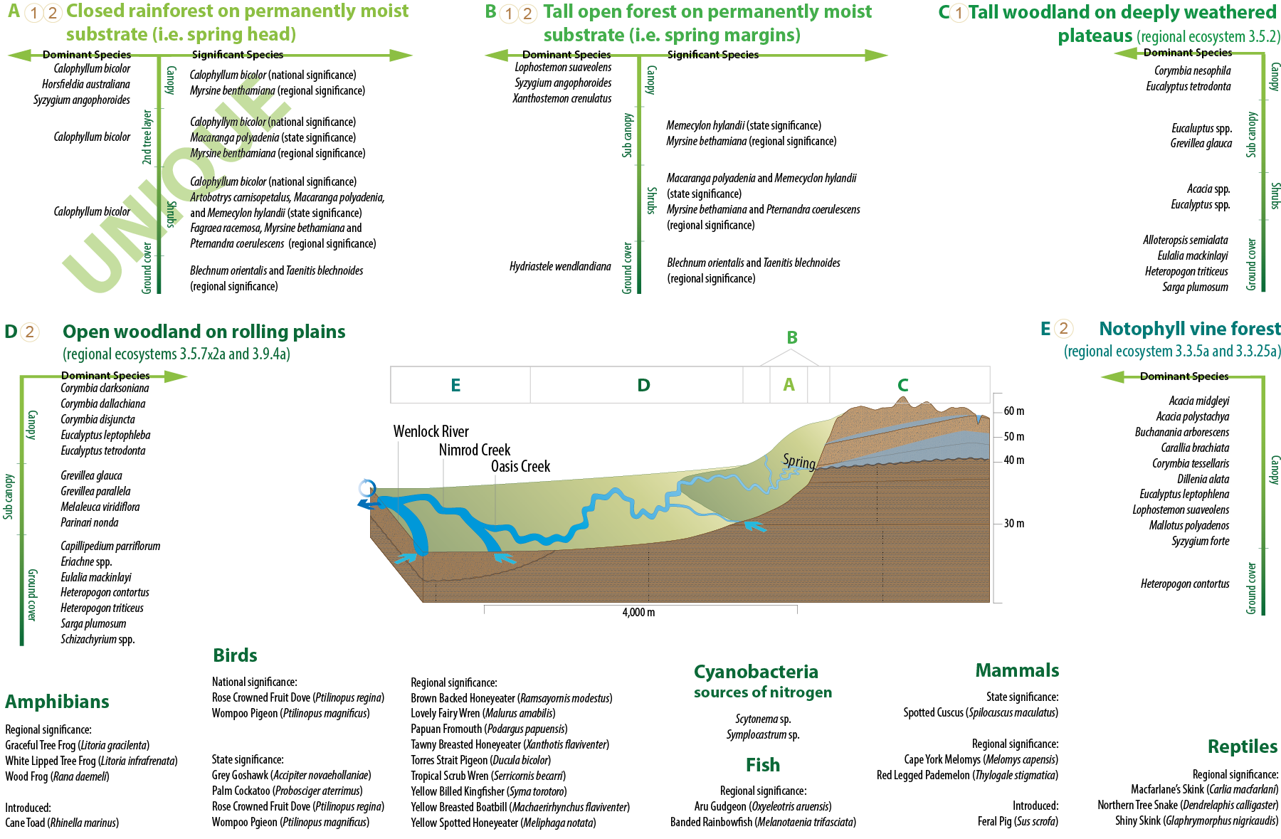
Oasis SpringOasis SpringClick on elements of the model or select from the tabs below Oasis Spring, Cape YorkOasis Spring is a permanent bauxite spring in Weipa Plateau supported by an aquifer overlying, but separate to, the Great Artesian Basin. Weipa Plateau is a remnant of the extensive, deeply weathered western coastal plains of Cape York Peninsula[8]. This plateau is an estimated 50 km wide with slight elevation of up to 15 m near the coast, rising to 70 m in the east[8]. The gently rolling hills of the plateau are dissected by discontinuous drainage and deep incisions that have been carved out by major rivers such as the Archer and Wenlock Rivers[6][2][8]. Based on information collected during a drilling program conducted by[9], the following sequence of geological layers near Oasis Spring is consistent with the broader geological profile of the Weipa Plateau[1][3][7].
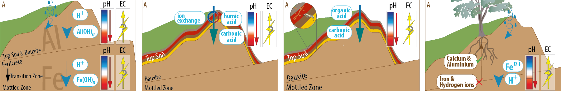
Groundwater discharge can occur where a permeable geological layer (e.g. Bulimba Formation) overlies a less permeable layer (e.g. Rolling Downs Group). At this site plasmic zone (b) is composed of well-compacted clay that acts to slow or prevent vertical groundwater flow. Given sufficient rainfall and recharge, this can result in groundwater accumulating above the clay and flowing laterally until it is discharged to the surface (e.g. Oasis Spring). In addition, groundwater may accumulate on less permeable kaolinite in other geological layers (e.g. mottled zone) and flow laterally until it is discharged to the surface or able to continue vertical movement. Oasis Spring occurs in a 240-metre arc at approximately 40 metre elevation near the contact between the Bulimba Formation and underlying the less permeable plasmic zone of the Rolling Downs Group. A relatively deep perennial gully incises the spring head at approximately its centre point and this becomes the main spring watercourse (Oasis Creek). Oasis Spring coalesces into a main stream approximately 100 metres downstream of the spring head. Oasis Creek flows into Nimrod Creek which then joins the Wenlock River in its freshwater, non-tidal reaches. In addition to the clear running streams, permanently saturated ground exists in parts of the springs eastern flank. Oasis Spring features strong perennial flow at the spring head and downstream for 800 metres even during the peak of the dry season. In 2008 permanent flow into Nimrod Creek was observed until August, although this flow slowly declined as the dry season progressed. Lyon and Franklin (2009)[5] have indicated that the water draining from the springs is acidic with an observed pH of 3.8 at the point of discharge and noted that the pH of the groundwater decreases with increasing distance from the spring. A number of factors have been identified that may contribute to spring acidity including rainfall acidity, chemical weathering, plant activity, decay of vegetation, termite activity, bacteria activity and fungi activity. Recent research supports the contribution of anerobic microbial degradation to groundwater chemistry[4]. In addition, isotopic values at the spring suggest groundwater has meteoric origins, representing a mix of rainfall events[4]. Pictorial conceptual model PDF References
Last updated: 10 April 2017 This page should be cited as: Queensland Government, Queensland (2017) Oasis Spring, WetlandInfo website, accessed 18 March 2024. Available at: https://wetlandinfo.des.qld.gov.au/wetlands/ecology/aquatic-ecosystems-natural/groundwater-dependent/oasis-spring/ |
Site footer

 — Department of Environment, Science and Innovation