|
|
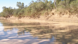
Productivity in the Murray-Darling Province—A case studyPrimary production and food webs in isolated waterholes have been studied in turbid floodplain rivers, typical of much of the Murray-Darling Province[1]. It was expected that, given the high turbidity and thus limited light penetration, aquatic primary production would be light limited and the riverine food web would be dependent on terrestrial carbon. However, the band of algae along the shallow littoral zone of waterholes, where light can penetrate to the streambed, was found to be highly productive (about two orders of magnitude greater than that measured in the main channel). Quick facts?
Stable carbon isotope analysis showed that terrestrial carbon was not an important source of energy in the aquatic food web despite its presence in large quantities. However, the littoral band of algae was the major source of energy for aquatic consumers, ultimately supporting large populations of invertebrates and fish. Much of the observed spatial variation in benthic primary production in turbid river waterholes can be explained by variations in turbidity and this, in turn, may be influenced by waterhole morphology[1] In-channel flows in these turbid rivers are likely to have a significant influence on aquatic primary production. Depth increases of only 20cm are likely to curtail benthic primary production as algae become submerged below the photic depth. Flow events that last for days to weeks may have significant consequences for consumers dependent on algal food resources[2]. In these turbid systems, the contribution to productivity by the phytoplankton is low. Generally the phytoplankton is dominated by flagellated cryptophytes, eugleonphytes and chlorophytes which are able to actively maintain their position in the water column, and in relation to the very shallow photic depth[5]. The other major algal community is restricted to the benthos. Many of these species form littoral bands along the shoreline of streams and waterholes and are motile, thus potentially capable of tracking fluctuations in water depth[5]. Isotopic signatures further indicated that zooplankton (presumably feeding on phytoplankton) was the other likely major carbon source[1]. The infrequently inundated floodplains typical of much of the Murray-Darling Province are another important location for aquatic primary production. Primary production on similar floodplains in the Lake Eyre and Bulloo Province has been studied by Bunn et al.[3]. Shortly after floodplain inundation rates of benthic and pelagic gross primary production were low, although there was a high rate of benthic respiration. After 1 month of inundation, high rates of benthic metabolism were recorded. Although rates were not as high as those observed in waterholes during prolonged dry periods, Bunn et al.[2] estimated that, because of the large floodplain areas inundated, the amount of algal carbon produced on the floodplain during a single day of inundation at this time was equivalent to over 80 years of aquatic production in the permanent waterholes during the dry. References
Last updated: 22 March 2013 This page should be cited as: Department of Environment, Science and Innovation, Queensland (2013) Productivity in the Murray-Darling Province—A case study, WetlandInfo website, accessed 8 May 2025. Available at: https://wetlandinfo.des.qld.gov.au/wetlands/ecology/components/atmosphere-physical/light/productivity-murray-darling-cb-case-study.html |

 — Department of the Environment, Tourism, Science and Innovation


