Spring ecosystems of the Surat and southern Bowen Basins—overview
Overview
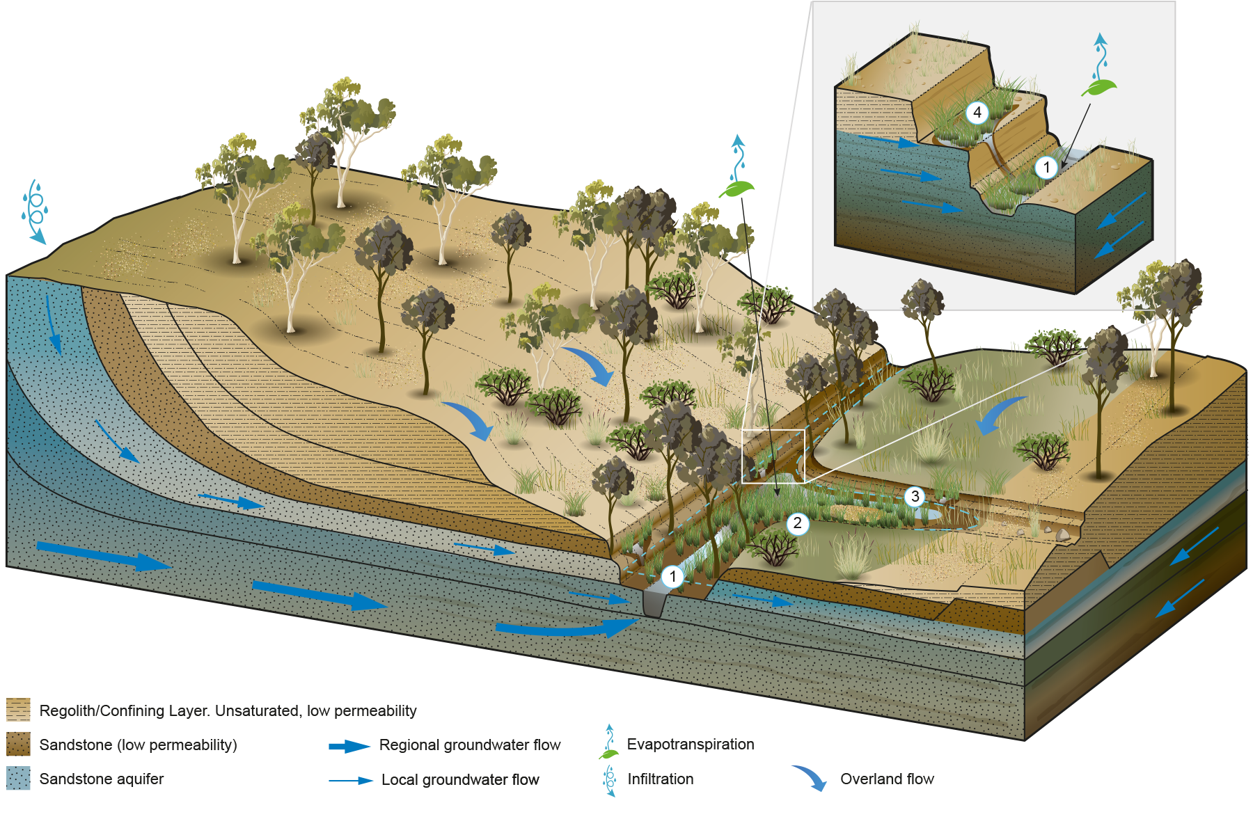
Springs in the Surat and southern Bowen basins are predominantly fed by Triassic and Jurassic aquifers including the Clematis Sandstone, Precipice Sandstone, Boxvale Sandstone Member of the Evergreen Formation, Hutton Sandstone, Gubberamunda Sandstone and Bungil Formation. In addition to these sedimentary aquifers, springs are also associated with unconsolidated Cenozoic sediments and the fractured rock aquifers of the Tertiary Volcanics. Individual springs can occur due to one or more of three basic mechanisms:
Fractures and faulting
changes in permeability both between and within individual formations
erosion and dissection of the landscape by surface water processes.
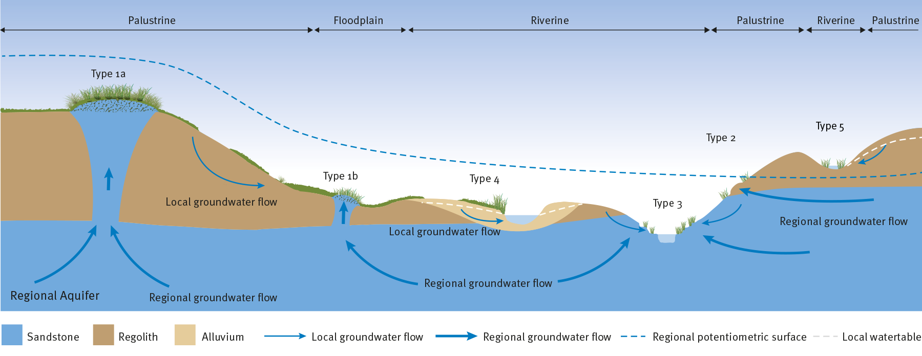
The wetlands supported by spring discharge vary considerably. Although it is important to understand the mechanism and source aquifer supporting a wetland, it is the receiving environment which will influence the way a wetland will respond to a change in the groundwater regime. For this reason, a wetland typology has been developed for spring ecosystems of the Surat and southern Bowen Basins which identifies four types of wetlands. The key attributes used to differentiate the wetland types are their landscape setting, geomorphology, the nature of the groundwater flow system, the regolith and water regime.
The four wetland types are:
Type 1: Permanent fresh-to-brackish, palustrine wetlands with well-developed peat wetland soils, dense vegetation coverage, mainly connected to regional and local groundwater systems.
Type 1a: Wetlands located in off-stream environments, on floodplains.
Type 1b: Wetlands located at the interface between floodplain and riverine environments and influenced by surface water flows.
Type 2: Semi-permanent brackish, palustrine wetlands with minor wetland soils and minor vegetation cover, mainly connected to regional groundwater systems.
Type 3: Permanent to semi-permanent riverine wetlands with minor wetland soils and moderate vegetation cover, sourced from local and regional groundwater systems and significantly influenced by surface water flows.
Type 4: Semi-permanent fresh riverine-to-palustrine wetlands with minor wetland soils and moderate vegetation cover, mainly connected to local groundwater systems, located within riverine environments with deep, sandy, alluvial deposits.
Type 5: Wetlands located within riverine-to-palustrine environments with shallow-to-nil unconsolidated material. These wetlands can form in areas of where there is significant topographic variation, such as the recharge areas of the Great Artesian Basin..
Spring ecosystems of the Surat and southern Bowen Basins—Type 1
Type 1a Wetlands located in off-stream environments, within floodplains
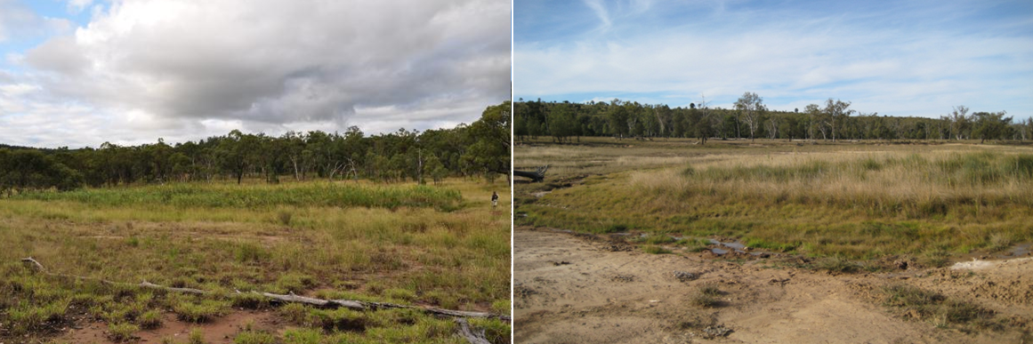
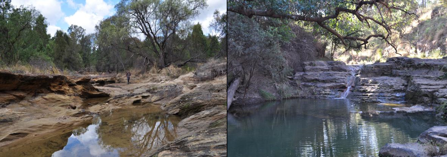
Examples of type 1a spring wetlands (Lucky Last (left) and Scott’s Creek (right))
Photos by Office of Groundwater Impact Assessment
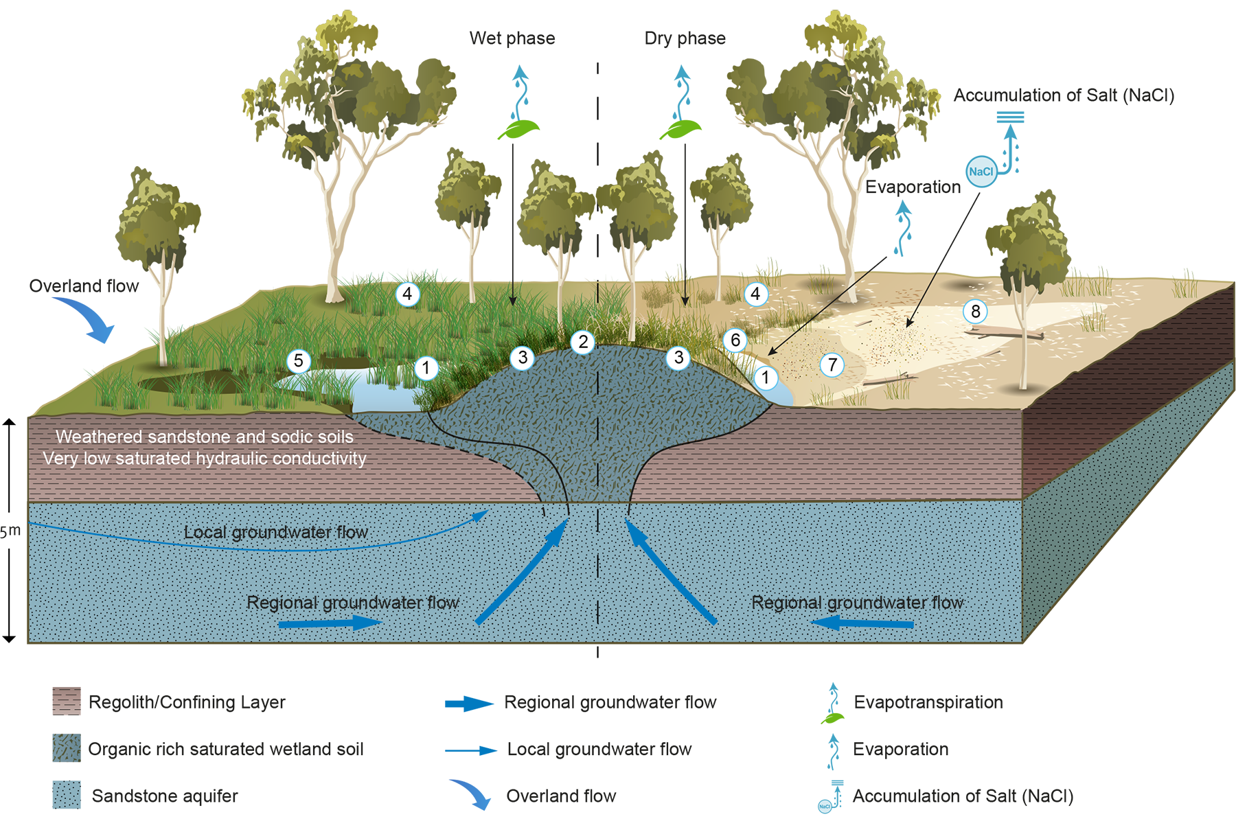
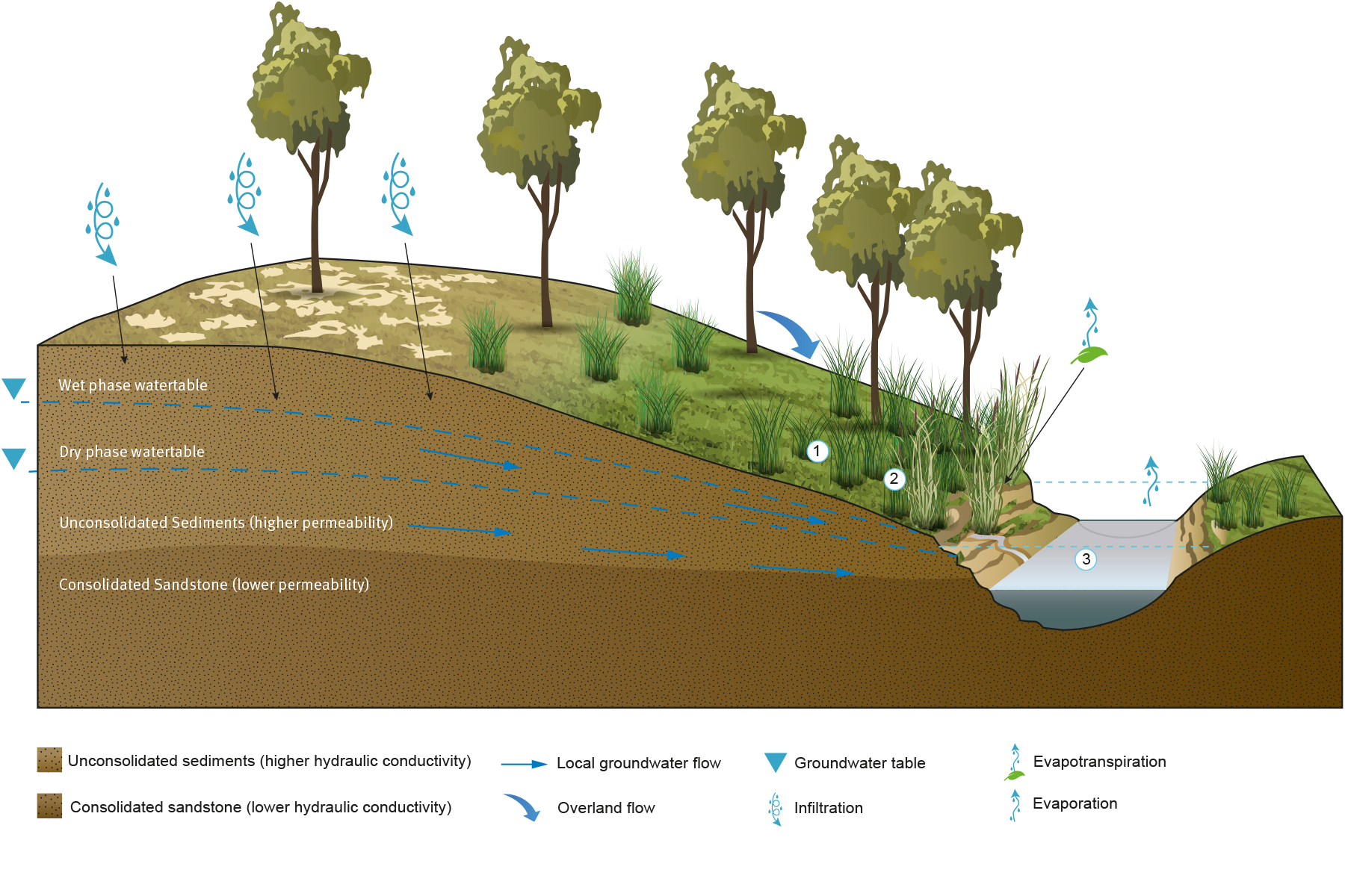
Type 1a wetlands occur in palustrine landscape settings, within topographic lows, gently sloping landscapes and occasionally on floodplains. The wetlands are supported by groundwater inflows from both regional and local groundwater systems, and predominantly occur over deep regolith profiles. The permanent supply of groundwater has enabled the development of peaty wetland soil and mounding.
The wetland water budget is dominated by diffuse discharge and evapotranspiration. During cooler months (outside of summer) when evapotranspiration is low, wetlands may free-flow and pooling can occur depending on the wetland geometry.
The permanent supply of groundwater and deep regolith have enabled a dense coverage of wetland vegetation, including large woody vegetation. The wetlands are characterised by a central core of aquatic vegetation that corresponds to the subsoil development of peaty wetland soil. The immediate area of the wetland is confined by the low hydraulic permeability of the surrounding regolith, contributing to the formation of discrete wetlands.
The wetlands are influenced by seasonal changes in climate, longer-term changes in climate and changes in groundwater pressure. During dry periods, the central core of the wetland remains saturated and is dominated by aquatic vegetation. Over this period, the extent of saturated soil and aquatic vegetation is very similar. During cooler and wet periods, wetland discharge increases, which results in an increased wetland area that may result in free-flowing water inundating downslope areas.
Short-term, seasonal changes result in the formation of an outer rim of dried and pugged soil that is often coated in salt efflorescence and iron staining. Long-term changes are expressed as multiple generations of woody vegetation, both living and dead, small ephemeral discharge zones and extensive ephemerally saturated discharge tails.
Type 1 wetlands form around a central core of saturated wetland soil. Eight focal zones have been identified primarily on the basis of wetland vegetation. The zones represent the variability across the wet and dry phase of the wetlands, driven by the groundwater regime. These are:
Zone of permanent inundation and/or flowing discharge. This area is dominated by wetland grasses (Leersia hexandra), tall sedges (Baumea rubiginosa and Schoenoplectus spp.) and floating forbs (Utricularia spp.). Where sufficient pooling occurs, this zone is forms a suitable macroinvertebrate habitat. During the dry phase, increased water salinity is observed in this zone.
Zone of aeration and reduced saturation. On some smaller mounds, shallow-rooted shrubs such as Leptospermum polygalifolium are present. On some larger mounds, larger trees including Lophostemon suaveolens and Eucalyptus camaldulensis are present. These indicate significant build-up of peat and/or soil, allowing adequate aeration for development of woody root vegetation assemblages.
Saturated shoulder of the mound. These areas are often dominated by a tall grass/sedge/rush community such as the tall grasses (Phragmites australis), sedges (Baumea rubiginosa, or Schoenoplectus spp.), ferns (Cyclosorus interruptus) and other species characteristic of permanent saturation. During the dry phase, increased water salinity is observed in this zone.
Non-wetland area. These areas are often dominated by a lawn of Cynodon dactylon or can be scalded bare ground with a range of other terrestrial species such as the exotic grass Chloris gayana.
Discharge tail during the wet phase. The tail area is often dominated by the sedge Carex appressa, the grass Leersia hexandra and, in very wet tails, Eleocharis spp.
Wetland to non-wetland transition zone. This zone occurs in a fringing areas of the wetland outside of the discharge area and mound. Soils in this area are saturated with little free water. The area is dominated by grasses including Cenchrus purpurascens, Sacciolepis indica, Isachne globosa and Arthraxon hispidus, a range of forbs such as Ranunculus lappaceus and the fern Cyclosorus interruptus. These species are generally associated with permanent saturation. However, this zone also includes a small proportion of terrestrial species, such as Imperata cylindrica or Dianella longifolia, particularly near the wetland boundary.
Discharge tail during dry phase. The sedge Carex appressa is still prominent. Increased areas of bare ground with terrestrial species such as the grass Cynodon dactylon. This area is often pugged by cattle.
Discharge tail during the dry phase. Notable features include ground affected by salt scalding, iron staining, often pugged by cattle and the absence of vegetation mentioned in zone 7.
Type 1b Wetlands located at the interface between floodplain and riverine environments and influenced by surface water flows
Examples of type 1b spring wetlands (Scott’s Creek complex, riverine wetlands)
Photos by Office of Groundwater Impact Assessment
Type 1b wetlands share very similar conceptual model and wetland processes with Type 1a, however the areas where they occur within the landscape are different. Type 1b wetlands occur at the interface between the floodplain and riverine setting. As a result, Type 1b wetlands have two important differences to Type 1a wetlands:
The depth of regolith and wetland soil development is thinner, due to the dissected nature of the adjacent riverine landscape and shallower depth to underlying source aquifer (< 20 m)
the adjacent riverine landscape may provide an additional water supply during high stream flow events.
Spring ecosystems of the Surat and southern Bowen Basins—Type 2
Type 2 Semi-permanent brackish, palustrine wetlands with minor wetland soils and minor vegetation cover, mainly connected to regional groundwater systems
Examples of type 2 spring wetlands (Abyss complex)
Photos by Office of Groundwater Impact Assessment
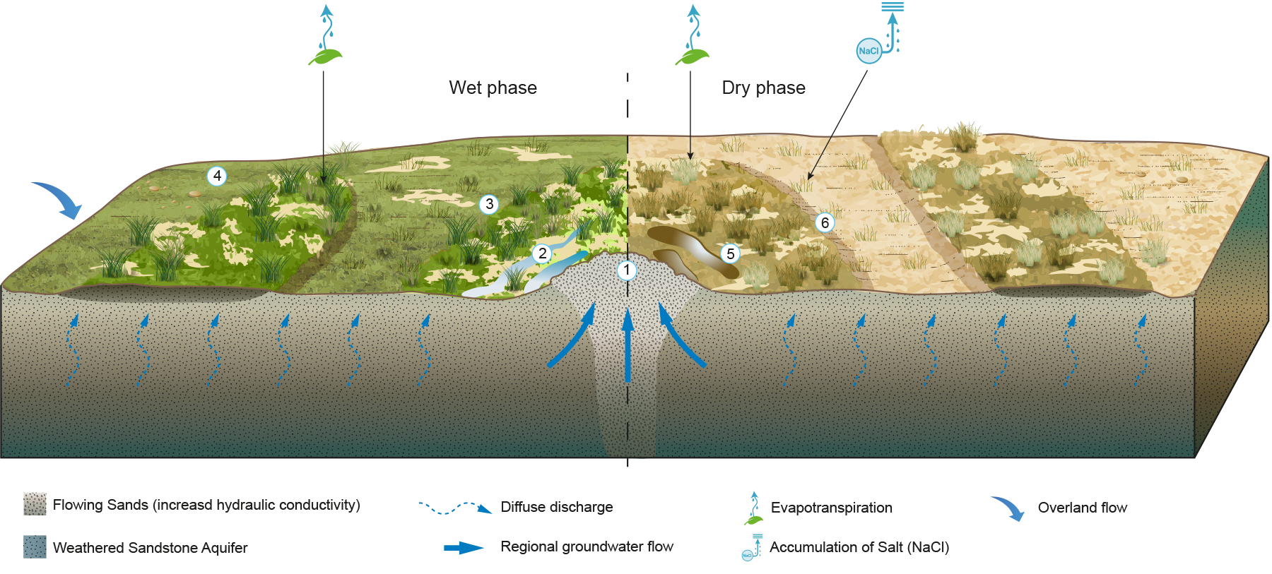
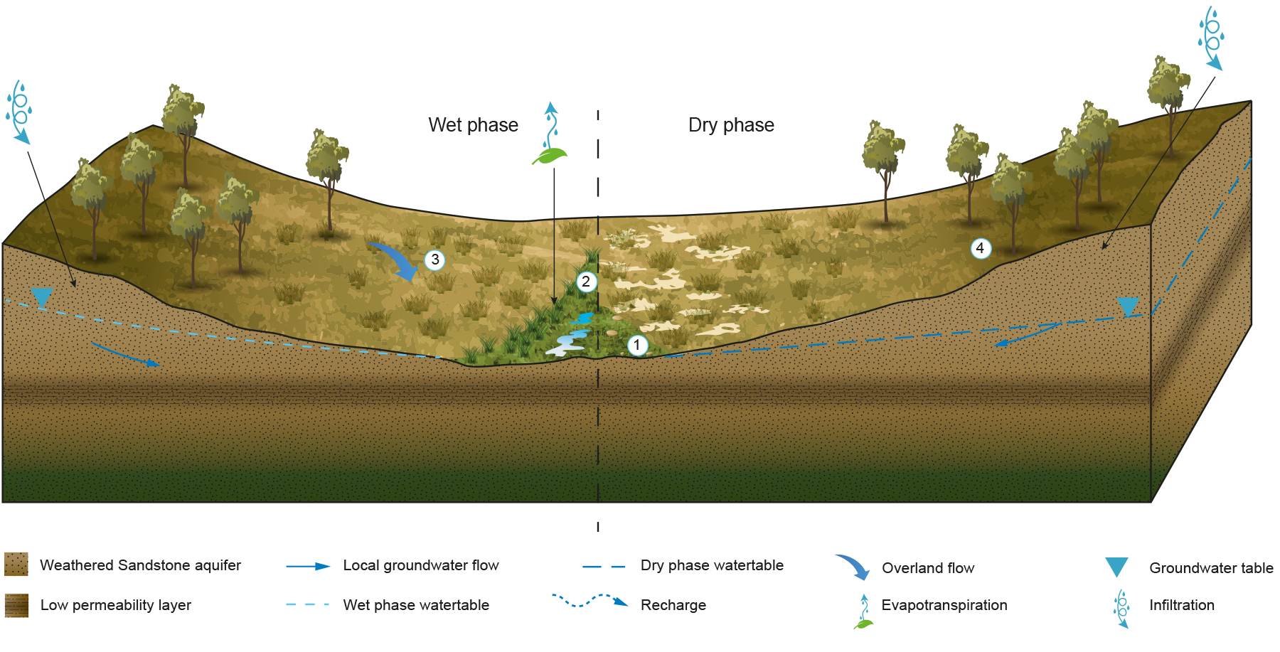
Type 2 wetlands occur in palustrine landscape settings, located within topographic lows or gently sloping landscapes. The wetlands occur on highly weathered regolith profiles, often sodic soils and receive groundwater inflows predominantly from regional groundwater systems. The wetland water budget is dominated by diffuse groundwater discharge. These wetlands are not permanently connected to the groundwater system.
Type 2 wetlands are relatively small wetlands and are dominated by terrestrial vegetation, with little to no free water. The semi-permanent connection to the groundwater system has not enabled the development of distinct wetland soils. It is likely that during extended dry periods, there is no physical discharge from these wetlands. The wetlands are often associated with a broader saline discharge zone that is actively eroding and is characterised by ‘flowing sands’ that create small non-vegetated mounds.
Six focal zones in the wetland vegetation have been identified that represent variability across the wet and dry phases of the wetlands, driven by the groundwater regime:
The main area of groundwater discharge, characterised by minor ‘flowing sands’ and limited vegetation.
The wetland transition zone and adjacent wet areas. This area contains some free-standing water (< 5 cm deep), a range of forbs including Bacopa minima and sedges such as Fimbristylis spp. indicative of less permanent saturation. The area has a low density of vegetation cover and is dominated by terrestrial species such as Chloris gayana, Cynodon dactylon and the invasive wetland species Paspalum distichum.
Non-wetland and broader diffuse groundwater discharge area. Dominated by terrestrial grass species such as Chloris gayana and Cynodon dactylon intermixed with a substantial amount of bare ground.
Scalded areas during the wet phase. Bare scalded ground (caused by diffuse discharge of saline groundwater) covered by a thin crust of dry eroded sands. This area is intermixed with a sparse cover of terrestrial grasses including Chloris gayana, porobolus mitchellii and Aristida spp. This area is interspersed with remnant ‘A horizon’ stacks – upper parts of the soil profile which have not been eroded -slightly elevated above the scalded area, such that some leaching of the soil occurs, removing salts.
Wetland transition area during the dry phase. No open water, dominated by unconsolidated sands.
Non-wetland and broader diffuse groundwater discharge area during the dry phase. Reduced ground coverage with more exposed sodic soils than other areas.
Spring ecosystems of the Surat and southern Bowen Basins—Type 3
Type 3 Permanent to semi-permanent riverine wetlands with minor wetland soils and moderate vegetation cover, sourced from local and regional groundwater systems and significantly influenced by surface water flows.
Examples of type 3 wetlands (Barton (left) and 311 (right))
Photos by Office of Groundwater Impact Assessment
Type 3 wetlands generally occur within active watercourses on exposed sandstone bedding planes. The wetlands have minor substrates, with the wetland soil forming through the accumulation of riverine sediment or bed sands, rather than exclusive development of wetland soil over time. The wetlands receive groundwater contributions from both regional and local groundwater systems and are predominantly actively discharging wetlands, with little soil water storage potential or evapotranspiration demand. The wetlands contain only minor wetland vegetation (due to lack of soil substrate).
Only minor seasonal changes occur to the spatial extent of the wetland as there is a constant supply from groundwater discharge. Long-term changes in wetland area will be influenced by stream erosion and deposition processes which are likely to alter the wetland area and location of discharge.
Discharge from the wetland is maintained all year and is either within, or adjacent to, permanent or semi-permanent watercourses. The shape and size of the wetland are controlled by the nature of the exposed sandstone and the geomorphology of the watercourse. The constant exchange of water due to discharge from the wetland and flow of low-salinity groundwater into the wetland generally maintains low-salinity water within the wetlands.
Only shallow wetland soils have developed at these wetlands. As a result, changes in groundwater discharge or a decline in evapotranspiration demand results in a change in the volume of discharge and minor changes to the wetland area. This is due to the wetlands having little regolith or wetland soil development and therefore limited water storage capacity to buffer the effects of an altered water balance.
Change to the wetland area is controlled by large-scale high flow surface water events rather than groundwater discharge. Within the current hydrogeological state, seasonal changes in groundwater discharge to the wetlands appear to have a negligible impact on the wetland. While it is expected that changes in groundwater discharge will have a negative impact on the wetlands, the condition of the wetlands is dominated by surface flow events.
These wetlands are characteristically wet and do not have a dry cycle. During the wettest phase, they are inundated to a degree by surface flow. During the lower flow periods, the wetlands are maintained by groundwater. Smaller wetlands located upstream of the main watercourse vary in vegetation type, with terrestrial and weed species occurring. In contrast larger wetlands are generally dominated by aquatic vegetation assemblages.
Type 3 wetlands have formed due to dissection of the landscape by riverine processes which results in the watertable being intersected within a sandstone aquifer. This creates zones of groundwater discharge (wetlands) adjacent to, or within permanently or seasonally flowing streams. Three focal zones have been proposed that represent the variability across the wetlands driven by the groundwater regime:
Area of permanent groundwater discharge which maintains saturation and pools of free water. Aquatic species include the Spangled Perch. Dominant plant species include the grasses Isachne globosa, Leersia hexandra and Sacciolepis indica indicative of permanent saturation, with species such as Schoenoplectus mucronatus, S. validus and Persicaria hydropiper prominent in wetter areas near the main points of groundwater discharge.
Terrestrial areas adjacent to the creek line. Dominant plant species include Chloris gayana and Cynodon dactylon. There may be a substantial amount of bare ground pugged by cattle.
Area of seasonal inundation and local groundwater discharge within the creek line. Aquatic species include midges and mayflies. Bare ground or fringing vegetation indicating saturation, including sedges Juncus prismatocarpus, Gahnia aspera and Cyperus spp., the bullrush Typha spp. and grasses such as Paspalum spp.
Within the creek line, there are areas of seasonal inundation and local groundwater discharge.
Spring ecosystems of the Surat and southern Bowen Basins—Type 4
Type 4 Semi-permanent fresh riverine-to-palustrine wetlands with minor wetland soils and moderate vegetation cover, mainly connected to local groundwater systems.
Examples of type 4 spring wetlands (Wambo complex)
Office of Groundwater Impact Assessment
Type 4 wetlands occur within active watercourses within deep sandy alluvial deposits. The wetlands receive groundwater inflows from local groundwater systems. Groundwater discharge from the wetlands is fresh and free-flowing. The lack of any clay substrate prevents any significant subsoil water storage and as a result, only very minor wetland soil can develop.
The wetlands contain an irregular distribution of wetland vegetation due to the lack of substrate and a dynamic landscape where the form of the wetland can be altered by stream bank erosion. Therefore, Type 4 wetlands are subtle features, only distinguishable from the surrounding landscape during dry periods due to greener vegetation. The fresh water and adjacent water bodies provide aquatic habitat suitable for sensitive macroinvertebrate species.
The wetlands fluctuate in extent and area and will be altered physically by bank erosion during flood events. They maintain free-flowing discharge all year round and are considered semi-permanent features of the landscape. The extent of the wetland area and associated flora appears constrained by the landscape position. However, the spatial distribution of terrestrial vegetation within the wetland varies, potentially reflecting changes in the distribution of saturation within the wetland.
Seasonal changes in groundwater discharge and climate appear to have little impact on the wetlands. There are no surface features that represent long-term or short-term changes in the wetland area and/or form.
Local groundwater flow from surficial aquifers discharges at the wetlands due to the presence of a low-permeability layer underlying the surficial sediments, forcing groundwater to flow to the wetland, and discharges in the banks of the watercourse. The source aquifer for the wetland is recharged seasonally during rainfall events into the sandy surface soils. Therefore, the discharge zone is responsive to short-term rainfall patterns. Three focal zones are described that represent the variability across the wetlands driven by the groundwater and surface water regime.
Semi-permanent area of groundwater discharge. Dominated by sedges Carex appressa, grasses such as Leersia hexandra, forbs such as Centella asiatica and other species indicative of permanent saturation. These areas can be very restricted and intermixed with drier parts associated with terrestrial species including Chloris gayana, Cynodon dactylon and the invasive wetland species Paspalum distichum.
Permanent zone of groundwater discharge. On the lower slopes adjacent to drainage lines where saturation is more uniform, discharge supports similar species to Zone 1 with the tall grass Phragmites australis being prominent.
Adjacent permanent watercourse provides additional water supply for macroinvertebrates and, during high flow surface water events, will inundate the wetlands.
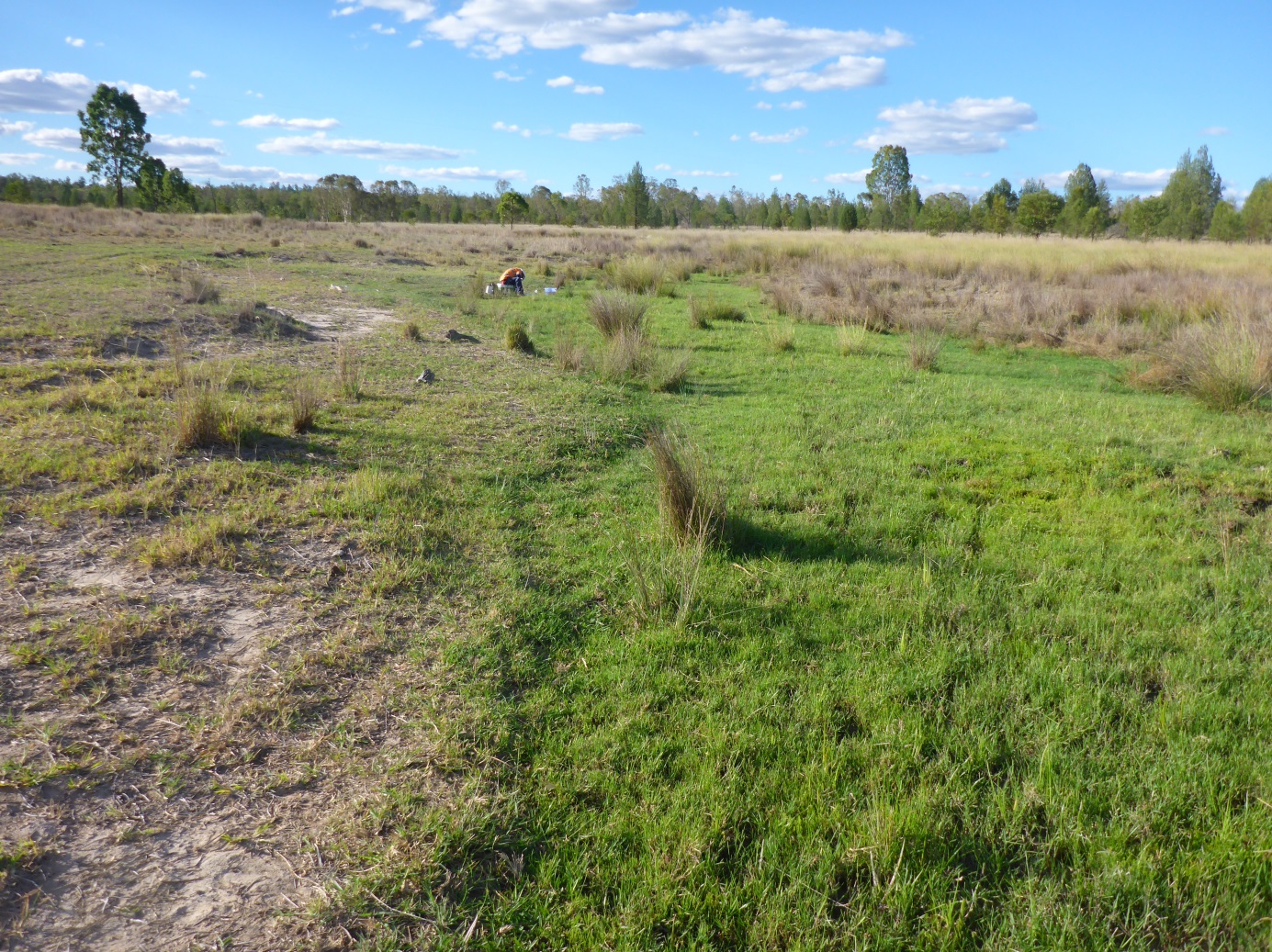
Spring ecosystems of the Surat and southern Bowen Basins—Type 5
Type 5
Examples of type 5 spring wetlands (Ponies complex)
Photo by Office of Groundwater Impact Assessment
Type 5 wetlands are similar to Type 4. However, the wetlands occur within upper catchment drainage lines that have ephemeral surface flow. Their location often coincides with the headwaters of large, more defined watercourses. The significant difference to Type 4 wetlands is that there is no distinct channel within the drainage line, such that the wetlands occur as broad areas of saturation within only minor wetland soil development.
Seasonal changes in the wetlands occur when seasonal recharge increases discharge to the wetland, increasing the wetted area and wetland discharge rate. This is in contrast to Type 4, where any increase in discharge flows directly into the adjacent watercourse with only minor change in wetland area.
The wetlands have formed due to a local groundwater flow system overlying a lower-permeability weathered substrate. Lateral gravity-driven flow paths result in point discharge zones (wetlands) within the valley floors. Four focal zones are described that represent the variability across the wetlands driven by the groundwater regime.
Permanent zone of groundwater discharge. Dominated by forbs such as Myriophyllum gracile, Eriocaulon scariosum, Philydrum lanuginosum, Utricularia dichotoma, the sedge Eleocharis cylindricus and other species indicative of permanent or near-permanent inundation.
Seasonal areas of groundwater discharge and saturation. These areas are more temporally inundated and dominated by the lawn Cynodon dactylon and other terrestrial species with some fluctuating encroachment from the adjacent wetland vegetation in Zone 1.
Adjacent bare areas dominated by a sparse cover of terrestrial grasses and sedges including Juncus spp., Eragrostis spp. and Bothriochloa bladhii.
Ceased flowing wetlands. During extended wet periods, wetlands can occur temporarily (for many years) higher in the landscape. However, during dry periods, the local watertable drops and the wetlands become disconnected from the groundwater system and cease physically discharge.
Queensland Government, Queensland (2017) Spring ecosystems of the Surat and southern Bowen Basins, WetlandInfo website, accessed 8 May 2025. Available at: https://wetlandinfo.des.qld.gov.au/wetlands/ecology/aquatic-ecosystems-natural/groundwater-dependent/spring-ecosystems-of-the-surat-and-southern-bowen-basins/


 — Department of the Environment, Tourism, Science and Innovation