

|
|
Terrain morphologyTerrain morphology describes the basic three-dimensional shape of that underpin the features of a landscape. Terrain morphology is one of several components that helps describe terrain and provides the fundamental units on which terrain can be spatially understood. There are a range of scales from regional morphology (e.g. continental, catchment ), through to habitat scale (e.g. river reach, beach ridge). The morphology of the surface can directly influence water movement (and energy), soil, physical and chemical properties, productivity and geomorphological processes[1][6][7][8].
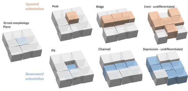
Morphological features can provide the structural complexity that creates many microhabitat types and increases biota diversity and abundance[4][3]. Channels and depressions are often high in structural complexity, providing conduits for water flow and currents. Different morphologies of the landscape can be biodiversity hotspots for fish and benthic infauna (e.g. filter feeders), providing corridors for mobile fauna. Terrain morphology can determine habitat connectivity - reducing or providing ongoing connections. There are three elements that characterise terrain morphology: (i) orientation and (ii) morphology units and (iii) morphology patterns. (i) Orientation describes whether the landscape unit it is ‘up’ ‘down’ or ‘flat’. Simple terrain morphology can be classified by its orientation. Automated tools for determining orientation from a digital terrain model include Topographic Position Index, an index between 1 (up), zero (planar) and -1 (down)[5]. Morphological units can be described using seven fundamental elements - plane, peak, pit, ridge, channel, crest and depression. In the figures above, each of the cubes represent a value of elevation relative to a plane in a digital terrain model. The colours represent their orientation i.e. grey for planar, brown for up, blue for down.
The terrain morphology of the landscape in Australia was largely influenced by tectonic earth movements and long term changes in sea level. The topography seen today is the result of prolonged erosion by wind and water[2]. Drainage patterns in a catchment, including river networks and branching complexity and the locations of wetlands are reflections of the terrain morphology. Terrain morphologies at multiple scales influence flow paths, patterns of water storage, hydrological connectivity and how long water remains in the landscape (such as wetlands). Natural depressions in the landscape, combined with the right underlying geology, can support wetlands where water remains for periods of time. Coastal wetlands form based on their proximity to the changing tides and sea level. Higher in the catchment, where terrain morphology forms peaks or mountains, water flow and accumulation differs from that of a floodplain area with a flatter morphology. The shape of the landscape also influences the speed at which water moves along it. The benthic terrain morphology of intertidal and subtidal wetland systems, usually derived from bathymetry surveys, provides foundational data for effective decision making in these areas. Links and referencesLandforms - Geoscience Australia Benthic Terrain Morphology (Intertidal and Subtidal) References
Last updated: 25 October 2023 This page should be cited as: Department of Environment, Science and Innovation, Queensland (2023) Terrain morphology, WetlandInfo website, accessed 8 May 2025. Available at: https://wetlandinfo.des.qld.gov.au/wetlands/ecology/components/terrain/terrain-component/ |

Site footer

 — Department of the Environment, Tourism, Science and Innovation