

|
|
Central Freshwater Biogeographic ProvinceCentral Freshwater Biogeographic Province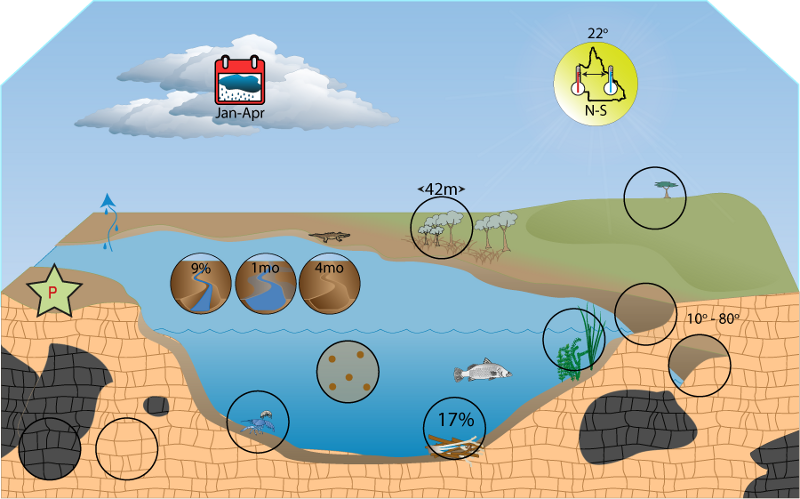 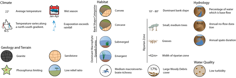 Click on elements of the model or select from the tabs below The Central Freshwater Biogeographic Province (FBP) is largely formed by the Burdekin and Fitzroy drainage basins to the west. Coastal drainage basins to the east include the Ross, Haughton, Don, Proserpine, O’Connell, Pioneer, Plane, Styx, Shoalwater, Waterpark, Curtis Island, Calliope, and Boyne. The FBP incorporates the Central Queensland Coast, Brigalow Belt, Desert Uplands and Einasleigh Uplands vegetation bioregions, and a very small portion of the South Eastern Queensland vegetation bioregion. Last updated: 22 March 2013 This page should be cited as: Department of Environment, Science and Innovation, Queensland (2013) Central Freshwater Biogeographic Province, WetlandInfo website, accessed 8 May 2025. Available at: https://wetlandinfo.des.qld.gov.au/wetlands/ecology/aquatic-ecosystems-natural/riverine/freshwater-biogeo/central/ |
Site footer

 — Department of the Environment, Tourism, Science and Innovation