

|
|
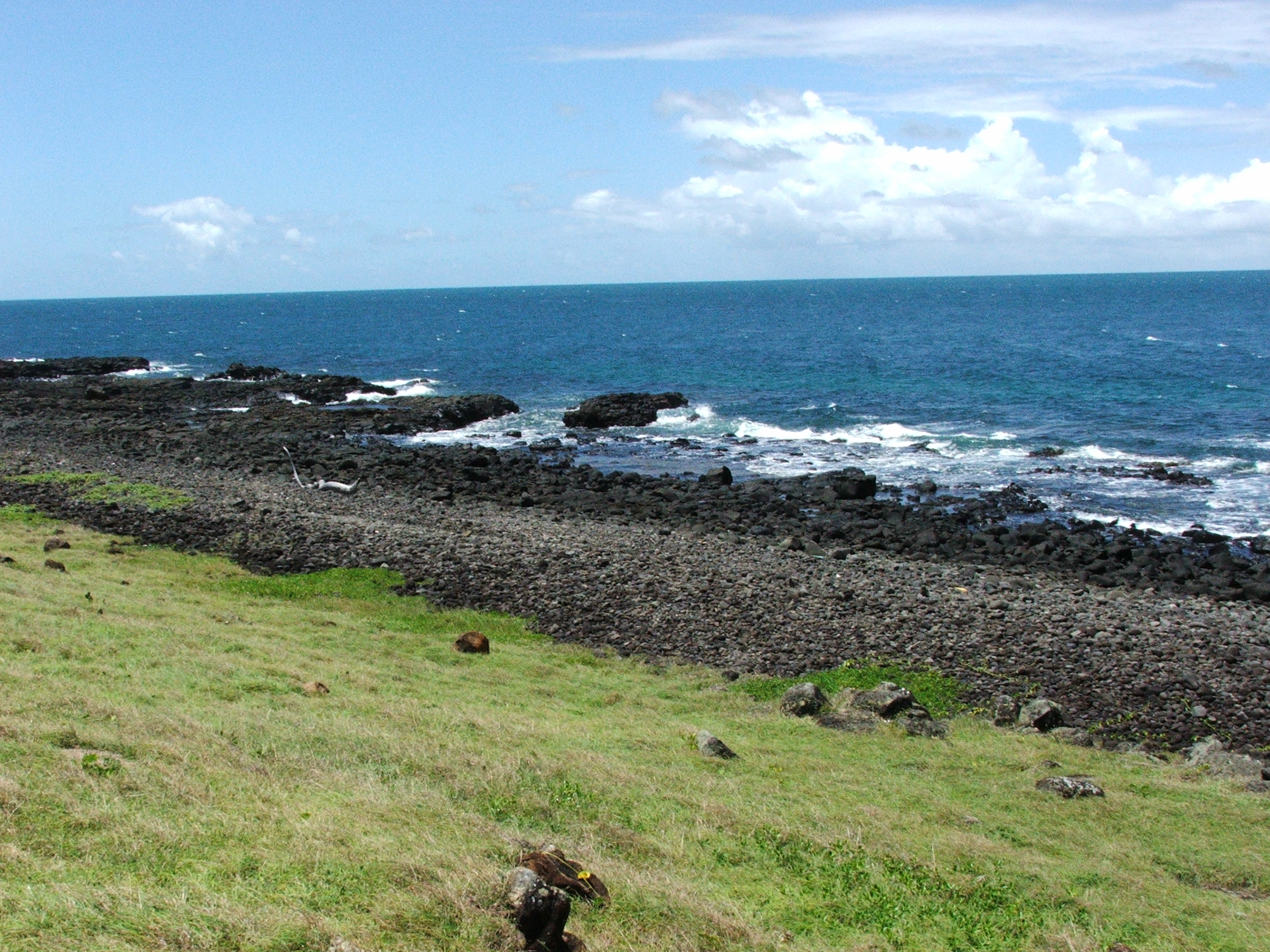
Substrate grain sizeWhile substrate grain size is frequently correlated with energy magnitude (e.g. boulders and cobbles on high energy shorelines) it may also be an artefact of previous processes that no longer occur such as relics of different shorelines or the product of erosion of sedimentary rocks with mixed grain sizes (e.g. conglomerates, duricrusts etc.). Quick facts
Substrate grain size of unconsolidated substrates is important for a variety of reasons. Subtidal muds and silts may be fine enough to become suspended in the water column, if the energy is sufficient at the sea floor to keep them in suspension. These suspended sediments can decrease water clarity resulting in insufficient light for photosynthesis by corals and seagrasses[2]. Sediment disturbances can be broad ranging, influencing particular taxonomic groups, life-history characteristics and habitat types, which is why an ecosystem-based approach is advocated to account for impacts of sediments[5]. Refer to Substrate Composition (terrigenous) for further discussion, including initiatives to address reducing sediment runoff impacts from the land. Sands drain quickly and may act as a groundwater ‘sponge’ (see coastal sand mass conceptual model). Gravels and boulders increase the rugosity or structural complexity of the substrate, providing three-dimensional structure for biota to attach[6]. Spaces beneath gravel and boulders provide shelter and retain seawater for animals dependent on it in the intertidal area[1]. Gravels and boulders are less mobile, but even very large boulders during high-energy storms and cyclones[7]. The substrate grain size attribute applies to unconsolidated non-living substrates of the sea floor (also known as sediments). There are several ways to classify substrate grain size. The Udden-Wentworth Scale[8] classifies substrate grain size into diameters of increasing sizes, listed below in the Attribute Category Table for Substrate Grain size. Equivalent codes to these grain sizes are also provided by the Collaborative and Annotation Tools for Analysis of Marine Imagery and Video (CATAMI) classification scheme and the Marine Nature Conservation Review (MNCR). In the field, sediments seldom occur in a pure form, appearing as mixtures that can be typed or grouped in different ways. The Folk classification is based on the grain size classes of the Udden-Wentworth Scale[8], reclassified and compared in a typology that is further described below. Queensland Intertidal and Subtidal Classification SchemeSubstrate grain size falls under the 'Substrate' theme of attributes for the Intertidal and Subtidal Classification Scheme. It categorises the size of unconsolidated substrates (regardless of composition). The size classes used are those used in the Udden-Wentworth Scale[8]. The sediment texture typology is often easier to map than each separate grain size. Attribute Category Table - Substrate Grain Size
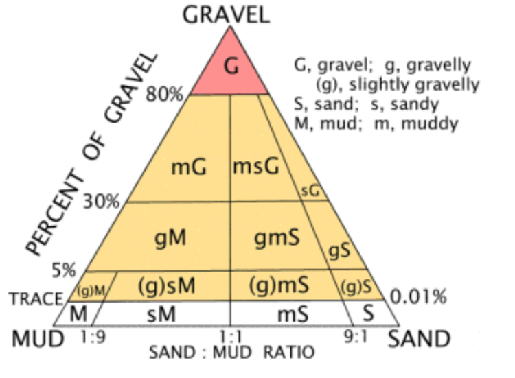
Sediment Texture Typology (Folk)
Recognising that substrates generally occur in mixtures of grain sizes, a practical application to describe sediments in their mixed form is the Folk typology[3]. The Folk typology is frequently applied in other seabed classifications such as the European Nature Information System (EUNIS), and has been used to harmonise and collate seabed substrate data for European maritime areas[4]. Originally designed to classify the grain size of sedimentary rocks, Folk codes summarise sediment textures in terms of percent mud, sand and gravel fractions. ‘Sediment texture’ is the term used to describe the proportions of sand, gravel and mud as defined by the Udden-Wentworth scale[8] (as in the Attribute Category table for Substrate Grain Size, seascape scale column). The Udden-Wentworth’s sand and mud sediment grain sizes are used to define each of two of the three axes of the triangle that defines proportions or mixtures of Folk sediment texture typology (see right). ‘Gravel’ comprises the third axis of the ternary diagram, constituting a grouping of the Uden-Wentworth ‘pebbles’ ‘cobbles’ and ‘boulders’. Sometimes ‘boulders’ are split out separately from the Folk typology and mapped separately. The notation for the Folk figure is that the dominant grain size (primary) is capitalized, the subdominant (fractional) is lower case, and the next subdominant (slight fraction) is in brackets, for example ‘(g)sM’ represents ‘(slightly gravelly) sandy MUD’[3]. The sediment texture typology is often easier to map than each separate grain size, as a dominant grain size may overlap with other subdominant grain sizes and boundaries may differ. For this reason, the Folk typology is frequently applied in other seabed classifications such as the European Nature Information System (EUNIS), where it has been used to harmonise and collate seabed substrate data for European maritime areas. For the substrate grain size attribute, the Sediment texture (Folk) typology was also chosen to harmonise different seabed grain sizes in the Central Queensland intertidal and subtidal ecosystems classification, typology and mapping.
Additional Information
References
Last updated: 23 July 2019 This page should be cited as: Department of Environment, Science and Innovation, Queensland (2019) Substrate grain size, WetlandInfo website, accessed 25 June 2024. Available at: https://wetlandinfo.des.qld.gov.au/wetlands/ecology/aquatic-ecosystems-natural/estuarine-marine/itst/substrate-grain-size/ |
|||||||||||||||||||||||||||||||||||||||||||||||||||||||||||||||||||||||||||||||||||||||||
Site footer

 — Department of Environment, Science and Innovation