

|
|
Terrain slope Quick facts
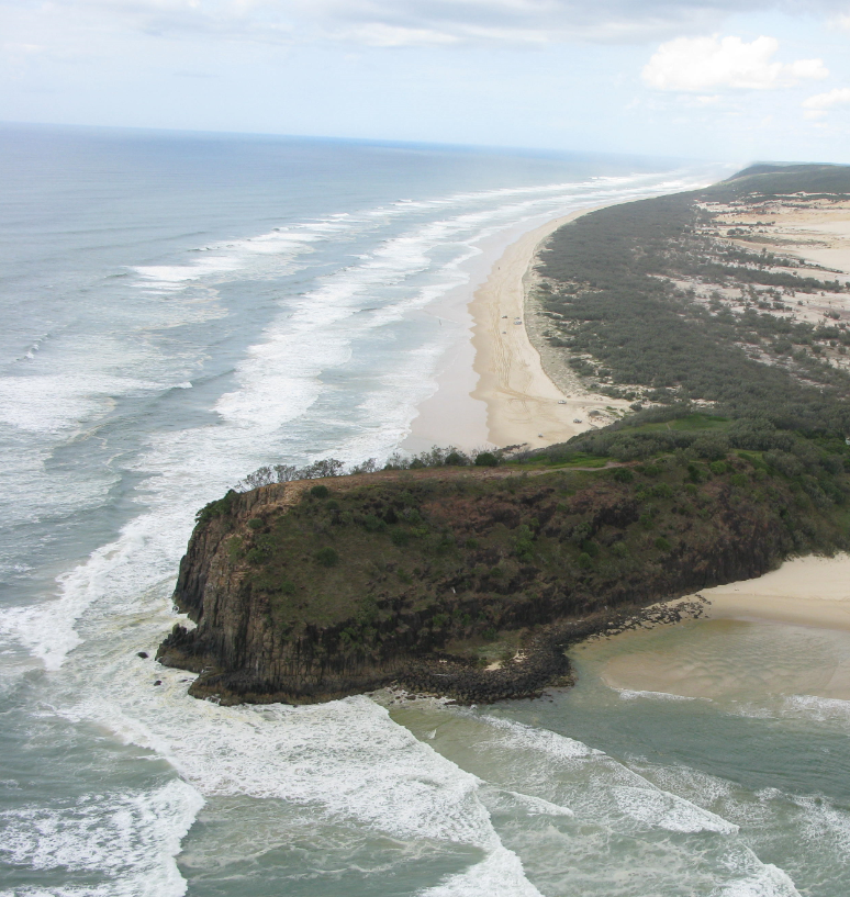
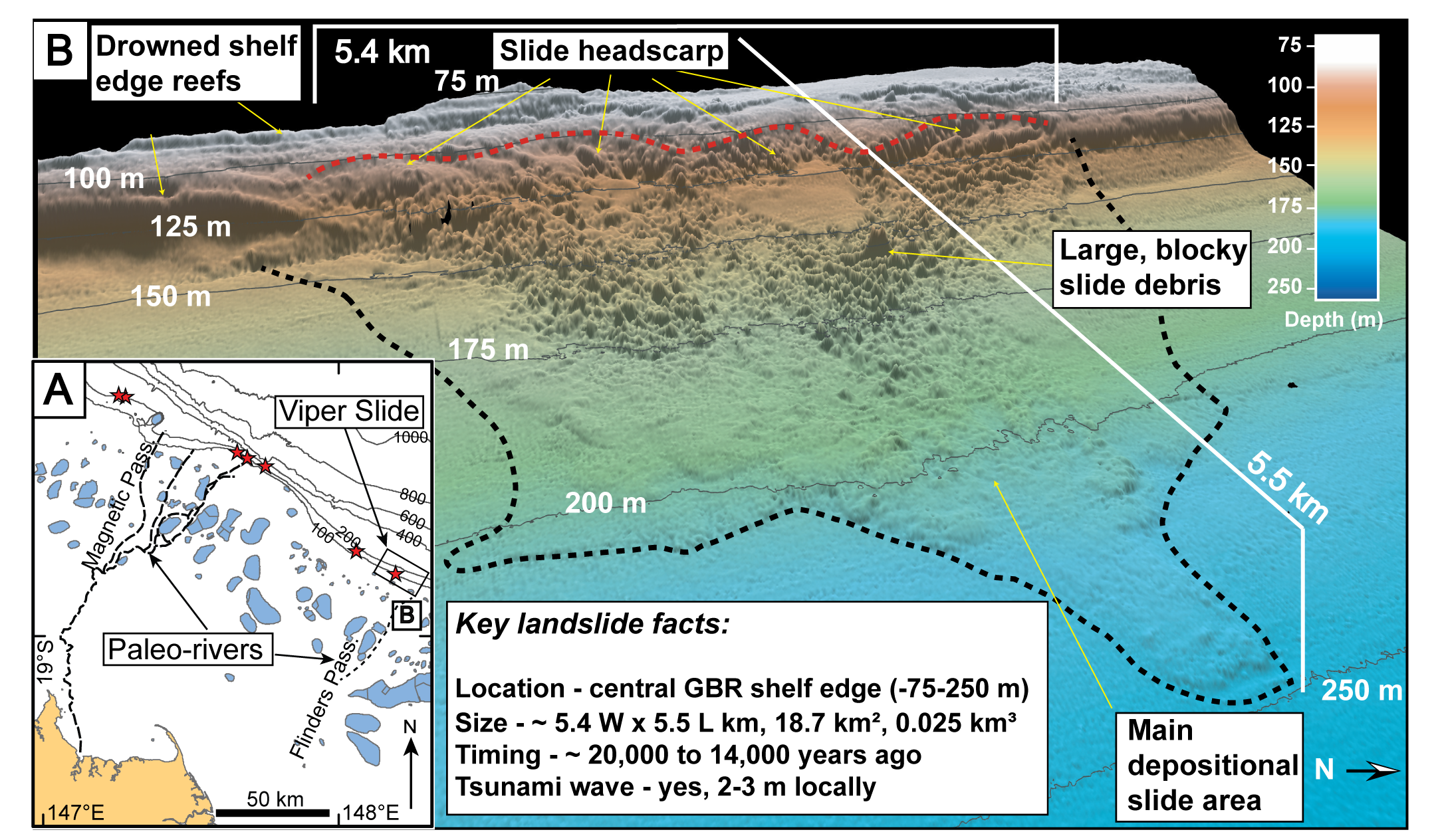
Why is terrain slope important?Slope is frequently used in combination with other terrain attributes such as benthic depth, roughness, and morphology to classify and allocate types to morphological features of the sea floor and their structural macrobiota[11]. The term slope can be applied to describe a morphological feature, e.g. the ‘shelf break’ is a very steep slope at the edge of the continental shelf, and beyond it the ‘continental slope’ marks a less steeply inclined area between the shelf break and abyssal plain (gently inclined or flat). On land and intertidally, under the force of gravity, water moves from higher to lower elevation, transporting sediment and dissolved material. Its rate of movement is determined by a number of factors including the terrain slope, as the water will flow faster the steeper the slope, and the roughness of the terrain[5]. The speed and rate at which water moves through the terrain has implications for erosion, deposition, drainage and runoff, infiltration, and a range of other hydrological processes[18]. Sediment is transported by gravity, wind, wave, tidal and other current action and slope influences the rate at which this happens. On land, the rate of soil loss is proportionate to the steepness and length of a slope[23][26]. Steep terrain slopes are commonly encountered in subtidal areas, as the effects of gravity are lessened by the buoyancy of water counteracting the gravitational force (Archimedes’ Principle). The energy of the water interacts with the terrain, driving geomorphological and hydrological processes[24]. Riverine, wave and tidal currents are capable of modifying terrain slopes and displacing sediment to form cliffs, channels, caverns and dunes[25]. In the intertidal area, the steepness of the beach face is an important attribute in coastal morphodynamic research, being related to hydrodynamic energy, grain size, and tidal range[20]. When manually delineating morphological features it is often easier to distinguish the features based on the rate of change of the slope e.g. the slope of the slope. For example rapid changes in slope mark the tops and sides of ridges, edges of channels and pits (terrain morphology). Changes in slope at different scales inform the characterisation of morphological features, benthic habitat types and geomorphological processes, from the habitat scale (e.g. coffee rock ledges) to the regional scale (e.g. the shelf break). Rapid changes of slope may originate from differences in substrate (e.g. consolidated substrates such as reefs), energy sources and magnitudes (e.g. wave-cut platforms, riverine eroded channels), and/or indicate different sea level histories and associated geomorphological processes of erosion and deposition. ‘Reef slope’ is the steepest part of the seaward section of a coral reef[8]. On a coral reef, the shallow reef slope is frequently the standard location for surveying representative areas of coral cover as an indicator of active coral reef building (e.g. Van Woesik and Done[19]). The elevation of coral reefs can be a marker of the current and previous position of sea levels over the last 20,000 years. Some reefs drowned, while others kept pace with sea level rise[22][8]. Very steep slopes of unconsolidated substrates may result in undersea landslides, forming similar morphological structures seen on land (e.g. fans) and even result in tsunamis capable of having far reaching effects on shorelines. Submarine landslides that occur on slopes are capable of transporting vast amounts of sediment from the continental shelf to the deep sea floor, even changing continental margins[21].
Modifed after Webster[21]
Often the steepest sloping terrains are consolidated, providing substrate for biota to attach. Steep canyon walls are hotspots of biodiversity, due to internal waves that move between the different density layers along the shelf edges breaking against them, resuspending and concentrating food particles for heterotrophic benthic animals to feed[15]. The steepness of the slope of a morphological feature correlates with the distribution of different benthic communities and may delineate the boundaries of that feature[17][1]. Changes in slopes are often used to delineate boundaries of morphological features, e.g. channels and depressions at a range of scales, for example tidal channels visible at the habitat scale through to seascape scale passages and drowned river valleys on the continental shelf. A good example of the importance of slope can be seen in biotic differences that characterise certain reefs with different terrain slopes. Steeply sloping mesophotic reefs receive some protection from sediment raining down from above, and are characterised as distinctly different ecosystems inhabited by different, more diverse taxa than that of adjacent flat-topped mesophotic reefs[4]. Changes in slope on the edge of the continental shelf reveal terraces that represent previous sea levels and associated fringing reef growth (now mesophotic reefs) that align with interglacial rises and falls in sea levels[4][3][13][22]. Measuring terrain slopeTraditionally slope was surveyed across shorelines using a tape, stick and level (e.g. dumpy level). Slope can be measured a number of different ways: (i) degrees, (ii) percentage, or (iii) geometrically as a tangent ratio, expressed as the change in elevation vertically over the change in elevation horizontally (e.g. 1 in 10[18][5]). It is difficult to generalise on slope thresholds, as they are dependent on the scale of measurement, and thus relevant slope thresholds for marine and intertidal environment are difficult to find within the literature. Terrestrial slope thresholds relate to landform, geomorphological and soil formation processes, also relevant to the intertidal area[22]. Slope is used in digital soil process modelling, catchment delineation, hydrological surface flow and other terrain modelling, forming the basis for many topographic derivatives[12][9]. It is possible to calculate slope based on digital terrain models derived from remote sensing methods e.g. intertidally using LiDAR and drones, subtidally with satellite derived bathymetry, sonar and light ranging method such as bathymetric LiDAR. Metrics of slope may be derived from digital terrain models in a number of different ways[10]. Slope variability can be sampled statistically within a given area or analysis window, calculating average or mean, or standard deviation when modelling terrain attributes[7]. Increasing ruggedness or topographic complexity results in greater variability in slope, in which case other attributes (and metrics) which consider local variation provide more information about the terrain[10]. Queensland Intertidal and Subtidal Classification SchemeThe slope categories of seascape and habitat in the Intertidal and Subtidal Classification Scheme and their thresholds (see table below) are directly based on Speight’s landform pattern and element (scales) respectively and the thresholds in degrees, percentage and tangent are similar to Table 2 of the Australian Soil and Land Survey Field Handbook[18][14]. Within the intertidal and subtidal zones, slope categories or resolution of categories are different – appropriately dealt with via typologies applied to the attributes.
Suggest thresholds for slope are: Level (<= 0°35') Very gently inclined – 1 (0°35' - 1°) Very gently inclined – 2 (1° - 1°45') Gently inclined - 1 (1°45' - 3°15') Gently inclined - 2 (3°15' - 5°45') Moderately inclined - 1 (5°45' - 10°15') Moderately inclined - 2 (10°15' - 18°) Steep (18° - 30°) Very steep (30° - 45°) Precipitous (45° - 72°) Cliffed (> 72°) (these values are applicable for the habitat level. For higher levels the thresholds would be grouped as per the categories shown in the preceding table) References
Last updated: 22 July 2020 This page should be cited as: Department of Environment, Science and Innovation, Queensland (2020) Terrain slope, WetlandInfo website, accessed 8 May 2025. Available at: https://wetlandinfo.des.qld.gov.au/wetlands/ecology/aquatic-ecosystems-natural/estuarine-marine/itst/terrain-slope/ |

Site footer

 — Department of the Environment, Tourism, Science and Innovation