Skip links and keyboard navigation

Petrie Formation along the shoreline of Moreton Bay

Petrie Formation along the shoreline of Moreton Bay

Subterranean GDEs Acacia spp Evaportranspiration Evaportranspiration Corymbia spp Acacia spp Corymbia spp Eleocharis spp Cladium spp Cladium spp Cladium spp Cladium spp Fish Direction of groundwater movement Fresh groundwater and saline marine water interface Fresh groundwater and saline marine water interface Direction of marine water movement Direction of groundwater movement Hydrology Direction of groundwater movement Negligible water movement Direction of groundwater movement Hydrology Infiltration and percolation Negligible water movement Surface expression GDEs (near shore marine systems) Terrestrial GDEs Surface expression GDEs (estuarine systems) Surface expression GDEs Terrestrial GDEs Terrestrial GDEs Infiltration and percolation Dugong Geology Groundwater table Acacia spp Eucalypt spp Cladium spp Corymbia spp Evaportranspiration Corymbia spp Eucalypt spp Acacia spp Melaleuca and Eucalyptus spp Corymbia and Eucalyptus spp Mangrove spp Seagrass Basement Basement Sandstone saturated with fresh groundwater Sandstone saturated with saline marine water Basalt saturated with fresh groundwater Basalt saturated ith saline marine water Basalt unsaturated Basalt unsaturated Sandstone Cloud and rainfall

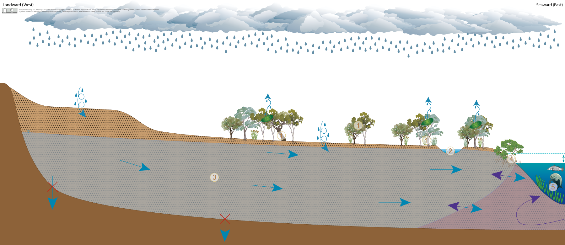
Click on elements of the model or select from the tabs below

Weathered basalt of the Petrie Formation in coastal areas (Redland basalt) is moderately to highly permeable and may form aquifers which store and transmit groundwater through vesicles, fractures and weathered zones. Vertical groundwater movement from a basalt aquifer is often restricted by underlying unweathered bedrock which may have lower permeability. While groundwater will often continue to leak through the less permeable rock to some degree, typically groundwater moves laterally and can be discharged to the surface or offshore along the contact between weathered basalt and underlying less permeable rocks. Where deeply weathered Petrie basalt occurs along the shoreline of Moreton Bay it usually supports a shallow water table, and groundwater often discharges into near-shore marine environments of Moreton Bay.

A range of ecosystems may depend on groundwater within these unconfined, basalt aquifers to support their plant and animal communities, ecological processes and delivery of ecosystem services:

  • Palustrine (e.g. swamps) and lacustrine (e.g. lakes) wetlands and riverine (e.g. streams and rivers) water bodies may depend on the surface expression of groundwater resulting from very shallow water tables within these weathered rock aquifers.
  • Terrestrial vegetation may depend on the subsurface presence of groundwater in these weathered rock aquifers where groundwater is typically accessed through the capillary zone above the water table.
  • Weathered rock aquifers may also support ecosystems within the aquifer itself, which sometimes is indicated by the presence of stygofauna.

Pictorial conceptual model PDF


Last updated: 18 December 2015

This page should be cited as:

Queensland Government, Queensland (2015) Petrie Formation along the shoreline of Moreton Bay, WetlandInfo website, accessed 18 March 2024. Available at: https://wetlandinfo.des.qld.gov.au/wetlands/ecology/aquatic-ecosystems-natural/groundwater-dependent/petrie-formation-along-the-shoreline-of-moreton-bay/

Queensland Government
WetlandInfo   —   Department of Environment, Science and Innovation