

|
|
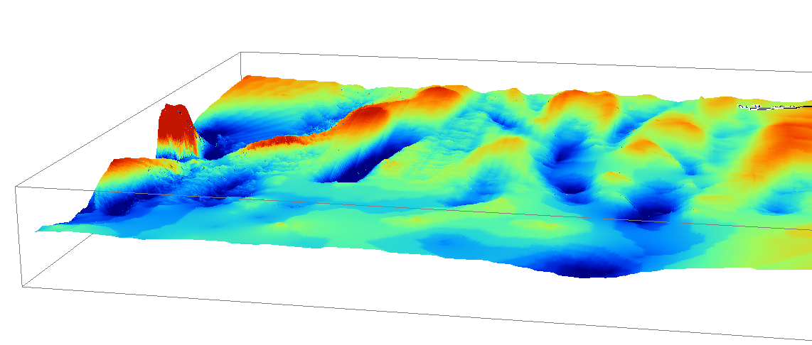
Terrain relative reliefTerrain relief is the difference in elevation between the high and low points of a land surface[8], that is, the change in the height of the ground over the area[10]. Terrain relative relief (or elevation) is the relative difference in elevation between a morphological feature and those features surrounding it (e.g. height difference between a peak and surrounding peaks, a depression and surrounding depressions etc.). Together with terrain morphology, and other terrain attributes, it is useful for describing how the terrain affects intertidal and subtidal processes.
Quick facts
Why is terrain relative relief important?On land, the context of a feature within the landform and its surroundings has implication for soil characterisation and associated geomorphological processes. Terrain relative relief is scale-dependent, being derived from elevation of the terrain feature at a finer scale than the scale at which it is reported. In digital soils mapping and modelling, relative elevation or relief is a secondary terrain derivative metric diagnostic of soil processes associated with water running through the landscape (along with slope, morphology etc. – see McBratney[7]). Terrain relative relief is important in the intertidal and subtidal environment for both biodiversity and underlying geomorphology. Specific faunal groups may require specific thresholds, for example variations in vertical relief (within a window of 75m) was the best abiotic surrogate to explain abundance, diversity and community composition of temperate rocky reef biodiversity[12]. Microrelief was a significant factor for seagrass annual colonisation, that is, the seagrass in the hollows had longer shoots and greater above ground biomass[9].
Riverine, wave, tidal and ocean current energy sources interact with the ups and downs of the sea floor terrain, modifying hydrodynamics, and the movement of materials and biota[14][1]. High relief undersea features such as seamounts and submerged reefs create upwellings by displacing currents toward the surface, creating eddies that concentrate food and enhance water column productivity and benthic biomass and attract pelagic fish[3][2]. Artificial reefs are human-made structures that mimic these features. They are installed for a range of social-economic benefits including attracting fish, increasing fish production, tourism (fishing hotspots, surfing and dive sites) and engineering applications such as beach erosion control[5]. Relief is useful for understanding abiotic substrates. Relief metrics are used to identify sinkholes in subtidal karst[11]. Relative amplitude of unconsolidated bed forms reflects water column energy or hydrodynamic forcing, for example, the amplitude of intertidal bars on high energy beaches responds to tidal flows, waves and storms[6]. Understanding the relative relief of sandwaves is important for understanding sediment mobility for the positioning of buried undersea cables to ensure they remain beneath the substrate, safe from trawl or anchor damage. Based on their relative elevation and wavelength (distance between repeating features), peaks were either classified as ripples, megaripples, sand waves or sandbanks and the degrees to which they moved over time was able to be characterised. Measuring terrain relative reliefLand-based relief classes at a subregional scale (and descriptive geomorphological features typically displaying these reliefs) include: Very high >300m (e.g. mountains, volcanos); High 90-300m (e.g. hills including volcanos, calderas, craters); Low 30-90m (e.g. low hills); Very low 9-30m (e.g. rises including terraces, dunefields, coral reefs, peneplains); Extremely low <9m (e.g. plains including pediment, meander, floodplain, delta, tidal flat, beach ridge plain, chenier, sand plain. On land, relative relief classes can be indicative of vulnerability to erosion. In the intertidal and subtidal environment, similar relief classes to those listed above, applying similar principles with hierarchical data informing different scales, i.e. deriving higher level information from a lower level. Height thresholds differ from land-based thresholds due to different dynamics of erosion and deposition, for example the influence of the four-dimensional water column rather than the chemical and physical processes of air, substrate, gravity and freshwater flows. A digital terrain model can be used to derive metrics of terrain relief. Thresholds for categories will be defined based on the index used, usually derived from a digital bathymetric model or digital elevation model, with consideration of scale and purpose of the classification. The Bathymetric Position Index (BPI) measures the elevation of a location with respect to that of its surrounding terrain, resembling the topographic position index (TPI) of terrestrial terrains[15]. The mean elevation or depth within a short radius of a specific point is compared with the mean elevation or depth of the bigger surrounding area, i.e. a buffered area surrounding the point or pixel. It can be integrated into mapping workflows of benthic terrain using toolsets such as the ArcGIS Benthic Terrain Modeller[13]. Queensland Intertidal and Subtidal Ecosystem Classification SchemeThe terrain relative relief categories of seascape and habitat in the Intertidal and Subtidal Ecosystem Classification Scheme (Table below) reflect Speight’s landform pattern and element (scales) of the Australian Soil and Land Survey Field Handbook. Being relative, the categories will reflect the range of available elevations of morphological features within a sampled area (refer to those listed in the definition). A range of features of various elevations within a sampled area will need to be categorised into higher differences in elevation versus lower differences in elevation.
References
Last updated: 22 July 2020 This page should be cited as: Department of Environment, Science and Innovation, Queensland (2020) Terrain relative relief, WetlandInfo website, accessed 8 May 2025. Available at: https://wetlandinfo.des.qld.gov.au/wetlands/ecology/aquatic-ecosystems-natural/estuarine-marine/itst/terrain-rel-relief/ |

Site footer

 — Department of the Environment, Tourism, Science and Innovation