

|
|
South-East Freshwater Biogeographic ProvinceSouth-East Freshwater Biogeographic Province – Water quality 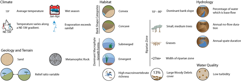 Click on elements of the model or select from the tabs below TurbidityTurbidity within the South-East FBP is generally very low. Low turbidity typical of the South-East FBP means that in the absence of riparian shading, light penetration through the water column will be high and is not likely to be a limiting factor for benthic algal primary production, or for aquatic macrophtye growth.
Information about primary productivity and light climate
Last updated: 22 March 2013 This page should be cited as: Department of Environment, Science and Innovation, Queensland (2013) South-East Freshwater Biogeographic Province – Water quality, WetlandInfo website, accessed 8 May 2025. Available at: https://wetlandinfo.des.qld.gov.au/wetlands/ecology/aquatic-ecosystems-natural/riverine/freshwater-biogeo/south-east/water-quality.html |
Site footer

 — Department of the Environment, Tourism, Science and Innovation