

|
|
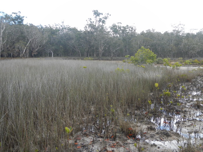
SedgeShort descriptionTidal vegetation dominated by sedges and grasses. Disclaimer: Ecosystem type descriptions are based on biophysical attributes identified in Central Queensland through expert advice and supported by scientific literature. Not all ecosystem types are mapped based on current inventory, and many of the ecosystems described here may also occur in other parts of Queensland.
Classification categoriesSelect from the links below to view related ecosystem type categories Long descriptionSedgelands dominated by a range of sedges and grasses including Eleocharis philippinensis, Cyperus alopecuroides, Cyperus scariosus and Cyperus iria and the grasses Sporobolus virginicus and Paspalum vaginatum. The sedges Fimbristylis ferruginea, Phyla nodiflora and Cyperus polystachyos var. polystachyos may occur in the shallower margins, together with Vincetoxicum carnosum. Cyperus polystachyos, Gymnanthera oblonga, Acrostichum speciosum and Centella asiatica in the transition zone between tidal and freshwater areas. These systems occur in depressions on Quaternary estuarine deposits that are brackish to saline[4] These ecosystems tend to be associated with more freshwater (surface or ground) influence, for example at the landward edge of saltpans and/or on sandier soils where groundwater permeates (such as the upper beach where there is groundwater expression). May be seasonally inundated with freshwater, but dry out completely between rain events. Seaward extent and frequency of tidal inundation depends on freshwater influence (rainfall, groundwater) but can be low in the system and therefore inundated regularly. Strips of sedges occur low down in the tidal area on Fraser Island west coast beaches where groundwater is coming to the surface. Special valuesCan provide habitat for the water mouse (Xeromys myoides), which is Environment Protection and Biodiversity Conservation Act 1999-listed (EPBC-listed). This species has been recorded from coastal saltmarsh ecosystems including saline sedgelands and grasslands, succulent shrublands, mangroves and freshwater wetlands. Water mice are known to hunt amongst mangrove pneumatophores and in shallow pools, for grapsid crabs and other intertidal crustaceans, pulmonate snails and marine gastropods[5]. Habitat for a range of waders and water birds, many of which are EPBC-listed. May contain pools and often holds back estuarine water in the pools when tide recedes, which are important fish and crustacean nurseries. Marsh crabs are common in sedgelands. Diagnostic attributesInundation 'Intertidal - Lower low’, ‘Intertidal – Mid low’, ‘Intertidal – Upper low’, ‘Intertidal – Low undifferentiated’, ‘Intertidal – Lower medium’, ‘Intertidal – Upper-medium’, ‘Intertidal – Medium undifferentiated’, ‘Intertidal – High’, ‘Intertidal – Undifferentiated’, ‘Intertidal – High undifferentiated’ (although they occur closer to the higher tidal planes which remain unmapped) Structural macrobiota ('Sedge') QualifiersThe Naturalness qualifier is relevant as tidal inundation may sometimes be modified by barriers, and excavated channels, modifying Inundation and Terrain morphology. Changes in tidal inundation will be reflected by changes in Structural macrobiota. These ecosystems fluctuate in extent over time and relevant qualifiers are Period and Trend. Changing tidal inundation due to sea level rise is causing mangroves to colonise saltmarsh ecosystems (list their numbers)[2]. DistributionSedge ecosystems are potentially common associated with areas of freshwater/groundwater expression, e.g. melaleuca swamps and large sand systems, such as from Fraser Island southward (Cooloola, Bribie, Moreton and Stradbroke Islands). The following relates to distribution of this ecosystem type within the Central Queensland mapping area:
CommentsOther relevant attributes include Freshwater input source, Freshwater input volume, Consolidation, Energy and Sediment texture as sedges typically grow on unconsolidated muds and fine sediments in low energy environments. Additional informationField Guide to common saltmarsh plants of Queensland
References
Last updated: 19 July 2019 This page should be cited as: Department of Environment, Science and Innovation, Queensland (2019) Sedge, WetlandInfo website, accessed 8 May 2025. Available at: https://wetlandinfo.des.qld.gov.au/wetlands/ecology/aquatic-ecosystems-natural/estuarine-marine/descriptions/4/ |
Site footer

 — Department of the Environment, Tourism, Science and Innovation