

|
|
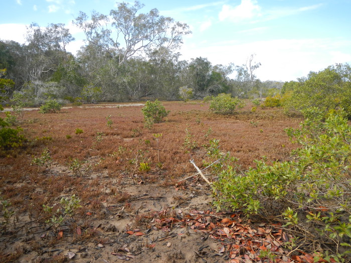
Grass herb sedge undifferentiatedShort descriptionSaltpan communities with or without vegetation such as succulents, herbs, sedges, grasses and/or algae. Disclaimer: Ecosystem type descriptions are based on biophysical attributes identified in Central Queensland through expert advice and supported by scientific literature. Not all ecosystem types are mapped based on current inventory, and many of the ecosystems described here may also occur in other parts of Queensland.
Classification categoriesSelect from the links below to view related ecosystem type categories Long descriptionSaltpan communities with or without vegetation such as succulents, herbs, sedges, grasses and/or algae, which are typically adjacent to mangrove communities. Landward parts of these communities are typically inundated rarely (i.e. the highest spring tides) and can become hypersaline, with more seaward parts inundated more frequently. Can be covered with mats of benthic microalgae (BMA) include channels and pools, and elevated areas that are more likely to be vegetated. Vegetation is generally zoned with succulent and herbaceous plants along the landward edge of the intertidal zone (e.g. Suaeda australis, Sarcocornia quinqueflora, Suaeda arbusculoides, Sesuvium portulacastrum, Tecticornia spp. and Salsola australis), which is then lined with grasses (e.g. Sporobolus virginicus and Paspalum vaginatum), and then sedges in areas with more freshwater (ground or surface) influence (e.g. Eleocharis philippinensis, Cyperus alopecuroides, Cyperus scariosus and Cyperus iria)[7]. Special valuesImportant fisheries habitat that can provide for feeding, growth and reproduction. Vegetated and non-vegetated saltpan ecosystems are used by a high number and diversity of fishes and many of economic importance, particularly in association with intertidal mangrove-lined creeks[7]. Can provide habitat for the water mouse (Xeromys myoides). This species has been recorded from coastal saltmarsh ecosystems including succulent shrublands, saline sedgelands and grasslands, mangroves and freshwater wetlands. Water mice are known to hunt amongst mangrove pneumatophores and in shallow pools, for grapsid crabs and other intertidal crustaceans, pulmonate snails and marine gastropods. These species are common in succulent and herbaceous saltmarsh ecosystems[8]. Saltpan communities with and without vegetation provide important fisheries habitat. Unvegetated saltpan adjacent to coastal wetlands provide feeding areas for high value fisheries species. Fish (such as sand whiting, yellow fin bream, threadfin salmon and flathead) feed on benthic crustaceans, bivalve molluscs and polychaete worms that are abundant in these bare areas[1]. Potential feeding areas and roosting areas for shorebirds provided by the habitat complex of bare areas adjacent to mangroves. Different species feed and roost in different habitat units of the complex. May contain pools, and often holds back estuarine water in the pools when tide recedes, which provide important fish and crustacean nurseries. BMA provides food for fishes, crustaceans, molluscs and other invertebrates. Breaking the BMA mat or crust (e.g. motorbikes and 4WDs) can damage the ecology of the area and bring about erosion, and it may take a long time to restore. Fiddler and marsh crabs feed in these ecosystems following inundated by rainfall or tide, and shelter in burrows at other times. Vegetated saltpan areas are generally inundated by the tide less frequently than mangroves, and these systems are under threat from sea level rise along seaward margins[7]. Sporobolus virginicus grasslands create ‘jump-ups’ by accumulating land through self-made detritus that builds up to elevate the level of the substrate. Stabilises intertidal area and creek banks and can trap terrestrial run-off/sediment. Environment Protection and Biodiversity Conservation Act (1999)-listed ecosystem. Diagnostic attributesInundation 'Intertidal – Lower low', 'Intertidal – Mid low', 'Intertidal – Upper low', 'Intertidal – Low undifferentiated', 'Intertidal – Lower medium', 'Intertidal – Upper-medium', 'Intertidal – Medium undifferentiated', 'Intertidal – High', 'Intertidal – Undifferentiated', 'Intertidal – High undifferentiated' although they occur closer to the higher tidal planes which remain unmapped Structural macrobiota 'Grass-herb-sedge (undifferentiated)' QualifiersThe naturalness qualifier is relevant as tidal inundation may sometimes be modified by infilling and reclamation, barriers, and excavated channels, modifying inundation and terrain morphology. Changes in tidal inundation will be reflected by changes in structural macrobiota (e.g. loss of BMA). Presence of other landuses and changes in hydrology may modify the attributes of this ecosystem type e.g. the presence of BMA. Breaking the BMA mat or crust (e.g. motorbikes and 4WDs) can damage the ecology of the area and bring about erosion, and it may take a long time to restore. These ecosystems fluctuate in extent over time and relevant qualifiers are Period and Trend. Changing tidal inundation due to sea level rise is causing mangroves to colonise the saltmarsh ecosystems[5]. DistributionSaltmarshes occur discontinuously along the entire coastline of Queensland and represent more than a third of the total saltmarsh area in Australia. Saltmarsh ecosystems are often narrower where rainfall is high or spread through the year, and broader in extent where rainfall is relatively low or where there is a severe dry season. Plant species diversity generally increases with increasing latitude (i.e. saltmarshes are more diverse in temperate systems than tropical systems), as opposed to mangroves, which are more diverse in tropical systems[6][4][3]. Some of the largest saltmarshes in Queensland include:
The following relates to distribution of this ecosystem type within the Central Queensland mapping area:
CommentsOther relevant attributes include Freshwater input source, Freshwater input volume, Consolidation, Energy and Sediment texture as saltpan communities typically occur on unconsolidated muds and fine sediments in low energy environments. Additional informationField Guide to common saltmarsh plants of Queensland References
Last updated: 18 July 2019 This page should be cited as: Department of Environment, Science and Innovation, Queensland (2019) Grass herb sedge undifferentiated, WetlandInfo website, accessed 8 May 2025. Available at: https://wetlandinfo.des.qld.gov.au/wetlands/ecology/aquatic-ecosystems-natural/estuarine-marine/descriptions/1/ |
Site footer

 — Department of the Environment, Tourism, Science and Innovation