

|
|
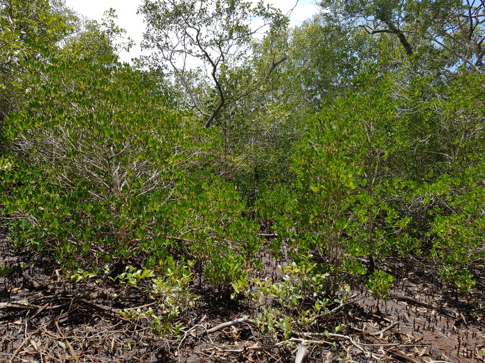
Ceriops-dominated mangrovesShort descriptionMangrove forest dominated by Ceriops australis or Ceriops tagal. Disclaimer: Ecosystem type descriptions are based on biophysical attributes identified in Central Queensland through expert advice and supported by scientific literature. Not all ecosystem types are mapped based on current inventory, and many of the ecosystems described here may also occur in other parts of Queensland.
Classification categoriesSelect from the links below to view related ecosystem type categories Long descriptionMangrove forest dominated by Ceriops australis or Ceriops tagal, typically on the landward/saltpan margin of mangrove communities. Occurs on Quaternary estuarine deposits, on intertidal flats which are often dissected by tidal streams. Soils are usually deep saline clays[11] and can be hypersaline. Only inundated on the spring tides that occur once or twice per month[6]. Mangroves are not a taxonomically unified group, but rather an ecological group that arose through convergent evolution and includes several different families. They are characterised by trees that are adapted to tolerate tidal inundation. Ceriops spp. excludes salts through its roots as water is taken up, and also concentrates salt in bark and older leaves for removal when the bark and leaves fall. Special valuesMangrove communities provide a wide variety of services, including:
These highly-specialised trees support a range of animals, by way of the protected low energy waters with structural elements such as the buttresses of Ceriops spp., together with the underlying soft muddy substrates. The Ceriops buttresses are a distinguishing features of this genus and water mouse nests have been recorded in association with these structures. Other fauna generally supported by mangrove forests include many fish (mangrove jack, barramundi, snapper, blue threadfin, sea mullet, bream) and crustaceans (banana prawn, king prawn, pistol shrimp, fiddler crab, mud crab, mud lobster), mangrove oysters, polychaete worms, estuarine crocodiles, snakes and monitors (white-bellied mangrove snakes, little file snake, sea snake, mangrove monitor, rusty monitor). Many birds and mammals are also supported by mangroves including Australian white ibis, royal spoonbill, pied cormorant, little black cormorant, striated (mangrove) heron, eastern reef-egret, great-billed heron, whimbrel, chestnut rail, Brahminy kite, white-bellied sea-eagle little kingfisher, collared (mangrove) kingfisher, mangrove robin, mangrove golden whistler, white-breasted whistler, broad-billed flycatcher; shining flycatcher, mangrove gerygone, red-headed honeyeater, varied honeyeater, black butcherbird, Australian pied imperial pigeon and flying foxes (black, little red, grey-headed). Diagnostic attributesInundation 'Intertidal – Lower low', 'Intertidal – Mid low', 'Intertidal – Upper low', 'Intertidal – Low undifferentiated', 'Intertidal – Lower medium', 'Intertidal – Upper-medium', 'Intertidal – Medium undifferentiated', 'Intertidal – High', 'Intertidal – Undifferentiated', 'Intertidal – High undifferentiated' although mangroves usually occur at mean sea level and above Structural macrobiota 'Mangroves – Ceriops' QualifiersPeriod and Trend are relevant as Ceriops spp. exists on the boundary between mangrove and saltmarsh. This boundary responds to changes in hydrological conditions over time (e.g. tidal Inundation/sea level rise, freshwater, salinity, catchment modifications etc.) as it is tolerant to low moisture and high salinities, for example in Moreton Bay[10]. Relevant attributes associated with change (e.g. mangrove dieback) in Moreton Bay include Freshwater source, Freshwater volume and Trace elements/nutrients. Relevant attributes associated with change for Gulf of Carpentaria include Inundation (sea level changes associated with extreme weather events)[4][8]. DistributionEnvironmental influences of mangroves include Inundation, wave energy, soils (waterlogging, unstable and oxygen-deficient), drainage and nutrient levels. Some species are more suited to each of these conditions that others, which has led to the clear zonation in mangrove forests. Ceriops tagal grows throughout the Indo-Pacific and is found across northern Australia from the Tweed River in New South Wales to Broome in Western Australia[3]. The following relates to distribution of this ecosystem type within the Central Queensland mapping area:
CommentsOther relevant attributes include Consolidation, Energy and Sediment texture as Ceriops spp. typically grow on unconsolidated muds and fine sediments in low energy environments. Additional Information
References
Last updated: 18 July 2019 This page should be cited as: Department of Environment, Science and Innovation, Queensland (2019) Ceriops-dominated mangroves, WetlandInfo website, accessed 8 May 2025. Available at: https://wetlandinfo.des.qld.gov.au/wetlands/ecology/aquatic-ecosystems-natural/estuarine-marine/descriptions/6/ |
Site footer

 — Department of the Environment, Tourism, Science and Innovation