

|
|
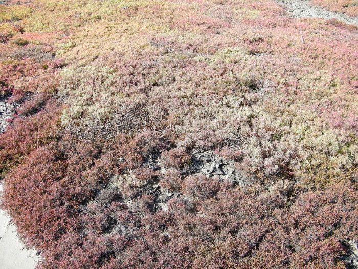
Succulent with herbShort descriptionSaltpan communities dominated by succulent and herbaceous plants. Disclaimer: Ecosystem type descriptions are based on biophysical attributes identified in Central Queensland through expert advice and supported by scientific literature. Not all ecosystem types are mapped based on current inventory, and many of the ecosystems described here may also occur in other parts of Queensland.
Classification categoriesSelect from the links below to view related ecosystem type categories Long descriptionSaltpan communities with succulent and herbaceous plants (i.e. saltmarshes) including Suaeda australis, Sarcocornia quinqueflora subsp. quinqueflora, Suaeda arbusculoides, Sesuvium portulacastrum, Tecticornia spp. (e.g. Tecticornia indica subsp. julacea, Tecticornia indica subsp. leiostachya, Tecticornia australasica) and Salsola australis. These ecosystems may be associated with salt crusts, benthic microalgal (BMA) crusts, Sporobolus virginicus, sedges and sparse stunted mangroves such as Avicennia marina, Ceriops tagal and Aegialitis annulata. Occurs on supratidal flats with deep saline clay soils and is formed from Quaternary estuarine sediments. Occurs along the landward edge of the intertidal zone in a hypersaline environment that is only inundated by the highest spring tides. The maximum height of vegetation is usually only 10 to 30 centimetres.[9] Special valuesImportant fisheries habitat providing for feeding, growth and reproduction[1]. Vegetated and non-vegetated saltpan ecosystems are used by a high number and diversity of fishes, many of economic importance, particularly in association with intertidal mangrove-lined creeks.[10] Can provide habitat for the water mouse (Xeromys myoides). This species has been recorded from coastal saltmarsh ecosystems, including succulent shrublands, saline sedgelands and grasslands, mangroves and freshwater wetlands. Water mice are known to hunt amongst mangrove pneumatophores and in shallow pools, for grapsid crabs and other intertidal crustaceans, pulmonate snails and marine gastropods. These species are common in succulent and herbaceous saltmarsh ecosystems[11][3]. Potential feeding areas and roosting areas for shorebirds provided by the habitat include a complex of bare areas adjacent to mangroves. Different species feed and roost in different habitat units of the complex. Many shorebirds and their ecosystems are listed under the Environment Protect and Biodiversity Conservation Act 1999 (EPBC). Fiddler (e.g. Uca signata) and marsh crabs (scientific name) feed in these ecosystems following inundated by rainfall or tide, and shelter in burrows at other times. Vegetated saltpan areas are generally inundated by the tide less frequently than mangroves, and these systems are under threat from sea level rise along seaward margins.[9] Diagnostic AttributesInundation 'Intertidal – Lower low', 'Intertidal – Upper low', 'Intertidal – Low undifferentiated', 'Intertidal – Lower medium', 'Intertidal – Upper-medium', 'Intertidal – Medium undifferentiated', 'Intertidal – High', 'Intertidal – Undifferentiated', 'Intertidal – High undifferentiated' (although they occur closer to the higher tidal planes which remain unmapped) Structural macrobiota – Succulent QualifiersThe Naturalness qualifier is relevant as tidal Inundation may sometimes be modified by barriers, and excavated channels, modifying inundation and terrain morphology. Changes in tidal inundation will be reflected by changes in structural macrobiota. These ecosystems fluctuate in extent over time and relevant qualifiers are Period and Trend. Changing tidal inundation due to sea level rise is causing mangroves to colonise the saltmarsh ecosystems (1, 2, 4)[6]. Invasion of mangrove into saltmarsh due to sea level rise. Breaking the BMA mat or crust (e.g. motorbikes and 4WDs) can damage the ecology of the area and bring about erosion, and it may take a long time to restore. DistributionSaltmarshes occur discontinuously along the entire coastline of Queensland and represent more than a third of the total saltmarsh area in Australia. More than 32 saltmarsh species have been described in Queensland. Saltmarsh ecosystems are often narrower where rainfall is high or spread throughout the year, and broader in extent where rainfall is relatively low or where there is a severe dry season. Plant species diversity generally increases with increasing latitude (i.e. saltmarshes are more diverse in temperate systems than tropical systems) as opposed to mangroves, which are more diverse in tropical systems[8][4][7]. The upper (landward) limits of succulent ecosystems may not be easily delineated because communities may merge into, or form, complex patterns with more freshwater grass and/or sedge communities. This transitional zone (ecotone) is not necessarily static and more freshwater plants can invade succulents during wetter periods and the more salt-tolerant succulents may advance landward during drier times.[8] Succulent ecosystems are able to tolerate high salinity, and temporary inundation from tides or, less often, from freshwater. This highly-specialised salt-tolerant vegetation has adapted to this harsh environment however it could become a weakness if tidal regimes shift (i.e. climate change), particularly in conjunction with coastal development and mangrove encroachment. That is, these succulent ecosystems could become squeezed out of the coastal zone[7]. Some of the largest saltmarshes in Queensland include:
The following relates to distribution of this ecosystem type within the Central Queensland mapping area:
CommentsOther relevant attributes include Consolidation, Energy and Sediment texture as saltmarshes typically grow on unconsolidated muds and fine sediments in low energy environments. Additional Information
References
Last updated: 11 July 2019 This page should be cited as: Department of Environment, Science and Innovation, Queensland (2019) Succulent with herb, WetlandInfo website, accessed 25 June 2024. Available at: https://wetlandinfo.des.qld.gov.au/wetlands/ecology/aquatic-ecosystems-natural/estuarine-marine/descriptions/3/ |
Site footer

 — Department of Environment, Science and Innovation