

|
|
Get mapping helpMapping at an appropriate scale and detail is necessary for natural resource management and decision making. Just as important as undertaking and producing the mapping, is the ability to access it. Wetland and groundwater dependent ecosystem (GDE) mapping is provided in a variety of formats for different user needs.
Quick facts
WetlandSummary—facts and mapsWetlandSummary is the main entry point to mapping data. Click the image below to watch a video demonstrating how to use the WetlandSummary tool. 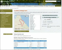 In addition to the above features, the stacked line plots produced by the Digital Earth Australia (DEA) Wetlands Insight Tool (WIT) are available in WetlandSummary, with a stacked line plot chart for every area of interest provided (such as Local Government Area, or Drainage Basin). The stacked line plot charts display the amount of open water, wet, green vegetation, dry vegetation and bare soil over time within each wetland. For WetlandSummary, the stacked line plot charts visually represent all the wetland areas in the area of interest, instead of one wetland, which is accessed via WetlandMaps. WetlandSummary also contains features such as:
WetlandMapsWetlandMaps is an interactive online map server through which users can easily access wetland information via a web-based Geographic Information System (GIS) tool. WetlandMaps is available directly or specific areas can be access directly via the WetlandSummary tool. Queensland GlobeQueensland Globe enables users to access maps, data and imagery of Queensland, including Queensland Government-owned data and data used under licence from other parties. Data downloadWetland mapping and classification mapping (wetland mapping)The wetland mapping and classification data is available via Queensland Spatial Catalogue - QSpatial and Queensland Government Data (Open data) A list of the available datasets and what they contain is available on the wetland mapping background page and via the FAQ page. Groundwater dependent ecosystem mapping (GDE mapping)The GDE mapping data is available via Queensland Spatial Catalogue - QSpatial and Queensland Government Data (Open data) A list of the available datasets and what they contain is available on the GDE mapping background page and via the FAQ page. Data from all other datasets used on WetlandSummary or WetlandMapsMetadata from all datasets is available. Many of the datasets are also available for download via Queensland Spatial Catalogue - QSpatial and Queensland Government Data (Open data). KMLsVarious KMLs are available through the WetlandSummary tool. Google Earth or similar software can be used to view KML maps. When installed, clicking on a KML button on the WetlandSummary tool should automatically open the map and zoom to the area of interest. ArcGIS, Merkaartor, Global Mapper and Marble can open KML files as well. You can open KML files with any text editor too. You can use any text editor, like Notepad in Windows. Doing this will only let you see the text version, which includes coordinates and possibly image references, camera tilt angles, timestamps, etc. Additional informationPrinting mapsMaps can be printed using WetlandMaps Wetland mapping and groundwater dependent ecosystem (GDE) mappingThe wetland mapping and GDE mapping data is available for download in Keyhole Markup Language (KML) format through the WetlandSummary tool by selecting the '100K map tiles' area type, opening the area of interest, and clicking the 'Download wetlands KML' or 'Download GDE KML' button. You can view KML files by downloading and installing Google Earth, Global Mapper, ArcGIS Explorer Desktop, or another similar program. If you have installed Google Earth it should open automatically when the KML download button is clicked. Some of the wetland and GDE mapping KMLs may be too complex to view using online KML viewers. Click the image below to watch a video demonstrating how to explore wetland KML files with Google Earth. 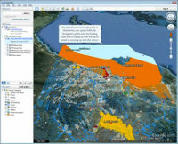 Exploring wetland KML files with Google Earth Duration 5:02 (select quality 1080p HD for the sharpest image) 'Area types' used on WetlandSummaryArea boundaries can be viewed and downloaded in KML format through the WetlandSummary tool by selecting any area type, opening the area of interest, and clicking on the 'View area boundary in Google Maps' button. You can then download the KML by clicking the 'Download this feature as KML' link on the left of the Google Maps screen. You can view KML files by downloading and installing Google Earth, Global Mapper, ArcGIS Explorer Desktop, or another similar program. If you have installed Google Earth it should open automatically when the KML download button is clicked. Environmental reports onlineOnline environmental reports provide information on specific values, by location. Reports on matters of state environmental significance, regional ecosystems and terrestrial biodiversity and aquatic conservation values are available. Queensland Wetlands ModellingThe wetland modelling page includes information on what modelling is, types of modelling, modelling of processes and species, outputs of modelling and how modelling is used for wetland management. There is also information specifically for hydrological modelling for nitrogen removal by wetlands and the pages include three conceptual models to assist with understanding how wetlands are considered at a broader catchment, contributing catchment and site scale. The Queensland Water Modelling Network (QWMN) provides the tools, information and collaborative platforms to support best-practice use of water models in Queensland. QWMN also has a publications page which includes a strategic review of models suite with documents on an assessment framework and model classification. Wetland on-line education modules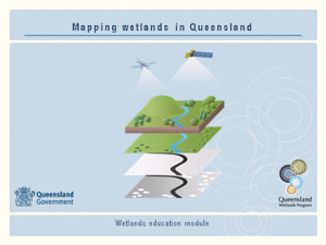 A series of on-line education modules, including Mapping wetlands in Queensland, has been prepared as a resource for people who want to learn more about wetlands. Users can download and use the contents of this education module to meet their learning and training needs. This information should be used in conjunction with information found on this website. This resource outlines the key principles of wetland mapping and should not be used for statutory purpose. Wetland SpotterWetland Spotter is a mobile application that allows the user to submit photographs and other information on wetlands across Queensland, Australia to the Queensland Herbarium for identification and mapping. Wetland Spotter allows for the quick capture key information at a wetland site through capturing photographs of the wetland margin, emergent vegetation, aquatic plants, and more. The mobile app can also be accessed via Google Play: Wetland Spotter - Apps on Google Play and iOS: Wetland Spotter on the App Store (apple.com) Pages under this sectionThis page should be cited as: Department of Environment, Science and Innovation, Queensland (2021) Get mapping help, WetlandInfo website, accessed 8 May 2025. Available at: https://wetlandinfo.des.qld.gov.au/wetlands/facts-maps/get-mapping-help/ |
Site footer

 — Department of the Environment, Tourism, Science and Innovation