

|
|
Undifferentiated coral on consolidated substrate in shallow to deep waterShort descriptionSubtidal undifferentiated coral ecosystems on consolidated substrate in shallow to deep water. Disclaimer: Ecosystem type descriptions are based on biophysical attributes identified in Central Queensland through expert advice and supported by scientific literature. Not all ecosystem types are mapped based on current inventory, and many of the ecosystems described here may also occur in other parts of Queensland.
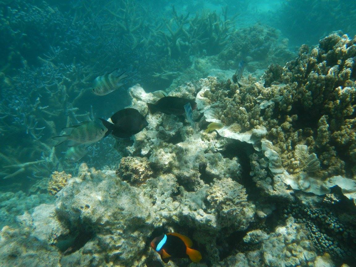
Classification categoriesSelect from the links below to view related ecosystem type categories Long descriptionSubtidal coral including hard corals, Alcyonarian soft corals and other octocorallians* on consolidated substrate (e.g. fringing reefs, shelf reefs and as coral communities on rock) in shallow (0 to 10 metres) to deep water (to 30 metres). There are distinct ecological differences between coral ecosystems growing on rock, fringing reefs and shelf reefs. The majority of fringing reefs of the coastal Great Barrier Reef began their growth on unconsolidated sediments and few originated on rock[8]. For further discussion on the different types of fringing reef, see consolidated/intermediate calcareous reef including coral platform (type 100). Typically coral fringing reefs and shelf reefs include mixtures of hard and soft corals and macroalgae and these can grow in distinct zones horizontally across a reef and vertically in depth, alternating with unconsolidated sediments and consolidated rock. Live hard corals are generally found deeper than soft corals and macroalgae. Any shallow to deep communities include soft coral (Alcyonids), but if high currents other octocorallians. For further detail on soft coral on consolidated substrates see type 99. *Octocorallia is a subclass of the class Anthozoa in the phylum Cnidaria, and include soft corals, gorgonians, sea whips, sea pens, sea fans and octocorals. Like some of the many other anthozoans, octocorallians are sessile polyp-bearing animals with a mobile larval phase. Octocorallians are distinguished by the eight (i.e. octo) tentacles in each polyp. Most octocorallians do not deposit a rigid calcium carbonate exoskeleton, and therefore tend to attach to reefs rather than contribute to reefal frameworks as per the reef building Scleractinian (hard) corals[1]. Special valuesThe values of Queensland’s coral reefs are internationally recognised in the World Heritage and Ramsar conventions. The Outstanding Universal Value of the Great Barrier Reef World Heritage area is based on four criteria (vii), (viii), (ix), (x). The Ramsar convention also includes coral reefs as one of its wetland types which make up part of a site’s ecological character (a combination of the ecosystem components, processes and services of the wetland). The Great Sandy Strait Ramsar wetland also includes coral reefs (e.g. Woody and Round Island reefs, coral communities at Little Woody Island, and soft corals on coffee rock reefs). Shoalwater and Corio Bays Ramsar wetland and the Moreton Bay Ramsar wetland also includes fringing coral reefs. Coral reefs and communities are highly valued for their diverse flora and fauna, fish habitat values, as commercial fisheries (e.g. coral trout and redthroat emperor), and are a valuable tourism resource. Coral reefs and communities also stabilise the shoreline preventing erosion and protect the coastline by moderating the impacts of waves[7]. Diagnostic attributesInundation 'Subtidal' Benthic depth 'Shallow (0-10m)', 'Deep (10-30m)'' Consolidation 'Consolidated' Structural macrobiota 'Hard/soft coral – undifferentiated' QualifiersThe Cover qualifier is relevant, especially with regard to live coral cover and macroalgal cover, for condition monitoring of coral reefs (see Additional Information). Understanding the extent and context of coral within a reef seascape is important when sampling the percentage cover of live coral, as it is possible to randomly sample a different dominant ecosystem such as macroalgae or a non-living ecosystem, skewing percent cover statistics. Report cards track condition changes in hard coral, soft corals and macroalgae but cannot be used for mapping of coral extent, unless they capture georeferenced photo transects that can be made available for other studies (e.g. remote sensing). However, mapping coral cover through remote sensing and field validation can provide accurate spatial estimates of live coral[10][9][5]. DistributionCoral reefs and communities are widespread along the east coast of Queensland and on the continental shelf from Torres Strait south to Moreton Bay[6]. They are also found in the southern Gulf of Carpentaria[2]. Live coral itself only makes up a small proportion of coral reefs, and the remainder may be macroalgae and unconsolidated ecosystems (e.g. gravels of coral rubble, sand etc.). The extent of live coral ecosystems can be measured using a combination of field validation and remote sensing, and ecosystems can be mapped at the habitat scale in the clear waters of shelf reefs through field validated coral reef remote sensing studies and incorporating decision rules based on biophysical attributes (e.g. Benthic depth, Slope and Energy magnitude[1][6][10]). On shelf edge reefs it is easier to determine live coral composition than on fringing reefs due to Water clarity, thus coral ecosystems on fringing and inshore reefs are under-mapped (although they are the focus of many monitoring programs - see Additional Information). CommentsSubstrate composition is relevant as corals growing on carbonate substrates demonstrate continuous reefal growth over the past 6,000 years. The scale or level is relevant, as a Consolidated substrate at a broad seascape scale may at the habitat scale be made up of small areas of consolidation and large areas of unconsolidated sediment. Benthic rugosity of coral reefs is important for creating three-dimensional living space for biota including fish, and allowing more shading which can protect corals during bleaching events[4]. Water temperature is critical to all corals as they are sensitive to extremes of heat and cold, resulting in bleaching due to the loss of endosymbiotic dinoflagellates (e.g. zooxanthellae) and therefore the ability to photosynthesise[3]. Additional InformationProtecting the Great Barrier Reef - Queensland Government Coral - Department of Environment, Science and Innovation Coral reefs - Queensland Museum The Reef - Great Barrier Reef Marine Park Authority Nationally (DIWA) and internationally important (Ramsar) wetlands - WetlandInfo Coral Indicators for the 2017 Gladstone Harbour Report Card - Australian Institute of Marine Science Reef Report Card 2016 - Queensland Government Great Barrier Reef Outlook Report - Great Barrier Reef Marine Park Authority Monitoring inshore reefs - Australian Institute of Marine Science Reef Check Methods - Reef Check Australia Coral reefs - Museum of Tropical Queensland Remote Sensing Research Centre - The University of Queensland References
Last updated: 11 July 2019 This page should be cited as: Department of Environment, Science and Innovation, Queensland (2019) Undifferentiated coral on consolidated substrate in shallow to deep water, WetlandInfo website, accessed 30 August 2024. Available at: https://wetlandinfo.des.qld.gov.au/wetlands/ecology/aquatic-ecosystems-natural/estuarine-marine/descriptions/90/ |
Site footer

 — Department of Environment, Science and Innovation