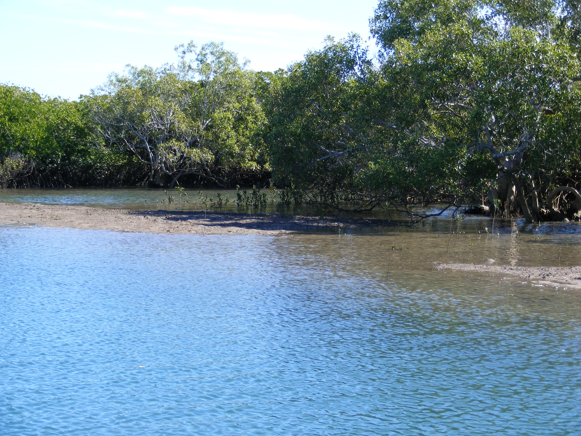
Skip links and keyboard navigation

Avicennia-dominated mangroves

Short description

Mangrove forest dominated by Avicennia marina.

Disclaimer: Ecosystem type descriptions are based on biophysical attributes identified in Central Queensland through expert advice and supported by scientific literature. Not all ecosystem types are mapped based on current inventory, and many of the ecosystems described here may also occur in other parts of Queensland.

Avicennia-dominated mangrove forest. Photo by Natalie Kastner, Queensland Government

Classification categories

Select from the links below to view related ecosystem type categories

Long description

Mangrove forest dominated by Avicennia marina subsp. australasica, typically along the seaward margin of mangrove forests. Occurs on Quaternary estuarine deposits, on intertidal flats which are often dissected by tidal streams. Soils are often deep saline clays[10]. Avicennia marina typically dominates pioneering mangrove communities with more unstable sediments, whereas Rhizophora spp. typically dominate areas with more stable sediments[10].

Mangroves are not a taxonomically unified group, but rather an ecological group that arose through convergent evolution and includes several different families. They are characterised by trees that are adapted to tolerate tidal inundation.

Special values

Mangrove communities provide a wide variety of services, including:

  • physical coastal protection from erosion and flooding
  • sediment trapping
  • primary production
  • nutrient uptake
  • food source (Avicennia seeds) for Green sea turtles (Chelonia mydas)[11]
  • food, shelter and breeding areas for a wide range of fauna including birds, water mouse (Xeromys myoides) (landward margin), fish, crustaceans and other invertebrates[7][2][12][4]
  • prey for fish, which tend to use the edge of the mangroves when foraging[13].

Avicennia pneumatophores provide structural habitat for a range of fish, crustaceans and molluscs (including oysters and barnacles). The water mouse has also been observed hunting in pneumatophores, and nesting in the landward margin of mangrove forests. Dense growth of the red algae Catenella nipae on mangrove pneumatophores provides food for recreationally important herbivorous fishes[3].

Diagnostic attributes

Inundation 'Intertidal – Lower low', 'Intertidal – Mid low', 'Intertidal – Upper low', 'Intertidal – Low undifferentiated', 'Intertidal – Lower medium', 'Intertidal – Upper-medium', 'Intertidal – Medium undifferentiated', 'Intertidal – High', 'Intertidal – Undifferentiated', 'Intertidal – High undifferentiated', although mangroves usually occur at mean sea level and above.

Structural macrobiota 'Mangroves – Avicennia'

Qualifiers

No qualifiers mapped, however Period and Trend are relevant as Rhizophora forests typically extend from the seaward boundary and can be influenced by sea level rise.

Relevant attributes associated with change (e.g. mangrove dieback) in Moreton Bay include Freshwater source, Freshwater volume and Trace elements/nutrients.

Relevant attributes associated with change for Gulf of Carpentaria include Inundation (sea level changes associated with extreme weather events)[5][8].

Distribution

The north-east coast of Australia was close to the centre of mangrove origin and dispersal. The climate is similar to that under which they first evolved, and the sheltered shallow waters of numerous estuaries are ideal for growth[9][6]. Avicennia marina is the most common and widespread mangrove along the mainland coast of Australia, extending from Corner Inlet in Victoria to Bunbury in Western Australia[7].

The following relates to distribution of this ecosystem type within the Central Queensland mapping area:

  • Avicennia marina or Ceriops spp. typically dominate higher energy areas from Tin Can Inlet to Round Hill Head, with mixed communities landward. In low energy waters from Tin Can Inlet to Round Hill Head, there are typically closed Avicennia/Ceriops forests landward of closed Rhizophora forests[1]. Avicennia marina tends to dominate mangrove forests south of Fraser Island[2].
  • Particularly important fisheries habitat from Round Hill Head to Tin Can Inlet, in terms of productivity, includes the Kolan, Elliott, Burrum, Mary and Susan rivers, Baffle and Kauri creeks, Great Sandy Strait and Tin Can Inlet. The smaller Broadwater, Littabella and Beelbi creeks are also important in terms of habitat diversity and connectivity with the larger nearby systems (Baffle Creek, and the Kolan and Burrum rivers)[1].

Comments

Other relevant attributes include Consolidation, Energy and Sediment texture as mangrove communities typically occur on unconsolidated muds and fine sediments in low energy environments.

Additional Information

Moreton Bay mangroves and associated communities interactive map viewer - WetlandInfo

Mangroves - WetlandInfo

Mangroves - Queensland Government

Common mangroves - Department of Agriculture and Fisheries

MangroveWatch

Mangrove Challenge

Mangrove community dynamics - OzCoasts

Mangroves and associated communities of Moreton Bay - WetlandInfo

Serious Dieback of Mangroves around Mackay - University of Queensland


References

  1. ^ a b Bruinsma, C & Danaher, K (2001), Queensland Coastal Wetland Resources: Round Hill Head to Tin Can Inlet.. [online], vol. QI99081, Department of Primary Industries, Queensland Government., Brisbane. Available at: http://era.daf.qld.gov.au/id/eprint/3545/.
  2. ^ a b Danaher, K, Rasheed, M & Thomas, R (2005), The intertidal wetlands of Port Curtis, Department of Primary Industries and Fisheries.
  3. ^ Davis, AM, Lewis, SE, Brodie, JE & Benson, A (2014), 'The potential benefits of herbicide regulation: A cautionary note for the Great Barrier Reef catchment area', Science of the Total Environment. [online], vol. 490, pp. 81-92. Available at: Scopus.
  4. ^ Duke, N (2006), Australia’s Mangroves: the authoritative guide to Australia’s mangrove plants, University of Queensland, Brisbane.
  5. ^ Duke, N & Oosterzee, P (2017), Extreme weather likely behind worst recorded mangrove dieback in northern Australia. [online] Available at: https://www.researchgate.net/profile/Norman_Duke/publication/316877283_Extreme_weather_likely_behind_worst_recorded_mangrove_dieback_in_northern_Australia/links/591562300f7e9b70f49c5521/Extreme-weather-likely-behind-worst-recorded-mangrove-dieback-in-northern-Australia.pdf.
  6. ^ Great Barrier Reef Marine Park Authority (GBRMPA) (2007), Great Barrier Reef (GBR) Features (Reef boundaries, QLD Mainland, Islands, Cays, Rocks and Dry Reefs) (GBRMPA) (metadata), eAtlas Data Catalogue AIMS, Townsville.
  7. ^ a b Lovelock, C (1993), Field guide to the mangroves of Queensland, AIMS.
  8. ^ Lovelock, CE, Feller, IC, Reef, R, Hickey, S & Ball, MC (December 2017), 'Mangrove dieback during fluctuating sea levels', Scientific Reports. [online], vol. 7, no. 1, p. 1680. Available at: http://www.nature.com/articles/s41598-017-01927-6 [Accessed 30 May 2019].
  9. ^ Queensland Government (2019), Mangroves - WetlandInfo. [online] Available at: https://wetlandinfo.des.qld.gov.au/wetlands/ecology/components/flora/mangroves/.
  10. ^ a b Queensland Herbarium & Environmental Protection Agency, B (2005), Regional Ecosystem Description Database (REDD). Version 5.0. [online], Environmental Protection Agency, Brisbane. Available at: https://apps.des.qld.gov.au/regional-ecosystems/.
  11. ^ Read, A & Limpus, C (2002), 'THE GREEN TURTLE, CHELONIA MYDAS, IN QUEENSLAND: FEEDING ECOLOGY OF IMMATURE TURTLES IN MORETON BAY, SOUTHEASTERN QUEENSLAND', Memoirs of the Queensland Museum, Brisbane.
  12. ^ Sheaves, M (2005), 'Nature and consequences of biological connectivity in mangrove systems', Marine Ecology Progress Series. [online], vol. 302, pp. 293-305. Available at: http://www.int-res.com/abstracts/meps/v302/p293-305/ [Accessed 15 March 2019].
  13. ^ Sheaves, M, Johnston, R & Baker, R (10 May 2016), 'Use of mangroves by fish: new insights from in‑forest videos', Marine Ecology Progress Series. [online], vol. 549, pp. 167-182. Available at: http://www.int-res.com/abstracts/meps/v549/p167-182/ [Accessed 31 May 2019].

Last updated: 12 July 2019

This page should be cited as:

Department of Environment, Science and Innovation, Queensland (2019) Avicennia-dominated mangroves, WetlandInfo website, accessed 18 March 2024. Available at: https://wetlandinfo.des.qld.gov.au/wetlands/ecology/aquatic-ecosystems-natural/estuarine-marine/descriptions/8/

Queensland Government
WetlandInfo   —   Department of Environment, Science and Innovation