

|
|
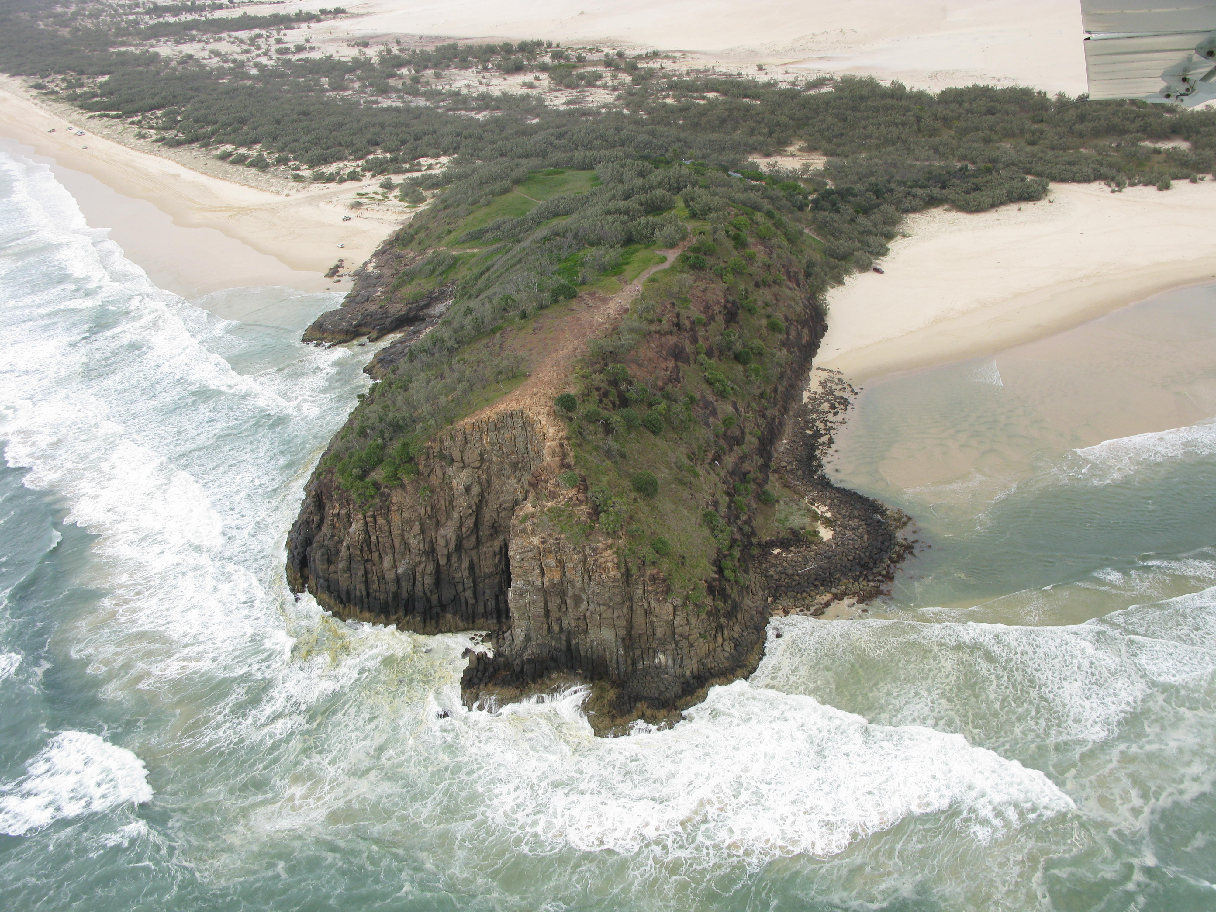
Intertidal high energy over consolidated substrateShort descriptionIntertidal high wave energy rocky headlands and wave-cut platforms. Disclaimer: Ecosystem type descriptions are based on biophysical attributes identified in Central Queensland through expert advice and supported by scientific literature. Not all ecosystem types are mapped based on current inventory, and many of the ecosystems described here may also occur in other parts of Queensland.
Classification categoriesSelect from the links below to view related ecosystem type categories Long descriptionIntertidal very high to medium wave energy rocky headlands and wave-cut platforms with geology of mineral rock or chemical origin (terrigenous) where biota extent is unsurveyed. The Lithology or rock type may influence the shape, chemistry and nature of the biota growing on these ecosystems. Potentially the rocky reef ecosystems have a suite of algae, and other encrusting fauna such as octocorallians*. NB this ecosystem type includes modified ecosystems including those composed of concrete and other man-made materials such as boat ramps, jetties and port infrastructure. Very high and high oceanic wave energy on these shorelines creates a splash zone (the supralittoral zone) above the usual tidal limits with a characteristic biota of barnacles and periwinkles. Tidal inundation also creates strong faunal zonation from highest to lowest tidal extremes (e.g. periwinkle, barnacles, tubeworms and finally ascidians and/or macroalgae). There is also energy-based zonation along the shore with a typically windward environment (high energy with south-easterly aspect) and typically leeward environment (lower energy with northerly aspect), with different species composition in each area (i.e. microhabitats)[1]. Intertidal rocky shore biota are subject to desiccation, being alternately exposed to the air and submerged. Many animals have adaptations that allow them to survive in air or retain water, such as the strong foot of limpets sealing moisture against the rock, the plates of barnacles that close, the tight valves sealing oysters and mussels, and the operculum (trapdoor) of periwinkles. Wave action and mechanical action from pebbles wears holes in weaker parts of the rock, creating pools and crevices above the low tide mark that provide moist habitat for animals normally intolerant to desiccation, and extending their vertical range higher up the rocky shoreline[1]. Rocky shore molluscs (e.g. periwinkles and nerites) migrate up and down according to the tide level, following the tide down as it falls. Corals are not usually associated with intertidal high energy rocky shores[3][5]. *Octocorallia is a subclass of the class Anthozoa in the phylum Cnidaria, and include soft corals, gorgonians, sea whips, sea pens, sea fans and octocorals. Like some of the many other anthozoans, octocorallians are sessile polyp-bearing animals with a mobile larval phase. Octocorallians are distinguished by the eight (i.e. octo) tentacles in each polyp. Most octocorallians do not deposit a rigid calcium carbonate exoskeleton, and therefore tend to attach to reefs rather than contribute to reefal frameworks as per the reef building Scleractinian (hard) corals[4]. Special valuesTidal pools form above the water mark and provide submerged habitat for typically subtidal species[1]. Rocky shores provide habitat for a wide range of sessile flora and fauna. Shorebird feeding habitat for resident species such as the beach stone curlew and sooty oyster catcher[2]. Diagnostic attributesInundation 'Intertidal – Lower low', 'Intertidal – Mid low', 'Intertidal – Upper low', 'Intertidal – Low undifferentiated', 'Intertidal – Lower medium', 'Intertidal – Upper-medium', 'Intertidal – Medium undifferentiated', 'Intertidal – High', 'Intertidal – Undifferentiated', 'Intertidal – High undifferentiated' Consolidation 'Consolidated' Energy magnitude (wave) 'Very High', 'High', 'Medium' QualifiersCan also include modified ecosystem types such as intertidal parts of boat ramps, jetties and port infrastructure. The biota growing on these ecosystems would be very different from that growing on natural rocky or coffee rock ecosystems. DistributionThe northern-most limit of very high energy rocky shorelines along the Queensland coast (Australian east coast) is Double Island Point/K'gari (Fraser Island). K'gari (Fraser Island) and the Great Barrier Reef form a barrier to wave energy. Double Island Point/K'gari (Fraser Island) is a major boundary between subtropical and temperate species compositions (e.g. of molluscs and barnacles). Further south near Moreton Bay more characteristic temperate species appear, including a pronounced tubeworm structural zone (Galaeolaria spp.), starfish Patiriella spp. and the anemone Heliocidaris spp.[5][3]. The following relates to distribution of this ecosystem type within the Central Queensland mapping area:
CommentsRelevant additional attributes include Substrate composition, Energy source and Energy magnitude, Lithology. The Terrain slope, Terrain roughness and Terrain morphology are indicative of the presence of cliffs, platforms, terraces, pools and crevices for potential shelter of biota. For example, the microhabitats of gently sloping surfaces experience different wave energy with a different biota composition than that of steeply sloping and near-vertical surfaces[3]. Additional InformationCoastal Marine Habitats - Rocky Shore Queensland Museum - Intertidal Rocky Shores Museum of Tropical Queensland - Intertidal Rocky Shores References
Last updated: 12 July 2019 This page should be cited as: Department of Environment, Science and Innovation, Queensland (2019) Intertidal high energy over consolidated substrate, WetlandInfo website, accessed 8 May 2025. Available at: https://wetlandinfo.des.qld.gov.au/wetlands/ecology/aquatic-ecosystems-natural/estuarine-marine/descriptions/23/ |
Site footer

 — Department of the Environment, Tourism, Science and Innovation