The Galilee Basin is a geological basin comprising a series of sedimentary formations deposited during the Permian and Triassic periods. The oldest sediments are of early Permian age and are overlain by the Colinlea Sandstone and the Bandanna Formation. Overlying the Permian deposits are the Triassic sediments, the Rewan Formation and Dundas Beds. The Dundas Beds are generally classified as consisting of coarse-grained sediments and therefore a water-bearing aquifer. The Rewan Formation generally consists of fine-grained material and is therefore generally considered as a confining aquitard. However, both these strata are non-uniform and include both coarse and fine-grained facies. The sediments dip east to west at an angle of about 1-2 degrees, although this dip angle seems to steepen slightly in the north near the Carmichael River.
On the eastern edge of the Galilee Basin, the Colinlea Sandstone approaches the surface but in many areas is overlain by Tertiary sediments and Quaternary deposits. In the south-eastern corner of the Galilee Basin, the Colinlea Sandstone has extensive outcrop on the foothills of the Carnarvon Ranges.
Additional information
Section 5 of the DSITI 2015, Lake Eyre Basin Springs Assessment Final Report, Queensland Government, Brisbane.
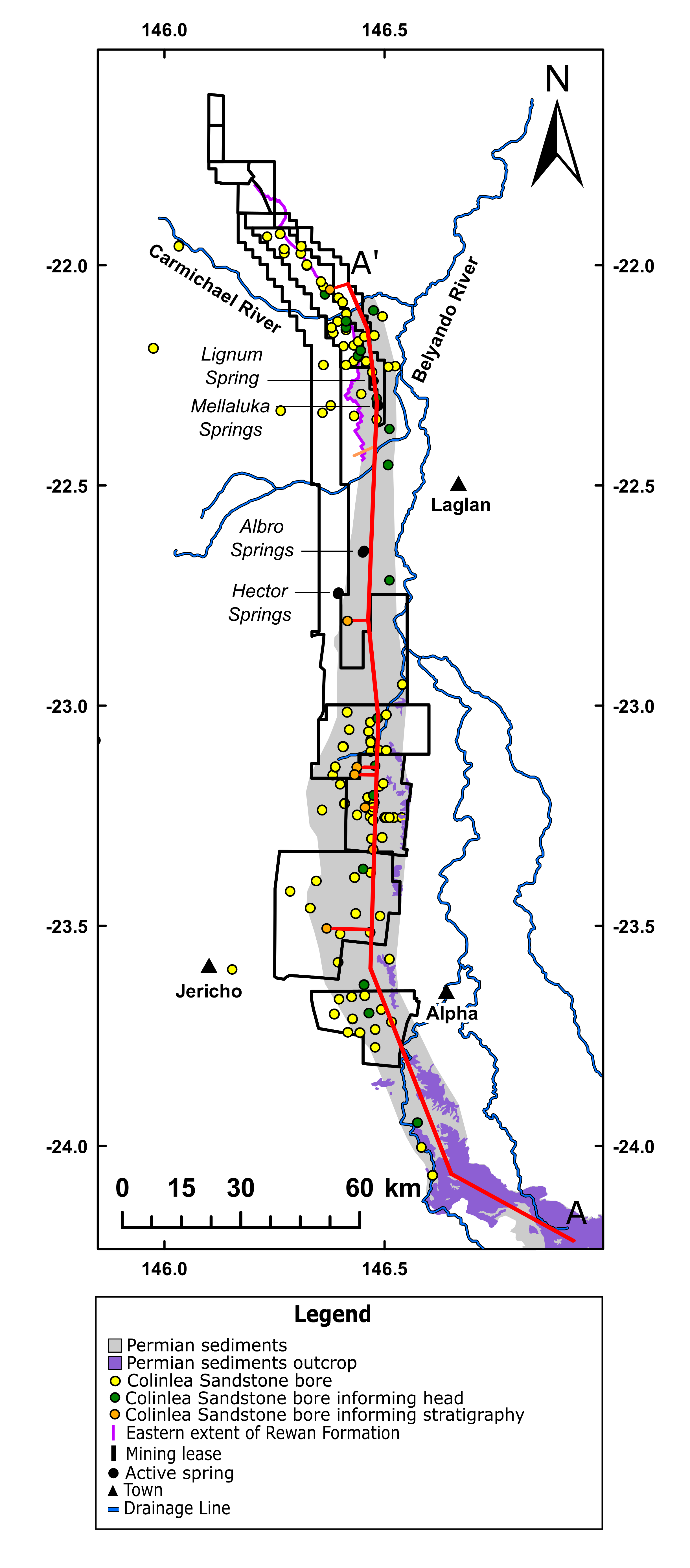
There are springs forming a south-north line to the west of the Belyando River. These springs appear to overlie the basement strata of the Colinlea sandstone in the vicinity of the E and F coal seams. Off-set from this line to the south-west is Hector Springs. Due to its position and the inferred hydraulic head in the Colinlea Sandstone, Hector Springs has been interpreted as having its source in the Triassic units of the Galilee Basin and is considered in a separate section of this report. The springs interpreted as having a source in the Permian sediments of the Galilee Basin are Albro Springs, two vents with moderate flows (combined flow ~40 l/min) and Mellaluka Springs (three vents with combined flow ~1200 l/min) and Lignum Spring (~0.5l/min).
The potentiometric surface derived from bores in the Colinlea Sandstone strongly suggests a predominantly south-north flow from the areas of outcrop at about 570 m altitude. This gradient is parallel with the ground surface, but perpendicular to the westward dip of the sediments. There may also be a downslope gradient to the west. However, the connectivity between the deep sediments of the Galilee Basin at their western margin and the overlying basal units of the Eromanga Basin are poorly known. It is probable that throughflow along the westward dipping sediments is constrained. The south-north flow structure seems to be the dominant influence on hydraulic head and spring flows.
Additional information
Section 5 of the DSITI 2015, Lake Eyre Basin Springs Assessment Final Report, Queensland Government, Brisbane.
Last updated: 19 May 2015
This page should be cited as:
Queensland Government, Queensland (2015) Galilee Springs, WetlandInfo website, accessed 18 March 2024. Available at: https://wetlandinfo.des.qld.gov.au/wetlands/ecology/aquatic-ecosystems-natural/groundwater-dependent/supergroup-galilee/


 — Department of Environment, Science and Innovation