

|
|
Intertidal mud above mean sea level unconsolidated mud (claypan/saltpan)Short descriptionIntertidal mud above mean sea level unconsolidated mud (claypan/saltpan). Disclaimer: Ecosystem type descriptions are based on biophysical attributes identified in Central Queensland through expert advice and supported by scientific literature. Not all ecosystem types are mapped based on current inventory, and many of the ecosystems described here may also occur in other parts of Queensland.
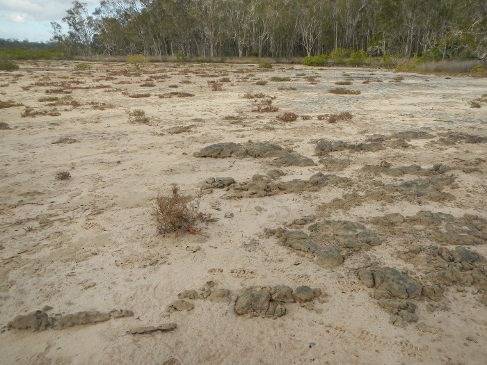
Classification categoriesSelect from the links below to view related ecosystem type categories Long descriptionIntertidal mud above mean sea level (MSL) including: mud banks, saltpans, claypans, or river banks above the mangrove line (approximately MSL). Typically these areas appear to be bare, unvegetated areas, which may or may not have a crust of benthic microalgae (BMA). May have similar biota equivalent to ecosystem type bare above MSL (type 17), which is mapped by the Herbarium. These ecosystems are typically adjacent to saltmarsh and mangrove communities, and the boundary between the bare area and the saltmarsh and mangroves can shift in association with changes in catchment runoff (rainfall, stormwater, altered flows, land use), and in the longer term sea level rise. Can include channels and pools. BMA provides food for crustaceans (e.g. crabs) and molluscs (e.g. whelks). Breaking the BMA mat or crust (e.g. motorbikes and 4WDs) can damage the ecology of the area and bring about erosion, and it may take a long time to restore. Special valuesImportant fisheries habitat that can provide for feeding, growth and reproduction[1]. Vegetated and non-vegetated saltpan-associated ecosystems are used by a high number and diversity of fishes (many of economic importance), particularly in association with intertidal mangrove-lined creeks[3]. Fiddler and marsh crabs feed in these ecosystems following inundated by rainfall or tide, and shelter in burrows at other times. Unvegetated saltpan adjacent to coastal wetlands provide feeding areas for high value fisheries species. Fish, such as sand whiting, yellow fin bream, threadfin salmon and flathead feed on benthic crustaceans, bivalve molluscs and polychaete worms that are abundant in these bare areas[2]. Can provide part of the habitat complex for the water mouse (Xeromys myoides)[6][5]. Potential feeding areas and roosting areas for shorebirds provided by the habitat complex of bare areas adjacent to mangroves. Different species feed and roost in different habitat units of the complex[4]. Many shorebirds Environment Protection and Biodiversity Conservation Act 1999-listed species (EPBC). Potentially these areas are habitat for non-filtering feeding infauna (bottom feeding detritus such as polychaete worms), and habitat for filter-feeders in highly riverine or strong current areas with slightly clearer water. Diagnostic attributesInundation 'Intertidal – Medium undifferentiated', 'Intertidal – High', 'Intertidal – Undifferentiated', 'Intertidal – High undifferentiated' Sediment texture 'MUD', 'gravelly MUD', 'muddy SAND', ''(slightly gravelly) sandy MUD', '(slightly gravelly) MUD', 'sandy MUD' (note that the dominant grain size is capitalised) Benthic depth 'Intertidal (>0m)' QualifiersCan includes the high intertidal sections of mapped modified ecosystems that have modified Benthic depth and Terrain morphology including dredged channels, bunds and infilling of the intertidal area. Although unmapped, Period and Trend qualifiers are also relevant as the Energy magnitude may also vary seasonally and episodically with respect to wave action and king tides and storm surges. DistributionCommon up and down the Queensland coast, particularly in association with river mouths along protected coastlines in protected waters such as bays and inlets. The following relates to distribution of this ecosystem type within the Central Queensland mapping area:
CommentsOther relevant attributes can include Freshwater input volume, Freshwater input source, Tidal range, Terrain relative relief, Terrain morphology, Terrain slope, Terrain pattern and Sediment composition. Additional InformationIntertidal mud flats - Queensland Museum Tidal planes - Maritime Safety Queensland References
Last updated: 22 July 2019 This page should be cited as: Department of Environment, Science and Innovation, Queensland (2019) Intertidal mud above mean sea level unconsolidated mud (claypan/saltpan), WetlandInfo website, accessed 25 June 2024. Available at: https://wetlandinfo.des.qld.gov.au/wetlands/ecology/aquatic-ecosystems-natural/estuarine-marine/descriptions/27/ |
Site footer

 — Department of Environment, Science and Innovation