|
|
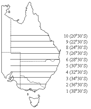
Aerial Surveys of Waterbirds in Eastern AustraliaCoverageThe map below highlights the areas where sampling has occurred for this program. Click on the map to view information about the drainage basins in this area.  Aerial Surveys of Waterbirds in Eastern Australia is a collaborative program that monitors ten survey bands that intersect Queensland, New South Wales, Victoria and South Australia. Program start date1983 Program end dateOngoing Objectives of the programThis program aims to:
Who is involved?Lead organisationContact details of lead organisation: awar.info♲unsw.edu.au Partner organisationsNew South Wales, South Australian, Queensland and Victorian State Governments List of indicators monitored
Scale of programQueensland, New South Wales, Victoria and South Australia Brief description of sampling locationsAn area of 2,697,000 km2 is systematically sampled with ten survey bands 30 km in width, spaced every 2° of latitude from 38°30’S to 20°30’S. Frequency of monitoringAnnual monitoring each October Where is the program reported?Aerial Surveys of Waterbirds in Eastern Australia Last updated: 22 March 2013 This page should be cited as: Department of Environment, Science and Innovation, Queensland (2013) Aerial Surveys of Waterbirds in Eastern Australia, WetlandInfo website, accessed 8 May 2025. Available at: https://wetlandinfo.des.qld.gov.au/wetlands/assessment/monitoring/current-and-future-monitoring/aerial-surveys-waterbirds-eastern-australia.html |

 — Department of the Environment, Tourism, Science and Innovation

