Buffers and swales are suited to small areas throughout the farm that are not used for agricultural production, such as headlands, drainage lines, access tracks (infrequent traffic) and easements. They should be located throughout the farm, immediately adjacent to the agricultural production areas such as at the end of crop rows, where they can receive dispersed, not channelized, flow from a relatively small upstream catchment. If the catchment is large, flow volume and velocity will be too large for effective water treatment and may cause channelisation and scour[5][6].
Even if buffers and swales are not used for treating run-off, they should still be included in the farm layout as an effective way to prevent erosion and provide other functions (habitat, flood mitigation etc.) between the production area and adjoining drainage lines or waterways (Figure 1).
Sizing
Buffers:
Width and slope are the two main factors determining the capacity of vegetated buffers to treat surface run-off as they influence water velocity and detention time and hence treatment[4]. The width of a buffer is the distance water travels from the production area to the waterway and the required width will depend on the purpose for the buffer. For example, it takes a longer time for soluble nutrients and pesticides to infiltrate or be adsorbed than it does for coarse sediments to settle out. Therefore a wider buffer is needed to remove nutrients and pesticides than sediments[9].
For low to moderate slopes most sediment filtering occurs in the first 10m, but wider buffers are required for steeper slopes, soils with fine particles, where there is a large contributing catchment and regions with high intensity rainfall[2]. In these instances, it may not be cost effective to have very large buffers to treat run-off, instead buffers may be better suited to preventing erosion, with other treatment systems used to remove sediments, nutrients and pesticides.
There are multiple ways to estimate the required width of a vegetated buffer for removing sediment from run-off. One approach is to use the area of the block, the annual soil loss from the block and the length of the buffer into which the sediment is deposited with equations provided in Prosser and Karssies, 2001[7]. Another alternative is to use indicative widths calculated for different regions, soil erodibility and slope in the Wetland Management Handbook.
Swales:
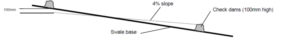
Swales should be wide enough to convey water flows at a velocity that does not cause erosion and facilitates infiltration and sedimentation (note that the width of a swale refers to the distance between the outer banks of the swale). This will depend on the size of the contributing catchment, slope, erodibility of soil, target pollutant and type and extent of vegetation[8][9]. The length of a swale is likely to be constrained by the existing production areas on a farm, but the length will influence the residence time of water within the swale. Some studies suggest a residence time of 5-6 minutes to enhance the trapping efficiency of a swale[10]. If the length is constrained, low weirs/check dams can be used to slow water and increase infiltration and sedimentation[3].
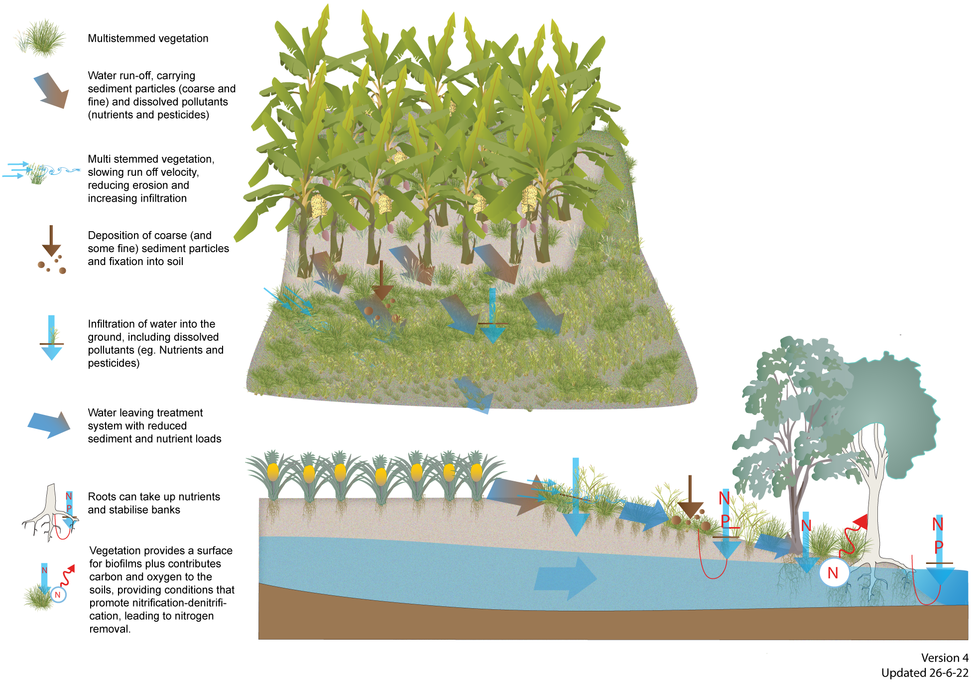
Dispersed, not channelised, flow entering buffer or swale - to ensure a uniform, low velocity flow throughout the full width of the structure, rather than in channels. Channelling significantly reduces the efficacy of buffers and swales by increasing the flow velocity[4].
Small upstream catchment - to prevent high water volumes and velocities.
Moderate slope - to be effective at removing sediment, the water flow needs to be slow enough to enable sedimentation and infiltration. On steep land water may flow through the buffer or swale too fast to enable effective water treatment and in these instances a wider buffer or longer swale may be required[4], or a series of level swales with drops or check dams between them (Figure 5). If check dams are used on steeper slopes be careful to avoid scour downstream of and around the check dam[3]. A very flat vegetated buffer or swale can get too waterlogged, causing vegetation damage if there is any vehicle traffic. A review of buffers by Liu et al[4] suggests a 9% slope maximises sediment trapping efficacy, while slopes of less than 3% is preferred for swales.
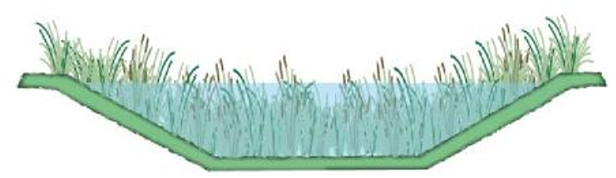
Wide and shallow swale with flat bottom (trapezoidal shape) (Figure 5) or shallow dish-shaped - to facilitate low velocities and uniform flow. The depth and batter slope of the swale will influence the conveyance capacity and overall footprint of the swale and should be designed with consideration of maintenance (mown/slashed edges should have batters flatter than 1:3 vertical:horizontal)[1]. The width, depth and batters of a swale should also be designed so that flow velocity, water depth and batter gradient do not pose a safety hazard to people on the farm. Guides for designing swales can be found in the Queensland Soil Conservation Guidelines and Water Sensitive Urban Design technical design guidelines for the coastal dry tropics.
Suitable vegetation type and height – vegetation needs to be kept dense, with at least 80% ground cover to promote uniform water flows and facilitate infiltration and sedimentation[8]. To maximise infiltration into the soil and sedimentation, avoid bare areas such as stock tracks and tussock grasses, which will cause water to concentrate in preferential flow paths and result in channelisation[7]. The height and type of vegetation will influence the treatment performance of buffers and swales and should be selected based on the pollutant to be treated and the site conditions. If the water depth is greater than the height of the vegetation, vegetation won’t effectively decrease flow velocity thereby decreasing treatment efficacy. Generally water depth should be kept below 10cm -15 cm[4][3]:
Low vegetation (such as mown grass) can achieve moderate sediment deposition rates provided flows are shallow (less than the height of the vegetation), well distributed across the buffer or swale and the grade of the buffer or swale is kept low enough to maintain slow flow velocities.
Taller, reed type vegetation can offer improved sediment retention by slowing flows more than grass and providing enhanced sedimentation for deeper flows. However, densely vegetated swales have higher hydraulic roughness (i.e. more friction) and therefore require a larger area to convey flows compared to grass swales.
Trees and shrubs can facilitate denitrification of shallow groundwater and are good at stabilising banks, but are not as effective as grass buffers or swales for treating surface run-off[5][9].
Disclaimer
In addition to the standard disclaimer located at the bottom of the page, please note the content presented is based on published knowledge of treatment systems. Many of the treatment systems described have not been trialled in different regions or land uses in Queensland. The information will be updated as new trials are conducted and monitored. If you have any additional information on treatment systems or suggestions for additional technologies please contact us using the feedback link at the bottom of this page.
^abc Ekka, SA, Rujner, H, Leonhardt, G, Blecken, GT, Viklander, M & Hunt, WF (February 2021), 'Next generation swale design for stormwater runoff treatment: A comprehensive approach', Journal of Environmental Management. [online], vol. 279, p. 111756. Available at: https://linkinghub.elsevier.com/retrieve/pii/S0301479720316819 [Accessed 12 April 2022].
^abcde Liu, X, Zhang, Z & Zhang, M (2008), 'Major factors influencing the efficacy of vegetated buffers on sediment trapping: A review and analysis', Journal of Environmental Quality, vol. 37, pp. 1667-1674.
^ab McKergow, LA, Prosser, IP, Grayson, RB & Heiner, D (2004), 'Performance of grass and rainforest riparian buffers in the wet tropics, Far North Queensland. 2. Water quality.', Australian Journal of Soil Research, vol. 42, no. 4, pp. 485-498.
^ Norris, V (1993), 'The use of buffer zones to protect water quality: a review.', Water Resources Management, vol. 7, no. 4, pp. 257-272.
^ab Prosser, I & Karssies, L (2001), Designing filter strips to trap sediment and attached nutrients - River and Riparian Land Management Technical Guideline, vol. No. 1, Land and Water Australia, Canberra.
^ab Reichenberger, S, Bach, M, Skitschak, A & Frede, H (2007), 'Mitigation strategies to reduce pesticide inputs into ground- and surface water and their effectiveness; a review.', Science of the Total Environment, vol. 384, pp. 1-35.
^ Winston, RJ, Anderson, AR & Hunt, WF (January 2017), 'Modeling Sediment Reduction in Grass Swales and Vegetated Filter Strips Using Particle Settling Theory', Journal of Environmental Engineering. [online], vol. 143, no. 1, p. 04016075. Available at: https://ascelibrary.org/doi/10.1061/%28ASCE%29EE.1943-7870.0001162 [Accessed 27 October 2022].
Last updated: 5 November 2022
This page should be cited as:
Department of Environment, Science and Innovation, Queensland (2022) Vegetated buffers and swales — Planning and design, WetlandInfo website, accessed 8 May 2025. Available at: https://wetlandinfo.des.qld.gov.au/wetlands/management/treatment-systems/for-agriculture/treatment-sys-nav-page/vegetated-buffers/planning-design.html


 — Department of the Environment, Tourism, Science and Innovation