

|
|
Sediment basinsSediment basins — Planning and design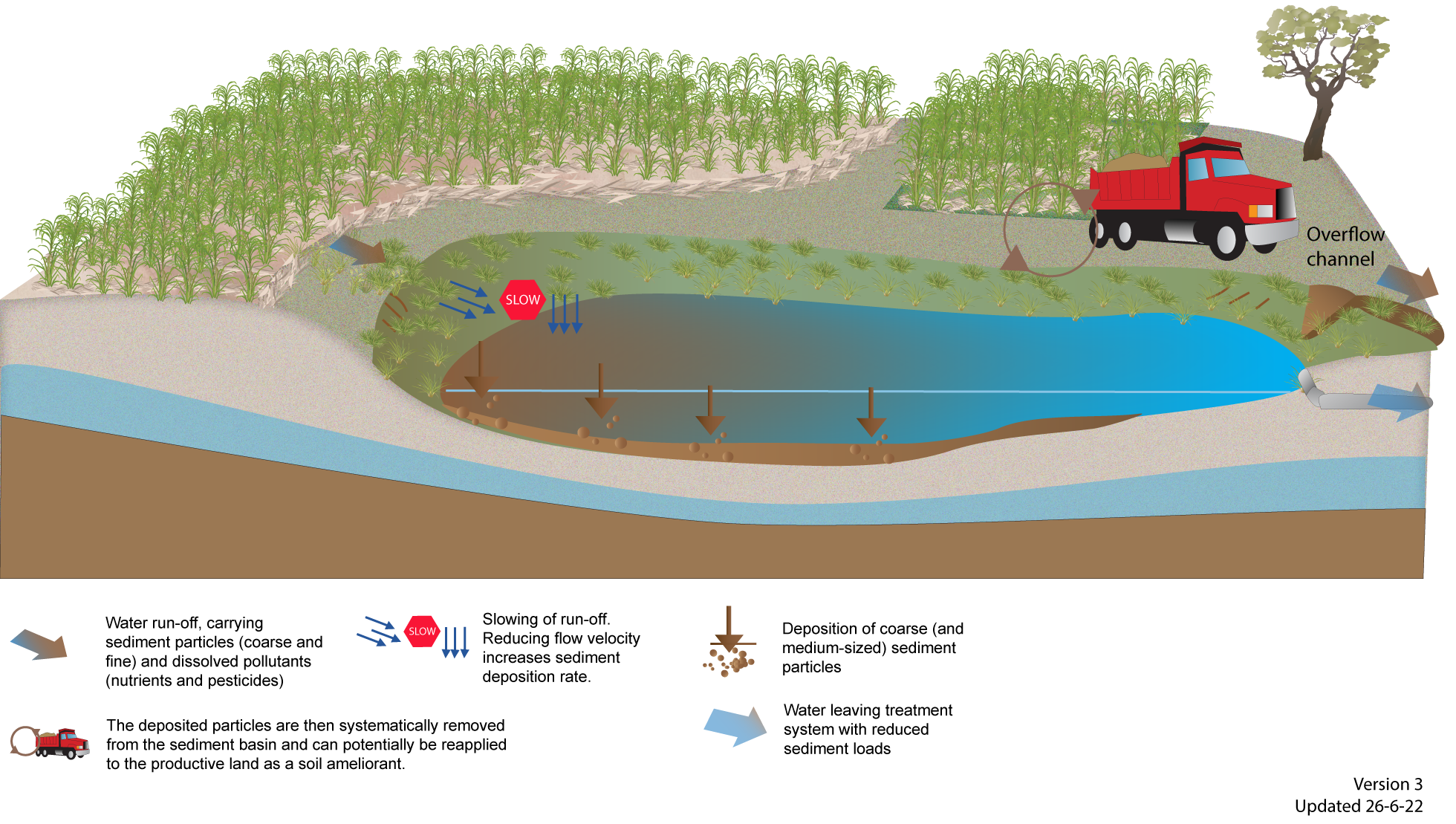 Select from the tabs below Site selectionSediment basins can be located throughout the farm. Small basins can be used within drainage lines, while larger basins should be used where water flows converge and prior to water entering other treatment systems or natural wetlands or waterways. Site assessment will determine whether it is better to use a series of smaller basins or a single, larger basin. Sediment basins are not ideally suited to sites with:
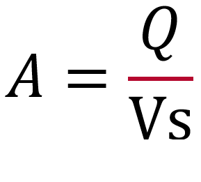
These site characteristics don’t preclude the use of sediment basins, but they may require additional design considerations and have cost implications. Flat catchments can also pose a problem when trying to convey flows to a central sediment basin. A drainage network leading to a central point could assist in this instance. SizingThe hydrology and area of the sub-catchment (which determine water flow at the site) and type of soil to be trapped needs to be understood when calculating the size of a sediment basin. A sediment basin needs to be sized to have a sufficient detention time, i.e. the time taken for sediment to settle out of the water column. The detention time depends partly on the soils in the catchment and therefore the type and size of sediment being transported in run-off and entering the sediment basin. Sands will settle quickly but fine clays may take days (and are generally impractical to trap in sediment basins)[2]. Sediment basins are ideally designed to capture medium to larger sized sediments (typically 125μm and larger), such as fine sands. The settling velocity of the soil particles is used to calculate the size of the sediment basin required to settle out the target sediment (see Table 1). The volume of sediment to be stored at the bottom of the sediment basin must also be considered and this will be determined by the amount of sediment being generated in the sub-catchment and the frequency of desilting. There are different options for calculating the size of a sediment basin. The first option (equation 1) below is a simple way to estimate the surface area of a sediment basin based on the size of the sediment and its setting velocity, by dividing the flow rate (Q) by the settling velocity (Vs) of the target sediment[1]. Table 1 lists the typical settling velocities under 'ideal conditions' (i.e. velocity in standing water). This will help land managers quickly determine the amount of land required for a sediment basin and where it can fit within the farm.
Other options consider more parameters such as turbulence, short-circuiting and depth to calculate the size required to achieve a certain level of treatment performance. They have been developed for various land uses, such as urban, utilities or aquaculture with different performance objectives and site characteristics. These options can be compared to determine which is most suited to a particular site and objectives:
Tips and tricks: There are different methods for calculating sediment basins and each method will produce different results. It is worth using more than one method to compare results and determine which aligns best to the objectives and budget. Design
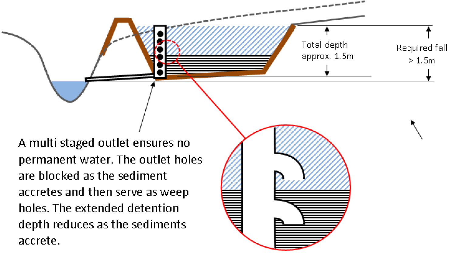
Specific design adaptations for tropical QueenslandAquatic weeds and introduced pasture grasses can be a significant issue in water bodies in tropical Queensland. Although aquatic weeds will have minimal impact on the sediment trapping capacity of the sediment basin they can get flushed out and block or damage downstream infrastructure or treatment systems. Design adaptations to minimise the risk of aquatic weeds is to have dry sediment basins or vegetated sediment basins. Dry Sediment BasinsUnlike typical sediment basins, dry basins do not have a permanent pool. The basin fills up with water during a rain or irrigation event and then drains away. The height that water fills to is called the ‘extended detention’ level. The depth and area of extended detention is critical when designing dry sediment basins to ensure that there is sufficient detention time to allow sediments to drop out of the water column before the system drains (Figure 3). The available extended detention depth and hence sediment storage capacity is reduced as sediment accumulates. To ensure the basin is free draining, a 1.5m deep sediment basin requires at least that same vertical difference between the invert (bottom) of the upstream drain and the water level in the downstream receiving waterbody. Where a dry basin has no gravity outfall, the basin may need to be emptied by pump after events. Another way to keep a sediment basin dry, is to reuse the water on-farm.
Vegetated Sediment BasinsVegetated sediment basins ensure that the inundated areas are already occupied by desirable vegetation (typically reeds and sedges) to limit the growth of weeds. The design of a vegetated sediment basin should incorporate:
Although vegetated basins look like a treatment wetland, they are smaller and deeper and water tends to flow through them faster. Therefore, they don’t have the detention time required for effective removal of nutrients and pesticides. DisclaimerIn addition to the standard disclaimer located at the bottom of the page, please note the content presented is based on published knowledge of treatment systems. Many of the treatment systems described have not been trialled in different regions or land uses in Queensland. The information will be updated as new trials are conducted and monitored. If you have any additional information on treatment systems or suggestions for additional technologies please contact us using the feedback link at the bottom of this page. References
Last updated: 5 November 2022 This page should be cited as: Department of Environment, Science and Innovation, Queensland (2022) Sediment basins — Planning and design, WetlandInfo website, accessed 8 May 2025. Available at: https://wetlandinfo.des.qld.gov.au/wetlands/management/treatment-systems/for-agriculture/treatment-sys-nav-page/sediment-basins/planning-design.html |
Site footer

 — Department of the Environment, Tourism, Science and Innovation