

|
|
WetlandUpdate July 2020Catchment Stories: Upper Brisbane, Water Park, and Great Sandy Strait and Surrounding Catchments.To effectively manage a catchment it is important to have a collective understanding of how the catchment works. Catchment stories use map journals, integrated spatial information, photographs, animations and an informative narrative to demonstrate the features of catchments. These stories describe the location, extent and values of the Upper Brisbane, Water Park, and Great Sandy Strait and Surrounding Catchments (including Great Sandy Strait, K'gari (Fraser Island), Mainland Coastal Catchments, Mary and Susan Catchments). The stories demonstrate the key features which influence water flow, including geology, topography, rainfall and run-off, natural features, human modifications and land uses. The stories also contain key information on the values of the catchment. The information was compiled using the walking the landscape process, where experts systematically work through a catchment in a facilitated workshop, incorporating diverse knowledge of the landscape, to develop catchment stories. Upper Brisbane Catchment
Water Park Catchment
Great Sandy Strait and Surrounding Catchments
Great Sandy Strait (Great Sandy Strait and Surrounding Catchments)
K'gari - Fraser Island (Great Sandy Strait and Surrounding Catchments)
Mainland Coastal Catchments (Great Sandy Strait and Surrounding Catchments)
Susan (Great Sandy Strait and Surrounding Catchments)
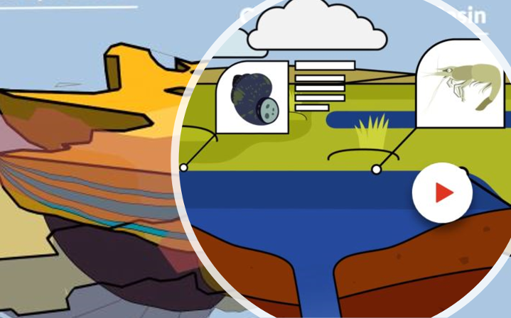
Intertidal and Subtidal ProductsThe Queensland Intertidal and Subtidal Ecosystem Classification scheme (the scheme) provided the understanding and classification of the biological, physical and chemical factors determining the nature and extent of ecosystems that underpins the mapping and ecosystem type descriptions. Three additional attributes support the scheme below. WetlandMaps Reporting ToolThe new reporting tool on WetlandMaps allows users to generate reports based on drawn or selected features. These reports are then emailed to users in PDF format so that they're easy to store and access. The Hydrology of the Great Artesian Basin - animation
This animation describes the basic hydrology of the Great Artesian Basin (GAB), its location, formation and how it functions. The animation was developed through the Queensland Wetlands Program in the Department of Environment and Science, in collaboration with the Department of Natural Resources, Mines and Energy and other key experts. Duration 2m 56s
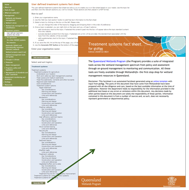
User defined treatment system fact sheet
The user defined treatment systems fact sheet tool allows you to create your own fact sheet based on your needs for treatment systems. Use the topic list and then click the relevant sections you wish to include. Those sections are then placed in a PDF format.
Project Factsheets
The Aquatic Ecosystems/Wetlands Rehabilitation and Research (AEWRR) project will use a values-based approach to develop a plan for investing in the rehabilitation, research and offsetting of impacts to aquatic ecosystems in Queensland.
The Litter and Illegal Dumping Management Framework will provide information to:
Updates
WetlandMaps and WetlandSummaryNew layers on WetlandMaps: Biogeographic subregions; Drainage divisions; and Great Sandy Marine Park shorebird roost sites. Updated layers on WetlandMaps and WetlandSummary: Sewage treatment plants; Sewage treatment plant monitoring points; and Catchment Stories.
Legislation toolboxThe programs, policies and legislation pages have been updated to reflect changes to Queensland’s planning programs, policy and legislation relating to wetlands, aquatic ecosystems and species.
Wetland projects search toolAdditional projects have been added to the wetland projects search tool from Greening Australia and Natural Disaster Relief and Recovery Arrangements. Additional links
WetlandUpdateThe WetlandUpdate is a regular bulletin sent to subscribers to provide them with the latest WetlandInfo resources and tools, as well as case studies, video information and new project fact sheets. WetlandInfo feedback and improvementsContact us via email for feedback, information or questions about wetlands. WetlandInfo feature species - Golden Trevally
Golden Trevally, (Gnathanodon speciosus) juveniles. Photo by Collette Bagnato.
Our July feature species is the Golden Trevally. Adults are silvery grey, with black spots or blotches scattered on their sides, and often faint bands. Juveniles and sub-adults are bright yellow with narrow blackish bars on their head and sides, the first through the eye. Adults can be found in both deep lagoons and seaward reefs. They typically feed by rooting for crustaceans and burrowing invertebrates in the sand but may also feed on small fish. Small juveniles often shelter amongst jellyfish tentacles or protect themselves from predators by "piloting" sharks, other large fish, turtles and in this case a sea snake at Howie Reef.
Additional information
This section is updated regularly, so stay tuned for more! Last updated: 23 July 2020 This page should be cited as: Department of Environment, Science and Innovation, Queensland (2020) WetlandUpdate July 2020, WetlandInfo website, accessed 8 May 2025. Available at: https://wetlandinfo.des.qld.gov.au/wetlands/resources/publications/latest-news/2020-06-25.html |
Site footer

 — Department of the Environment, Tourism, Science and Innovation