

|
|
WetlandUpdate December 2019Queensland Wetland Mapping version 5.0
Updated wetland mapping data (version 5.0 updated to 2017) is now available. It is accessible through:
Due to the mapping update and some classification modifications the following pages have also been updated:
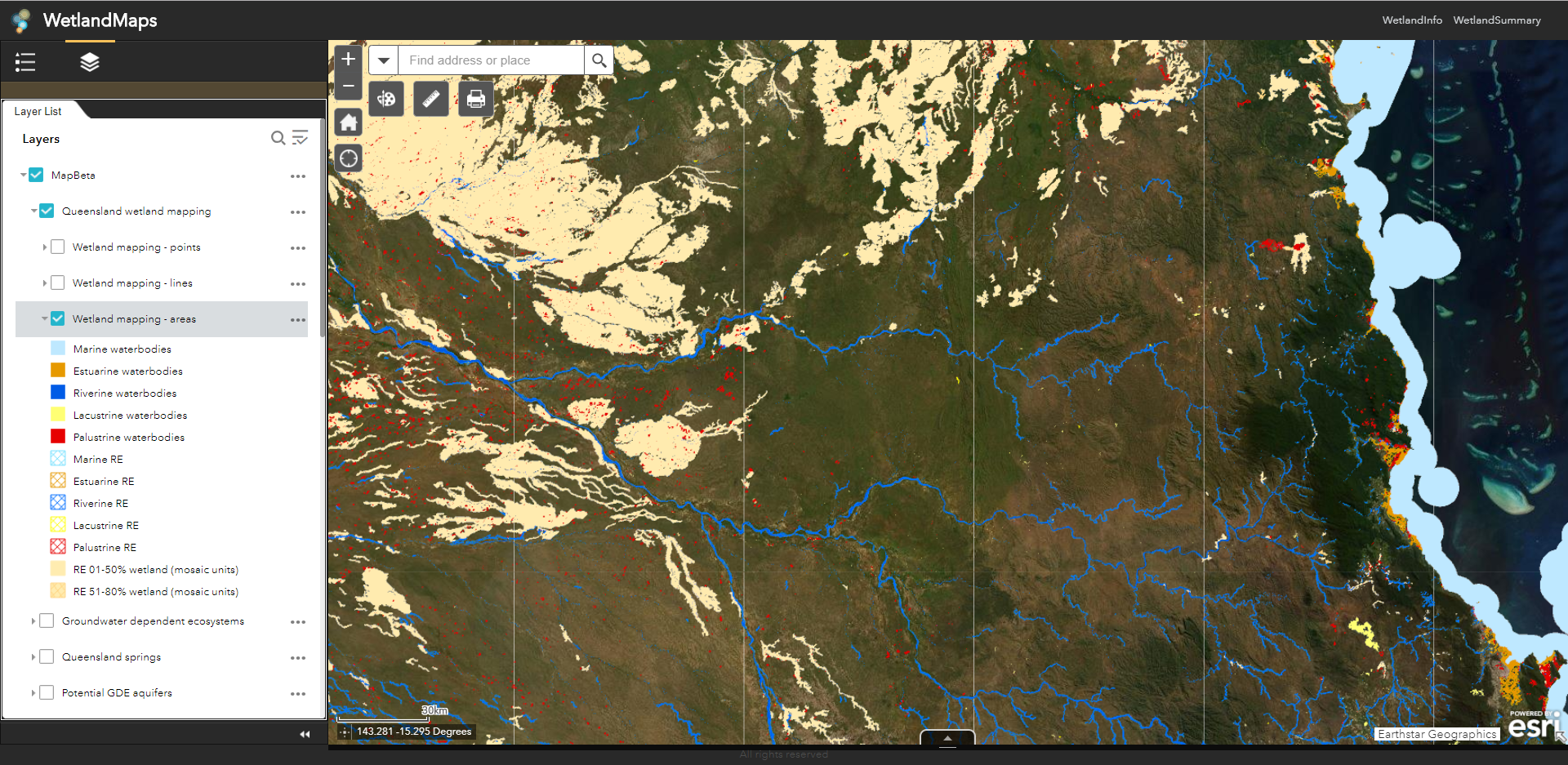
WetlandMaps moved out of BetaWetlandMaps has been updated to make mapping access quicker and more reliable. Please fill in our user feedback survey to help us to continue to improve the map server in future.
Catchment Story: Burnett CatchmentTo effectively manage a catchment it is important to have a collective understanding of how the catchment works. Catchment stories use map journals, integrated spatial information, photographs, animations and an informative narrative to demonstrate the features of catchments. This story describes the location, extent and values of the Burnett Catchment and demonstrates the key features which influence water flow, including geology, topography, rainfall and run-off, natural features, human modifications and land uses. This catchment story was developed in conjunction with the Queensland Reconstruction Authority's Burnett Catchment Flood Resilience Strategy.
Mangrove dieback in the Gulf of Carpentaria: baseline for monitoring future trajectory in QueenslandThe Mangrove dieback in the Gulf of Carpentaria: baseline for monitoring future trajectory in Queensland report, supported by a map journal and swipe maps, provides statistical information on mangrove dieback by catchment across the Queensland portion of the Gulf of Carpentaria. This work establishes a baseline to monitor the trajectory of recovery or decline of the mangrove and associated communities within this area. Mangrove and Associated Communities of Moreton Bay viewer updatedThe Mangroves and associated communities of Moreton Bay swipe-map viewer has been updated with 2016 data. UpdatesPrograms, policies and legislation pageThe programs, policies and legislation pages have been updated to reflect changes to Queensland’s planning programs, policy and legislation relating to wetlands, aquatic ecosystems and species. Intertidal and Subtidal Mapping Scheme's "Applying an Attribute Based Classification Scheme - Poster"This poster, which assists with understanding the seascape-scale intertidal and subtidal ecosystems of the Central Queensland (CQ) coast, is available on the Intertidal and subtidal mapping background page. Wetland projects search toolAdditional projects have been added to the wetland projects search tool. Additional linksUnderstanding coastal erosion on beachesUnderstanding coastal erosion on beaches is a guide for managers, policy makers and citizen scientists and is available on the Wetland management tools and guides page. iNaturalist AustraliaiNaturalist Australia, the Australian node of iNaturalist is the world’s leading global social biodiversity network. The network is now available on the Fauna and Flora pages and can be used to record your individual plant, animal and fungi sightings.. Great Barrier Reef Outlook Report 2019The Great Barrier Reef Outlook Report 2019, a five-yearly report, provides an overview of the condition of the Reef's ecosystem and heritage values, use, influencing factors, management effectiveness, resilience, and risks to its future. The report is available through WetlandSummary on the Great Barrier Reef area page. Shellfish Reef Restoration NetworkGuideline information for the conservation and restoration of shellfish reefs can be found on the Shellfish Reef Restoration Network website. The link is available on WetlandInfo through the Shellfish reefs treatment system page. United Nations (SEEA) free trainingThe System of Environmental-Economic Accounting 2012—Central Framework is a multi-purpose conceptual framework for measuring the interactions between the environment and the economy. It can be accessed on the Training, funding and employment page. Ecological impacts of invasive carp in Australian dryland rivers paperIn Australia, carp are widespread and abundant in the waterways, impoundments, wetlands, and lakes of the Murray–Darling Basin and in some other river systems. This paper outlines the ecological impacts of carp across a number of dryland rivers. Location and geology of the Surat Cumulative Management Area (CMA)The Location and geology of the Surat Cumulative Management Area (CMA) and associated videos are available via the videos page. Introduction to the Surat CMA provides an introductory overview of the Surat CMA. Geology of the Surat CMA shows the basins and geological formations, the complexity of the geological layers, effects of these layers, and movement of groundwater. Towards a Common International Classification of Ecosystem Services (CICES) for Integrated Environmental and Economic AccountingCICES Towards a common classification of ecosystem services resources link is available through the additional information section on the Assessing wetland values and services page. Natural Capital RoadmapThe Natural Capital Roadmap presents the ideas of over 300 leaders in farming, forestry, natural resource management, conservation, finance, policy, research and government on how to progress the natural capital agenda in Australia. The link is also available through the additional information section on the Assessing wetland values and services page. WetlandUpdateThe WetlandUpdate is a regular bulletin sent to subscribers to provide them with the latest WetlandInfo resources and tools, as well as case studies, video information and new project fact sheets. WetlandInfo feedback and improvementsContact us via email for feedback, information or questions about wetlands. WetlandInfo feature animal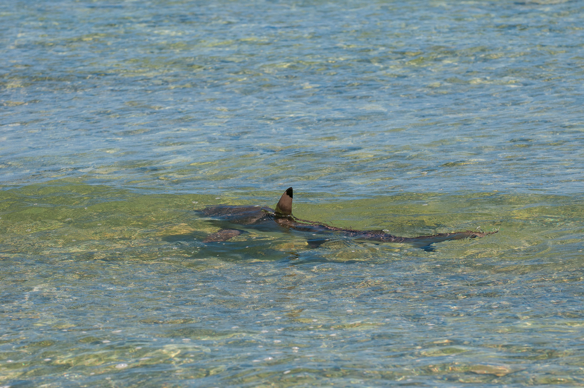
Blacktip reef shark (Carcharhinus melanopterus). Photo by Queensland Museum.
Our October feature animal is the Blacktip reef shark (Carcharhinus melanopterus). It is found in shallow marine waters, usually in association with coral reefs, throughout the tropical Indo-West and Central Pacific. In Australia it is recorded from the central coast of Western Australia around the tropical north and south to southern Queensland. Additional informationWetlandInfo updates this section regularly, so stay tuned for more! Last updated: 14 November 2019 This page should be cited as: Department of Environment, Science and Innovation, Queensland (2019) WetlandUpdate December 2019, WetlandInfo website, accessed 8 May 2025. Available at: https://wetlandinfo.des.qld.gov.au/wetlands/resources/publications/latest-news/2019-10-24.html |
Site footer

 — Department of the Environment, Tourism, Science and Innovation