|
|
WetlandUpdate April 2013Welcome to the new WetlandInfo website!The redeveloped WetlandInfo website is now available. After many months of consultation with stakeholders the new site is more user-friendly, has a new look and feel, improved structure and a suite of upgraded tools and technical capabilities. The most popular tool on WetlandInfo—WetlandSummary—is now accessible with just one click from the homepage and features groundwater dependent ecosystem mapping, many new search areas, a moveable map, direct links to WetlandMaps and much more. If you have bookmarked pages they should be redirected automatically. If, for some reason, you cannot locate the information you are looking for, click on the feedback button in the page footer below. We’re interested in your feedback on the new site, so please take a few moments to fill in our online survey. Groundwater dependent ecosystem mappingIn partnership with other programs, WetlandInfo has been upgraded to include mapping of groundwater dependent ecosystems (GDEs) in key locations across Queensland. GDEs are ecosystems which require access to groundwater, on a permanent or intermittent basis, to meet all or some of their water requirements. Examples of GDEs are aquifers, springs, caves, lakes, palustrine wetlands, rivers and terrestrial ecosystems. A GDE mapping and classification method methodology was developed and applied to generate mapping for the Wide Bay and eastern Murray-Darling Basin. The mapping is supported by a suite of pictorial conceptual models of different GDE types, a set of mapping rule sets and Frequently Asked Questions. The wetland and GDE mapping and classification are available as KMLs (for use with Google Earth or similar program), via the Queensland Government Information Service, and through WetlandMaps. Connectivity frameworkWhen managing a wetland it is important for the surrounding landscape to be considered as this can have a major effect on the wetland. Connectivity looks at the connections between and within aquatic ecosystems, taking a whole-of-catchment approach. The Queensland Wetlands Program developed a framework for evaluating aquatic ecosystem connectivity through expert workshops involving policy makers and scientists from a wide range of disciplines from state, local and federal government bodies and universities. The framework provides a way of understanding and applying connectivity at any level of spatial scale for any management outcome. It can also benefit research in providing a systematic method for the consideration of complex forms of ecological connectivity. Wetland buffer case study (Lake Broadwater)The wetland buffer case study for Lake Broadwater provides an example of how the Queensland Wetland Buffer Planning Guideline can be applied. Lake Broadwater is located approximately 25km south-west of Dalby on the Darling Downs and lies within one of the most intensively cultivated agricultural districts in Queensland. Farming case studiesIn conjunction with the recently published Guidelines and template for preparing a wetland management plan the Queensland Wetlands Program is now releasing 2 accompanying farming and grazing case studies developed in collaboration with local farmers, South West NRM and Wetlands International—Oceania. One case study Establishing a rotational grazing system in box-mulga country, Wallam Creek focuses on establishing a rotational grazing system in box-mulga country thereby optimising ground cover and grazing business outcomes, reducing soil erosion and improving condition of the riparian zone. The other case study Managing water and grazing in Warrego and mulga country provides an example of successfully managing water and grazing in Warrego floodplain and mulga country thereby improving sustainable production, biodiversity and the condition of riverine and other wetland systems. Project fact sheetsThe following fact sheets are now available on WetlandInfo providing an update on the status of current projects or programs:
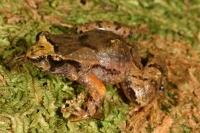
Updates, improvements and linksWetlandUpdateWhen existing resources are updated or new tools are added to WetlandInfo, the WetlandUpdate newsletter is sent to subscribers with the changes featured on a What’s New summary page which has now been renamed to WetlandUpdate. View all of the previous updates WetlandInfo feedback and improvementsSend us useful wetland information and links to add to WetlandInfo. Do you have a wetland question you just can't answer? Email us Our WetlandInfo feature frog is a Taudactylus liemi commonly known as the Eungella Tinkerfrog; Liem's Frog WetlandInfo updates this section regularly, so keep your eyes and ears open! For more information on frogs and to hear their calls, visit the Frogs Australia Network Or view species profiles in your area using the SummaryInfo search tool. Last updated: 22 March 2013 This page should be cited as: Department of Environment, Science and Innovation, Queensland (2013) WetlandUpdate April 2013, WetlandInfo website, accessed 8 May 2025. Available at: https://wetlandinfo.des.qld.gov.au/wetlands/resources/publications/latest-news/2013-04-22.html |

 — Department of the Environment, Tourism, Science and Innovation


