|
|
What's new in February 2013?Pictorial conceptual modellingPictorial conceptual models—also referred to as conceptual diagrams or models—synthesise and communicate how the plants, animals, water, soils and other parts and processes of the wetlands work and to present this information in a visual and simplified way. The models are powerful tools as they offer a way of visualising complex environmental processes that can easily be used and understood by a variety of audiences with varying levels of knowledge. Pictures worth a thousand words: A guide to pictorial conceptual modelling provides scientists, government agencies, extension officers and natural resource management groups and organisations with a step-by-step approach to developing and applying pictorial conceptual models and shows how they can be used to achieve better management outcomes. Wetland management plan guidelines and templateThe Guidelines and template for preparing a wetland management plan explains the concepts and rationale for wetland management planning and outlines a step-by-step process for preparing a wetland management plan. A template allows landholders and other wetland managers to easily insert information for their particular wetland area. These guidelines have been produced for use by landholders engaged in grazing and dryland cropping in two inland river basins of Queensland, the Queensland Murray-Darling and the Bulloo, but most of the material is also applicable much more widely across other regions of Queensland and Australia generally. The guidelines could be used:
‘Walking the landscape’‘Walking the landscape’ offers a holistic approach to understanding and managing the environment. It is a framework that integrates existing data with expert and local knowledge through hands-on workshops to create a common understanding among multidisciplinary teams. It incorporates the available knowledge on landscape flora, fauna, water, soils and ecosystem processes and uses the information to develop conceptual models which link to a map. These models then help answer questions like how the landscape contributes to flood behaviour or why groundwater dependent ecosystems occur in certain locations. The primary aim of the method is to improve evidence-based decision making for the sustainable management and restoration of ecological systems. The method and its fundamental concepts and principles are available in the document Walking the landscape: A whole-of-system framework for understanding and mapping environmental processes and values. Updates, improvements and linksWetlandMapsTwo new layers have recently been added to WetlandMaps:
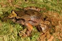
New and improved WetlandInfoThis will be the last release of tools and resources on the current version of WetlandInfo. We have been working hard in the background to redevelop and improve the website and have incorporated many of the great suggestions we have received from our users to make the website more user—friendly. So watch this space - your new and improved WetlandInfo is coming soon! WetlandInfo feedback and improvementsSend us useful wetland information and links to add to WetlandInfo. Do you have a wetland question you just can't answer? Email us Our WetlandInfo feature frog is a Taudactylus liemi WetlandInfo updates this section regularly, so keep your eyes and ears open! For more information on frogs and to hear their calls, visit the Frogs Australia Network Or view species profiles using the SummaryInfo search tool. Last updated: 22 March 2013 This page should be cited as: Department of Environment, Science and Innovation, Queensland (2013) What's new in February 2013?, WetlandInfo website, accessed 8 May 2025. Available at: https://wetlandinfo.des.qld.gov.au/wetlands/resources/publications/latest-news/2013-02-02.html |

 — Department of the Environment, Tourism, Science and Innovation


