

|
|
Groundwater dependent ecosystem mapping backgroundA basic requirement for managing groundwater dependent ecosystems (GDEs) is to know where they exist, and the extent and nature of their dependence on groundwater. Related pages
Quick facts
Groundwater Dependent Ecosystems
In partnership with other programs, the wetland mapping has been enhanced by the mapping of Groundwater Dependent Ecosystems (GDEs). GDEs are ecosystems which require access to groundwater on a permanent or intermittent basis to meet all or some of their water requirements and include aquifers, springs, caves, lakes, palustrine wetlands, rivers and terrestrial ecosystems. A GDE mapping and classification methodology has been developed and is being applied to generate mapping for Queensland. The mapping is supported by a suite of pictorial conceptual models of different GDE types, a set of mapping rule sets and Frequently Asked Questions and handbooks. Groundwater dependent ecosystems (GDEs) mappingQueensland’s GDE mapping builds on existing information, including wetland mapping, regional ecosystem mapping, a spring and small waterholes database, and drainage lines. This information is combined with feedback from a broad range of experts[1]. Only some parts of Queensland have been mapped (see map). The Queensland GDE mapping consists of 5 data sets which need to be combined to show all GDEs. Get mapping helpGet mapping help provides more detailed step-by-step guides for accessing and using the mapping. GDE mapping version historyVersion 1.5—Released April 2017. Includes Queensland groundwater dependent ecosystem mapping from version 1.4 (surface GDE points, lines, and terrestrial and surface GDE areas) with revised mapping for the eastern Murray-Darling Basin. Includes Queensland groundwater dependent ecosystem (subterranean GDE areas) mapping from version 1.4. Version 1.4—Released December 2015. Includes Queensland groundwater dependent ecosystem mapping from version 1.3 (surface GDE lines and terrestrial and surface GDE areas) with additional mapping for the Comet, Dawson and Mackenzie River drainage sub-basins. Queensland groundwater dependent ecosystem (subterranean GDE areas) mapping from version 1.0 with additional mapping for the whole of Queensland. Version 1.3—Released July 2015. Includes Queensland groundwater dependent ecosystem mapping from version 1.2 (surface GDE points, lines, and terrestrial and surface GDE areas) with additional mapping for Lake Eyre Basin and surrounding drainage sub-basins. Version 1.2—Released May 2015. Includes Queensland groundwater dependent ecosystem mapping from version 1.1 (GDE lines, terrestrial GDEs and surface expression GDE areas) with additional mapping for South East Queensland. Version 1.1—Released May 2013. Includes Queensland groundwater dependent ecosystem mapping from version 1.0 (GDE points, lines, terrestrial and surface water area) with additional mapping for the Pumicestone Passage Catchment and Mackay–Whitsunday areas. Version 1.0—Released October 2012. Queensland groundwater dependent ecosystem mapping for the eastern Murray–Darling Basin and Wide Bay–Burnett, based on 2009 extent (GDE points, lines, terrestrial and surface water area). Version 1.0—Released October 2012. Queensland groundwater dependent ecosystem mapping for all of Queensland (subterranean area—caves). Data sets—metadata
Wetland on-line education modulesA series of on-line education modules have been prepared as a resource for people who want to learn more about wetlands. You can use these to meet your learning and training needs. This information should be used in conjunction with information found on this website. 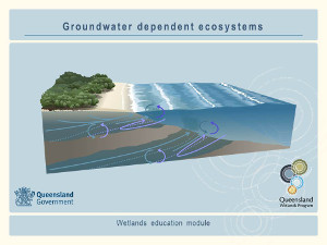 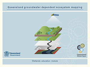 Pages under this sectionReferences
Last updated: 30 August 2016 This page should be cited as: Queensland Government, Queensland (2016) Groundwater dependent ecosystem mapping background, WetlandInfo website, accessed 8 May 2025. Available at: https://wetlandinfo.des.qld.gov.au/wetlands/facts-maps/gde-background/ |

Site footer

 — Department of the Environment, Tourism, Science and Innovation