

|
|
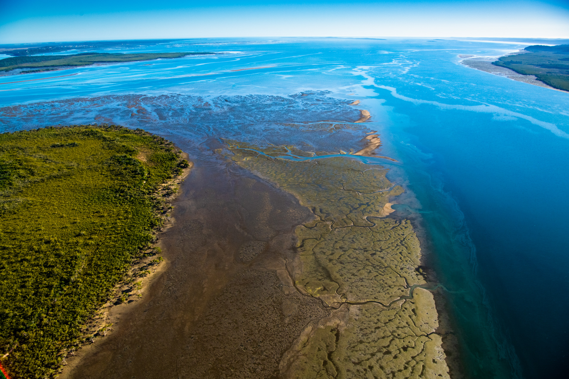
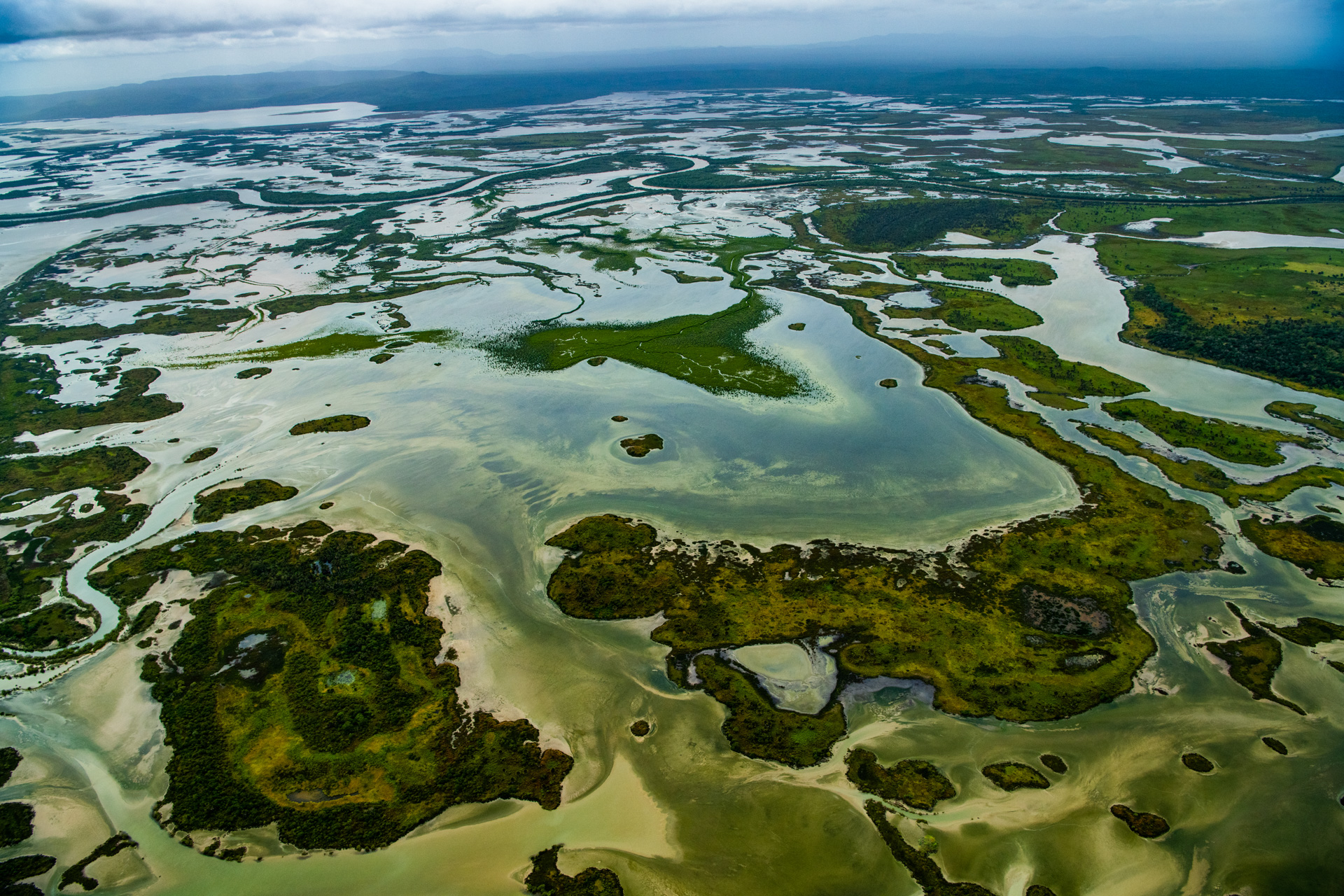
TidesTides are the periodic rise and fall of the ocean surface caused mainly by the gravitational interactions between the Earth, Moon and Sun[1]. Tides disperse as very long waves that originate in the ocean and travel towards coastlines, rivers and estuaries, causing high and low tides. Tides are a process that drives where tidal inundation happens along the shore (i.e. the tidal planes). Tidal range, the height between low tide and high tide, varies spatially and over time.
Quick facts
Tides are a key hydrological process that influences intertidal and subtidal ecosystems. Tides influence how hydrodynamic energy (the energy of water) disperses across the intertidal and shallow subtidal area, with consequences for hydrology, hydrodynamics, mixing, sediment movements, water chemistry and coastal geomorphology. Tidal inundation is a key determinant of ecosystem type and is important for biogeochemical cycles, productivity, trophic cycles in biota as well as processes such as denitrification. Tides both inundate and define the extent of the intertidal area and are essential to maintain connections across tidal areas[6].
Together with waves and riverine runoff, tides (including tidal range) influence estuary function. The timing and volume of freshwater flows and runoff influence the degree of tide-dominance and tidal processes in an estuary. For example, when denser tidal saline water sinks and is replaced by fresher surface water, density-driven currents drive circulation patterns of stratified estuaries. Tidal propagation patterns and the strength of the tidal current differ depending on whether an estuary is tide or wave-dominated. Tide-dominated estuaries have evolved from river infilling and have net sediment export to the ocean, with wide, deep entrances, strong tidal energy and tidal flushing similar to the open ocean. Wave-dominated estuaries, especially those with tidal sandbanks, have attenuated tidal flows close to the estuary entrance and smaller tides upstream. If the sand barrier has closed the entrance, there is no tidal flow at all[5]. Wetland plants and animals respond to tidal gradients in soil wetting / waterlogging, nutrient availability and salinity. Tides determine the zonation of plants and animals in the intertidal area, level of adaptation to emersion in air/immersion in water, and the extent and degree of saline influence. Tides determine migratory shorebirds feeding and roosting habitat productivity, extent and suitability. Tides influence the accessibility of feeding, nursery and reproductive habitat for fish and invertebrates, enabling them to connect with saltmarsh, mangroves, tidal flats and upper tidal pools[2][3]. Tides disperse planktonic larvae and distribute plankton productivity. Climate change influences on estuaries will differ, depending on whether they are tide, wave, or current dominated. For example, tide-dominated estuaries more vulnerable to changes in processes such as sea-level rise and catchment inflows than are wave-dominated estuaries such as ICOLL's. How are tides formed?The sun and moon’s gravitational forces pulls on the earth and it's oceans, counteracted by earth's gravity. The gravitational force from the moon and the sun cause the ocean levels to bulge where the earth is closest to the moon, creating high tides. The impact of the moons gravity is strongest closest to the moon, however, centrifugal force (due to the spinning of the earth) causing high tides[8] on the opposite side of the earth from the moons location. During a full moon or new moon, the sun’s and moon’s gravity align and combine to form a ‘bulge’ of water, causing spring tides. At half moons the respective sun and moon ‘bulges’ are opposite each other and partially cancel each other out, causing neap tides. The term 'king tide' refers to any high tide well above average height[1]. Tides, like other water movements, are restricted by obstructions and frictional drag due to topographic complexity (see ‘sticky water’.) Such effects happen at multiple scales due to continents and landmasses, terrain morphology and roughness of the sea floor, the shape of the coastline and its indentations (bays, estuaries and channels). Where waterways are constrained around coastal islands, reefs, bays and inlets, there may be a tidal delay in comparison to smoother coastlines as channels and complex coastlines constrain the water. The length, width and depth of an estuary influences how a tide propogates in the water body. Constrained by the channels and losing energy due to friction, tides diminish as they travel upstream in tidal rivers and wetlands causing a delay in the tide time. Tidal upstream effects may be strong enough to raise inundation levels in freshwaters and may form a ‘salt wedge’ below the flowing freshwater[12]. In an estuary a salt wedge may influence circulation patterns, mixing and currents. In estuaries, the export and import of sediment can be unequal depending on how the tidal flows have been modified by shallow bathymetry and shape of the estuary. These properties can cause differences between flood and ebb tide current strengths that influence erosion and deposition patterns. There is a feedback effect where erosion and depositional properties change the morphology, which modifies relative flood and ebb tide current strengths. Tidal flats and wetland vegetation such as mangroves and saltmarsh also create friction, slowing the flow of tidal currents, and may diminish tidal ranges[10], reducing coastal hazards due to meteorological events such as storm surge. Importance of tides for wetlandsCoastal, urban, industrial, transport and agricultural development has modified the tidal extent of many wetlands, altering vital wetland processes, cycles and components, notably biota movement or passage, that depend on tidal flows. Rehabilitating tidal hydrological regimes to reconnect wetlands is a focus and priority for several projects targeted at restoring ecosystem processes, notably fish habitat rehabilitation, migratory shorebird habitat[11] and Blue Carbon rehabilitation. Fish and other aquatic fauna require passage between different habitats, and this can include moving between marine and freshwater wetlands and waterways. This is for many reasons, including travel to and from spawning grounds, moving in response to changing water quality, access to food and to evade predators. Returning tidal flows to estuaries previously bunded or reclaimed has the potential to return natural tidal inundation patterns/hydroperiods required by mangroves, saltmarsh and saline coastal swamps, which in many cases return once tidal flows are restored. Mangroves and various saltmarsh communities are associated with specific tidal planes that correspond to these hydroperiods (see Tidal Inundation)[4]. However, tidal planes and vegetation patterns of saltmarsh plants towards the upper tidal planes may be constricted under sea level rise where there is coastal development or farmland, and when accretion of sediment cannot keep up with the rate of sea level rise[9]. Consideration of anticipated sea level rise is important when rehabilitating tidal flows. Sea level rise is anticipated to modify the extent and magnitude of tidal flows in estuaries with restricted entrances[7], increasing the current speed through the entrance, tidal wave propagation inside the estuary and modifying the tidal prism (i.e. tidal planes and corresponding hydroperiods). Useful linksPhysical characteristics of tide-dominated estuaries References
Last updated: 10 June 2024 This page should be cited as: Department of Environment, Science and Innovation, Queensland (2024) Tides, WetlandInfo website, accessed 8 May 2025. Available at: https://wetlandinfo.des.qld.gov.au/wetlands/ecology/processes-systems/tides/ |
Site footer

 — Department of the Environment, Tourism, Science and Innovation