|
|
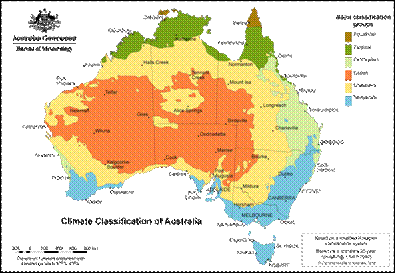
Lacustrine and Palustrine Attribute DefinitionsWetland ClimateClimate is the synthesis of weather observations over a long period. It can be classified into zones using criteria such as rainfall, temperature, humidity and vegetation. The Climate Classification of Australia from the Bureau of Meteorology website is recommended as the base map for this layer (Figure 1). Figure 1: The Climate Classification of Australia map[1] Click here for more information on climate classification Wetland Ecological SystemsThese are the categories identified by Cowardin (1979) and being adopted by Ramsar and DIWA (Environmental Australia 2001). For a brief description of these systems see the system definitions Wetland Geomorphology / TopographyThis layer is derived from topographical maps and vegetation mapping layers to identify different landforms. Three relatively simple landforms are proposed based on floodplain, non-floodplain (springs, soaks and karst), and non-floodplain (depressional). Wetland SubstrateThe substrate layer is the material lying below the soil layer that shows no pedological development. It may or may not be the parent rock of the wetland soil. This layer is proposed as a secondary layer that may be useful in describing wetlands but is not essential for the description. The proposed attributes are those described in McDonald et al., (1990). They summarise more than 70 categories of the more recognisable rock types (for example, igneous, dolerite, limestone). Wetland Water RegimeWater regime stands alone as a component of wetlands that impacts upon all other facets of wetland existence. The presence of water, and its quality, quantity, and source, determines the salient features of a wetland. The information for this subcategory is derived from remote imagery (possibly satellite) of wetland extent over a range of wet and dry periods. Wetland Water TypeWetland water chemistry is, in part, determined by the surrounding landscape and, in turn, dictates features of the wetland such as vegetation. This information can be used to determine the ‘normal’ water chemistry of a waterbody. Vegetation mapping layers are one source of remote sensing information that may be used to derive this subcategory, as well as other documented ground-based information. References
Last updated: 22 March 2013 This page should be cited as: Department of the Environment, Tourism, Science and Innovation, Queensland (2013) Lacustrine and Palustrine Attribute Definitions, WetlandInfo website, accessed 15 December 2025. Available at: https://wetlandinfo.detsi.qld.gov.au/wetlands/what-are-wetlands/definitions-classification/classification-systems-background/methods/classification-category-definitions.html |

 — Department of the Environment, Tourism, Science and Innovation


