

Species profile—Leucopogon cuspidatus
Classification
Plantae (plants) → Equisetopsida (land plants) → Ericaceae → Leucopogon cuspidatus
Sighting data
Species details
- Kingdom
- Plantae (plants)
- Class
- Equisetopsida (land plants)
- Family
- Ericaceae
- Scientific name
- Leucopogon cuspidatus R.Br.
- WildNet taxon ID
- 11563
- Superseded by
- Styphelia cuspidata (09/03/2021)
- Conservation significant
- No
- Confidential
- No
- Endemicity
- Exotic
- Pest status
- Nil
- Short Notes
- BRI 380684
- Description
- Leucopogon cuspidatus is a small shrub growing to 1.2 m tall with a spreading habit and bright green young growth. The leaves are 0.6 to 1 cm long and 0.2 to 0.4 cm wide, dark green and shiny above, paler below, tapering to a sharp, rigid point. Fruits are about 0.5 cm long, egg-shaped, fleshy around a hard stone (Elliot and Jones, 1993). The fruits are fleshy and are translucent orange (Queensland Herbarium, 2012).
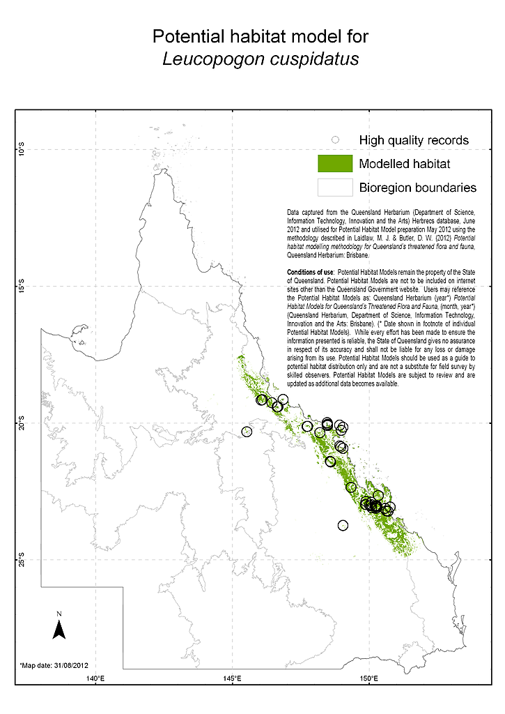
- Map
- View Map
- Distribution
- Leucopogon cuspidatus occurs in eastern Queensland from Blackdown Tableland in the south to the Mount Stewart area near Homestead township in the north. Most collections occur in coastal districts and islands, but collections have been made as far west as Blackdown Tableland. Localities include Mackay, Bowen, Townsville, Gloucester Island, Magnetic Island and in the Marlborough to Yaamba area. The species is reserved in Mount Jim Crow National Park, Magnetic Island National Park, Homevale National Park, Whitsunday Islands National Park, Gloucester Island National Park, Blackdown Tableland National park, Hinchinbrook Island National Park, Mount Zero-Taravale Nature Reserve, Mount Jim Crow National Park, Paluma Range National Park, Whitsunday Islands National Park, Glencoe State Forest and Lake Learmouth State Forest (Queensland Herbarium, 2012).
- Distributional limits
- -21.6083333, 149.8083333
-21.6083334, 149.8083334 - Range derivation
- Range derived from extent of the taxon's verified records
- Habitat
- Most populations of Leucopogon cuspidatus occur in coastal districts and islands. The species usually occurs on hillslopes and has been recorded growing in open forest, woodland and heath on rocky slopes with granitic or serpentinite substrates. Associated species/ vegetation include: woodland on pale coarse sand with Eucalyptus drepanophylla, Corymbia leichhardtii and E. lamprophylla; granite outcrop with Melaleuca and Hoya australis; sandy soil, with E. acmenoides and Lophostemon confertus; Acacia julifera, Eucalyptus exserta, Acacia aulacocarpa, Corymbia trachyphloia, Grevillea low woodland with a sparse mid stratum and a sparse ground stratum; woodland of E. fibrosa, Corymbia xanthope on serpentinite hill; and Lophostemon confertus / Leptospermum neglectum tall shrubland (Queensland Herbarium, 2012).
- Reproduction
- Flowering of Leucopogon cuspidatus has been recorded in March, May-June, August-September and fruiting in March and May (Queensland Herbarium, 2012).
- Threatening processes
- The main potential threats to Leucopogon cuspidatus include inappropriate fire regimes; invasion by weeds; and habitat destruction from mining and cattle grazing. Serpentinite deposits in the Marlborough area are mined and land in this area of central Queensland has been extensively cleared for cattle grazing, cropping, and pastures (Batianoff et al., 2000; DERM, 2009). Mount Abbot, near Bowen, where L. cuspidatus occurs, is subject to frequent and severe fires. Invasion by weeds such as Pink Periwinkle (Catharanthus roseus) may pose a threat in the Cape Gloucester and Gloucester Island areas (Batianoff et al., 1997).
- Status notes
- Leucopogon cuspidatus is Least Concern under the Queensland Nature Conservation Act 1992.
- Management documents
- Department of Sustainability, Environment, Water, Population and Communities (DSEWPC) (2012). Leucopogon cuspidatus in Species Profile and Threats Database, Department of Sustainability, Environment, Water, Population and Communities, Canberra. Available from: http://www.environment.gov.au/sprat. Accessed Wed, 15 Feb 2012 14:04:35 +1100.
- Management recommendations
- Regional and local priority actions for the recovery and protection of Leucopogon cuspidatus and its habitat have been identified by DSEWPC (2012). Actions are identified within six categories which include avoiding habitat loss, disturbance and modification (e.g. monitor known populations and identify key threats); controlling invasive weeds (e.g. develop and implement a management plan for the control of Pink Periwinkle in the region); minimising trampling, browsing or grazing (e.g. manage known sites to ensure appropriate stock grazing regimes); managing fire (develop and implement suitable fire management strategy); increasing conservation awareness (e.g. raise awareness in the local community); and enabling recovery of additional sites and/or populations (e.g. undertake appropriate seed collection and storage).
- Notes
- Occurs in the following Queensland pastoral districts: Cook, Leichhardt, North Kennedy, Port Curtis. The species was previously listed as vulnerable under the EPBC Act 1999.
- References
- Batianoff, G.N., Dillewaard, H.A. and Franks, A.J. (1997). Mackay/Whitsunday Coast Vegetation and Floristics, Part 1: Description, Inventory, and Conservation, Queensland Herbarium, Department of Environment, Indooroopilly.
Batianoff, G.N., Neldner, V.J. and Singh, S. (2000). Vascular Plant Census and Floristic Analysis of Serpentine Landscapes in Central Queensland. Proceedings of the Royal Society of Queensland 109: 1-30.
Department of Sustainability, Environment, Water, Population and Communities (DSEWPC) (2012). Leucopogon cuspidatus in Species Profile and Threats Database, Department of Sustainability, Environment, Water, Population and Communities, Canberra. Accessed 15/02/2012. http://www.environment.gov.au/sprat.
Elliot, W.R. and Jones, D.L. (1993). Encyclopaedia of Australian Plants Suitable for Cultivation, vol. 6. Thomas C Lothian Pty Ltd, Port Melbourne.
Queensland Department of Environment and Resource Management (DERM) (2009). Fire Strategy: Hinchinbrook Island National Park - Edition 2. Queensland Parks and Wildlife Service (QPWS).
Queensland Herbarium (2012). Specimen label information. Queensland Herbarium. Accessed 15/02/2012. - Profile author
- Lynise Wearne (15/02/2012)
Other resources
Data source
This profile data is sourced from the QLD Wildlife Data API using the Get species by ID function used under CC-By 4.0.
https://apps.des.qld.gov.au/species/?op=getspeciesbyid&taxonid=11563.
This information is sourced from the WildNet database managed by the Queensland Department of Environment and Science.
